City of Methuen Master Plan
City of Methuen Master Plan
City of Methuen Master Plan

Create successful ePaper yourself
Turn your PDF publications into a flip-book with our unique Google optimized e-Paper software.
<strong>Methuen</strong> <strong>Master</strong> <strong>Plan</strong> 2007<br />
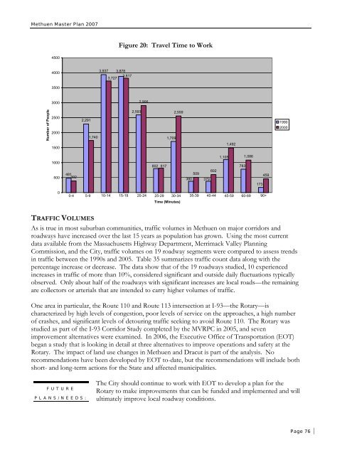
Figure 20: Travel Time to Work<br />
4500<br />
4000<br />
3,937 3,878<br />
3,817<br />
3,727<br />
3500<br />
3000<br />
2,906<br />
Number <strong>of</strong> People<br />
2500<br />
2000<br />
1500<br />
2,291<br />
1,740<br />
2,593<br />
1,709<br />
2,559<br />
1,492<br />
1990<br />
2000<br />
1000<br />
500<br />
481<br />
392<br />
802<br />
817<br />
602<br />
509<br />
380 379<br />
1,105<br />
783<br />
1,086<br />
173<br />
459<br />
0<br />
0-4 5-9 10-14 15-19 20-24 25-29 30-34 35-39 40-44 45-59 60-89 90+<br />
Time (Minutes)<br />
TRAFFIC VOLUMES<br />
As is true in most suburban communities, traffic volumes in <strong>Methuen</strong> on major corridors and<br />
roadways have increased over the last 15 years as population has grown. Using the most current<br />
data available from the Massachusetts Highway Department, Merrimack Valley <strong>Plan</strong>ning<br />
Commission, and the <strong>City</strong>, traffic volumes on 19 roadway segments were compared to assess trends<br />
in traffic between the 1990s and 2005. Table 35 summarizes traffic count data along with the<br />
percentage increase or decrease. The data show that <strong>of</strong> the 19 roadways studied, 10 experienced<br />
increases in traffic <strong>of</strong> more than 10%, considered significant and outside daily fluctuations typically<br />
observed. Only about half <strong>of</strong> the roadways with significant increases are local roads—the remaining<br />
are collectors or arterials that are intended to carry higher volumes <strong>of</strong> traffic.<br />
One area in particular, the Route 110 and Route 113 intersection at I-93—the Rotary—is<br />
characterized by high levels <strong>of</strong> congestion, poor levels <strong>of</strong> service on the approaches, a high number<br />
<strong>of</strong> crashes, and significant levels <strong>of</strong> detouring traffic seeking to avoid Route 110. The Rotary was<br />
studied as part <strong>of</strong> the I-93 Corridor Study completed by the MVRPC in 2005, and seven<br />
improvement alternatives were examined. In 2006, the Executive Office <strong>of</strong> Transportation (EOT)<br />
began a study that is looking in detail at three alternatives to improve operations and safety at the<br />
Rotary. The impact <strong>of</strong> land use changes in <strong>Methuen</strong> and Dracut is part <strong>of</strong> the analysis. No<br />
recommendations have been developed by EOT to-date, but the recommendations will include both<br />
short- and long-term actions for the State and affected municipalities.<br />
FUTURE<br />
PLANS/NEEDS:<br />
The <strong>City</strong> should continue to work with EOT to develop a plan for the<br />
Rotary to make improvements that can be funded and implemented and will<br />
ultimately improve local roadway conditions.<br />
Page 76