City of Methuen Master Plan
City of Methuen Master Plan
City of Methuen Master Plan

Create successful ePaper yourself
Turn your PDF publications into a flip-book with our unique Google optimized e-Paper software.
<strong>Methuen</strong> <strong>Master</strong> <strong>Plan</strong> 2007<br />
***<br />
**<br />
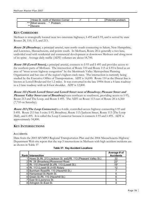
Howe St. north <strong>of</strong> Marston Corner Potential problem.<br />
Most severe. * Problem<br />
Severe<br />
KEY CORRIDORS<br />
<strong>Methuen</strong> is strategically located near two interstate highways, I-495 and I-93, and is served by state<br />
Routes 28, 110, 113, and 213.<br />
Route 28 (Broadway), a principal arterial, runs north–south connecting to Salem, New Hampshire,<br />
and Lawrence, Massachusetts, and points south. In <strong>Methuen</strong>, Route 28 is generally a two-lane,<br />
undivided road with residential and commercial development at downtown <strong>Methuen</strong> and along most<br />
<strong>of</strong> its spine. Average daily traffic (ADT) volumes are about 18,700.<br />
Route 110 (Lowell Street), a principal arterial, connects to I-93 and I-495 and provides access to<br />
the southern parts <strong>of</strong> <strong>Methuen</strong>. The intersection <strong>of</strong> Route 110 and Route 113 at I-93 is listed as an<br />
area <strong>of</strong> “most severe highway congestion” by the Merrimack Valley Metropolitan <strong>Plan</strong>ning<br />
Organization and has one <strong>of</strong> the region’s highest crash rates. The intersection is currently being<br />
studied by the Executive Office <strong>of</strong> Transportation. ADT is 14,690. Route 110 at the Dracut line is<br />
known as Lowell Boulevard for 1.2 miles. It was converted in the late 1990s from a 4-lane roadway<br />
to a 2-lane roadway with an 8-foot shoulder. ADT is 12,800.<br />
Route 113 (North Lowell Street and Lowell Street west <strong>of</strong> Broadway; Pleasant Street and<br />
Pleasant Valley Street east <strong>of</strong> Broadway) runs northeast to southwest, providing access to I-93,<br />
Route 213 and The Loop, and Route I-495. The ADT on Route 113 east <strong>of</strong> Route 28 is 6,560<br />
(7,710 on Saturday).<br />
Route 213 (The Loop Connector) is a 4-mile, controlled-access highway connecting I-93 and<br />
I-495. Route 213 has 5 exits: I-93, Broadway, Route 113/Jackson Street, Route 113 (The Loop<br />
Mall), and I-495. It is called the Loop Connector because it connects I-93 and I-495. ADT is<br />
approximately 54,800.<br />
KEY INTERSECTIONS<br />
Accidents<br />
Data from the 2003 MVMPO Regional Transportation <strong>Plan</strong> and the 2004 Massachusetts Highway<br />
Department Web site report that the top 5 intersections in <strong>Methuen</strong> with high accident incidents are<br />
as shown in Table 37<br />
Table 37: Key Accident Locations<br />
Average # <strong>of</strong><br />
Rank Intersection<br />
Accidents<br />
1 Howe St./Rt. 213 (Jackson St. exit)/Rt. 113 (Pleasant Valley St.) 22<br />
2 Rt. 28 (Broadway)/Rosewood Road 22*<br />
3 Rt. 110 (Haverhill St.)/Rt. 113 (Lowell St.) 19*<br />
4 Rt. 113 (Lowell St.)/I-93 Rotary 12<br />
5 Burnham Road/Rt. 110 (Haverhill St.) 7<br />
6 Hampstead St./North St. 6<br />
6 Green St./Rt. 110 (Haverhill St.) 6<br />
7 East St./Lawrence St. 5<br />
8 Arlington St./East St. 4<br />
Page 78