

Lake Erie North Shore Watershed Plan - Niagara Peninsula ...
Lake Erie North Shore Watershed Plan - Niagara Peninsula ...
Lake Erie North Shore Watershed Plan - Niagara Peninsula ...

You also want an ePaper? Increase the reach of your titles
YUMPU automatically turns print PDFs into web optimized ePapers that Google loves.
LAKE ERIE NORTH SHORE WATERSHED PLAN<br />
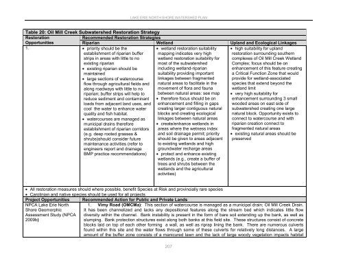
Table 20: Oil Mill Creek Subwatershed Restoration Strategy<br />
Restoration<br />
Recommended Restoration Strategies<br />
Opportunities<br />
Riparian Wetland Upland and Ecological Linkages<br />
1. priority should be the<br />
establishment of riparian buffer<br />
strips in areas with little to no<br />
existing riparian<br />
existing riparian should be<br />
maintained<br />
large sections of watercourse<br />
flow through agricultural fields and<br />
along roadways with little to no<br />
riparian; buffer strips will help to<br />
reduce sediment and contaminant<br />
loads from adjacent land uses, and<br />
cool the water to enhance water<br />
quality and fish habitat.<br />
watercourses are managed as<br />
municipal drains therefore<br />
establishment of riparian corridors<br />
(e.g. deep rooted grasses &<br />
shrubs)should consider future<br />
maintenance activities (refer to<br />
engineers report and drainage<br />
BMP practice recommendations)<br />
wetland restoration suitability<br />
mapping indicates very high<br />
wetland restoration suitability for<br />
most of the subwatershed<br />
including wetland-riparian<br />
suitability providing important<br />
linkages between fragmented<br />
natural areas to facilitate in the<br />
movement of flora and fauna<br />
between natural areas: see map<br />
therefore focus should be on<br />
enhancement and filling in gaps<br />
creating larger contiguous natural<br />
blocks and creating ecological<br />
linkages between natural areas<br />
create/enhance wetlands in<br />
areas where the wetness index<br />
and soil drainage permit; priority<br />
should be given to areas adjacent<br />
to existing wetlands and high<br />
groundwater recharge areas<br />
protect and enhance existing<br />
wetlands (e.g., create a buffer of<br />
trees and shrubs between the<br />
wetlands and the agricultural<br />
activities)<br />
high suitability for upland<br />
restoration surrounding southern<br />
complexes of Oil Mill Creek Wetland<br />
Complex; focus should be on<br />
enhancement of this feature creating<br />
a Critical Function Zone that would<br />
provide for wetland-associated<br />
species that extend beyond the<br />
wetland limit<br />
very high suitability for<br />
enhancement surrounding 3 small<br />
wooded areas on east side of<br />
subwatershed creating one large<br />
natural block. Opportunity exists to<br />
connect to watercourse and with<br />
riparian creation connect to<br />
fragmented natural areas<br />
existing natural areas should be<br />
preserved<br />
All restoration measures should where possible, benefit Species at Risk and provincially rare species<br />
Carolinian and native species should be used for all projects<br />
Project Opportunities Recommended Action for Public and Private Lands<br />
NPCA <strong>Lake</strong> <strong>Erie</strong> <strong>North</strong> 1. Vimy Road (OMCMa): This section of watercourse is managed as a municipal drain; Oil Mill Creek Drain.<br />
<strong>Shore</strong> Geomorphic<br />
Assessment Study (NPCA<br />
2009b)<br />
It has been channelized and lacks any depositional features along the stream bed which indicates little flow<br />
diversity within the channel. Bank instability is present in the form of bare soil extending up the bank, as well as<br />
slumping. Bank protection structures exist along both banks at this field site. These structures consist of concrete<br />
blocks laid on top of each other forming a wall, as well as riprap lining the bank. There are numerous culverts<br />
found within this site and the water flows through some of these culverts for relatively long distances. A large<br />
amount of the buffer zone consists of a manicured lawn and the lack of large woody vegetation impacts habitat<br />
207


