

Lake Erie North Shore Watershed Plan - Niagara Peninsula ...
Lake Erie North Shore Watershed Plan - Niagara Peninsula ...
Lake Erie North Shore Watershed Plan - Niagara Peninsula ...

Create successful ePaper yourself
Turn your PDF publications into a flip-book with our unique Google optimized e-Paper software.
DRAFT<br />
LAKE ERIE NORTH SHORE WATERSHED PLAN<br />
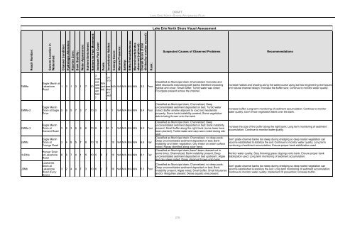
<strong>Lake</strong> <strong>Erie</strong> <strong>North</strong> <strong>Shore</strong> Visual Assessment<br />
Reach Number:<br />
General Location in<br />
<strong>Watershed</strong>:<br />
Channel Condition:<br />
Hydrologic Alteration:<br />
Riparian Zone:<br />
Bank Stability:<br />
Water Appearance:<br />
Nutrient Enrichment:<br />
Barriers to Fish Movement:<br />
Instream Fish Cover:<br />
Pools:<br />
Invertebrate Habitat:<br />
Canopy Cover:<br />
Manure Presence:<br />
Salinity:<br />
Riffle Embeddedness:<br />
Marcroinvertebrates<br />
observed (optional):<br />
Overall Score (Total<br />
divided by number scored):<br />
Rank:<br />
Suspected Causes of Observed Problems<br />
Recommendations<br />
EMMa<br />
Eagle Marsh at<br />
<strong>Lake</strong>shore<br />
Road<br />
1 3 1 3 1 7 10<br />
2<br />
(can<br />
not<br />
see<br />
stre<br />
am<br />
bed<br />
)<br />
N/A<br />
(out<br />
let)<br />
1<br />
(ca<br />
nno<br />
t<br />
see N/A N/A N/A N/A N/A 3.2 Poor<br />
stre<br />
am<br />
bed<br />
)<br />
Classified as Municipal drain; Channelized; Concrete and<br />
steel structures exist along both banks therefore impacting<br />
habitat and cover; Small buffer; Turbid water was noted;<br />
Floodgate present across the channel.<br />
Increase habitat and shading along the watercourse using soil bio-engineering techniques<br />
and natural channel design; Increase the buffer size; Continue to monitor water quality.<br />
EMMa-2<br />
Eagle Marsh<br />
Drain at Eagle<br />
Drive<br />
5 6 5 7 3 7 10 5 1 9 1 N/A N/A N/A N/A 5.4 Poor<br />
Classified as Municipal drain; Channelized; Deep<br />
unconsolidated sediment deposited on bed; Turbid water<br />
noted; Buffer smaller adjacent to road and residential<br />
property; Some bank instability present; Some vegetative<br />
debris being thrown onto the bank.<br />
Increase buffer; Long term monitoring of sediment accumulation; Continue to monitor<br />
water quality; Don't throw vegetated debris over the bank.<br />
EMMa-3<br />
EMMc<br />
HvDMa<br />
LBMb<br />
Eagle Marsh<br />
Drain at<br />
Cement Road<br />
Eagle Marsh<br />
Drain at<br />
Youngs Road<br />
Hoover Drain<br />
at <strong>Lake</strong>shore<br />
Road<br />
Lowbanks<br />
Drain at<br />
<strong>Lake</strong>shore<br />
Road (Furry<br />
Drain)<br />
3 6 3 5 6 6 10 8 8 10 1 N/A N/A N/A N/A 5.9 Poor<br />
3 4 8 5 7 8 10 10 1 7 10 N/A N/A N/A N/A 6.6 Fair<br />
6 6 7 4 1 5 10 5 6 7 10 N/A N/A N/A N/A 6.1 Fair<br />
3 2 4 4 7 3 10 6 2 7 10 N/A N/A N/A N/A 5.3 Poor<br />
Classified as Municipal drain; Channelized; Deep<br />
unconsolidated sediment deposited on bed; Bank instability<br />
present; Small buffer along the right bank (some trees have<br />
been planted); Turbid water and carp were noted during site<br />
visit.<br />
Classified as Municipal drain; Channelized, no deep pools;<br />
Deep unconsolidated sediment deposited on bed; Bank<br />
instability and fallen vegetation; Oily sheen on water surface<br />
noted; Riprap identifed along outer bend.<br />
Classified as Municipal drain (hasn't been cleaned out in<br />
some time); Channelized; Bank instability present; Deep<br />
unconsolidated sediment deposited on bed upstream; Algae<br />
and oily sheen noted; Grass clippings thrown onto bank.<br />
Classified as Municipal drain; Channelized, no deep pools;<br />
Deep unconsolidated sediment deposited on bed; Bank<br />
instability present; Algae noted; Small buffer; Small tributaries<br />
and/or rills/gullies present; Dense aquatic vine present.<br />
Increase the size of the buffer along the right bank; Long term monitoring of sediment<br />
accumulation; Continue to monitor water quality.<br />
Don't grade channel banks too steep during dredging so deep rooted vegetation can<br />
become established & stabilize the soil; Continue to monitor water quality; Long term<br />
monitoring of sediment accumulation; Ensure proper bank stabilization used.<br />
Monitor water quality; Stop throwing grass clippings onto bank; Ensure proper bank<br />
stabilization used; Long term monitoring of sediment accumulation.<br />
Don't grade channel banks too steep during dredging so deep rooted vegetation can<br />
become established & stabilize the soil; Long term monitoring of sediment accumulation;<br />
Continue to monitor water quality; Implement rill prevention; Increase buffer.<br />
276


