

Lake Erie North Shore Watershed Plan - Niagara Peninsula ...
Lake Erie North Shore Watershed Plan - Niagara Peninsula ...
Lake Erie North Shore Watershed Plan - Niagara Peninsula ...

You also want an ePaper? Increase the reach of your titles
YUMPU automatically turns print PDFs into web optimized ePapers that Google loves.
LAKE ERIE NORTH SHORE WATERSHED PLAN<br />
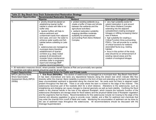
Table 23: Bay Beach Area Drain Subwatershed Restoration Strategy<br />
Restoration Opportunities Recommended Restoration Strategies<br />
Riparian Wetland Upland and Ecological Linkages<br />
1. priority should be placed on<br />
establishing riparian buffer<br />
habitat in areas with little to no<br />
buffer strip<br />
riparian buffers will help to<br />
reduce sediment and<br />
contaminant loads from adjacent<br />
land uses, and cool the water to<br />
enhance water quality and fish<br />
habitat before outletting to <strong>Lake</strong><br />
<strong>Erie</strong><br />
watercourses are managed as<br />
municipal drains therefore<br />
establishment of riparian<br />
corridors (e.g. deep rooted<br />
grasses & shrubs)should<br />
consider future maintenance<br />
protect existing wetlands (e.g.,<br />
create a buffer of trees and shrubs<br />
between the wetlands and the<br />
agricultural activities)<br />
wetland restoration suitability<br />
mapping identifies moderate<br />
suitability for enhancement<br />
surrounding Point Abino Wetland<br />
Complex<br />
very high suitability exists for<br />
upland restoration in and around<br />
Point Abino Wetland Complex<br />
extending into the adjacent<br />
subwatershed creating ecological<br />
linkages or infilling increasing interior<br />
size of feature<br />
high suitability for creating a<br />
Critical Function Zone surrounding<br />
PSW‟s. This will provide for a variety<br />
of critical functions for wetlandassociated<br />
fauna (e.g. nesting<br />
habitat)<br />
focus in this portion of the study<br />
area should be on enhancement of<br />
existing natural areas and the<br />
creation of ecological linkages<br />
activities (refer to engineers<br />
report and drainage BMP<br />
practice recommendations)<br />
All restoration measures should, where possible, benefit Species at Risk and provincially rare species<br />
Carolinian and native species should be used for all projects<br />
Project Opportunities<br />
NPCA <strong>Lake</strong> <strong>Erie</strong> <strong>North</strong><br />
<strong>Shore</strong> Geomorphic<br />
Assessment Study (NPCA<br />
2009b)<br />
Recommended Action for Public and Private Lands<br />
1. 1. <strong>Erie</strong> Road (BBADMa): This section of watercourse is managed as a municipal drain; Bay Beach Area Drain.<br />
It has been channelized and lacks any depositional features along the stream bed which indicate little flow<br />
diversity within the channel. Bank instability is present in the form of bare soil extending up the bank and relatively<br />
deep unconsolidated sediment is deposited along the channel bed. No pools exist but there is stagnant water<br />
present throughout the field site. There is an area where the lawn is mowed to the edge of the channel. This<br />
watercourse becomes part of the roadside ditch for a short distance. Alterations to the watercourse, such as<br />
straightening and dredging can cause changes to channel geometry as well as bank stability. Confining the flood<br />
waters to the channel results in the loss of the adjacent floodplain, which impacts the hydraulic function of the<br />
watercourse (floodplains are storage areas for flood waters) and the physical habitat (loss of floodplain vegetation<br />
and the organisms that live there). Recommendations for this watercourse include not mowing to the edge of the<br />
channel and allowing vegetation to grow to provide cover, habitat, and a filter for sediment and chemicals that<br />
may enter the channel from runoff of fields and roads. Monitoring the accumulation of sediment can be done by<br />
the use of sediment traps throughout the watercourse.<br />
Drainage Superintendent.<br />
All recommendations should be discussed with the<br />
229


