- Page 1 and 2: OPEN-FILE REPORT 06-10 Geologic Map
- Page 3 and 4: TABLE OF CONTENTS Introduction…
- Page 5 and 6: mylonitic, augen textures………
- Page 7 and 8: INTRODUCTION LOCATION AND ACCESS Th
- Page 9 and 10: SAWATCH RANGE RIFT-SHOULDER UPLIFT
- Page 11 and 12: of the South Arkansas River (subseq
- Page 13 and 14: EXPLANATION Rio Grande Rift Neogene
- Page 15 and 16: in descriptions of the geologic uni
- Page 17 and 18: During the Early and Middle Paleozo
- Page 19 and 20: Mountains, and White River uplifts
- Page 21 and 22: field are the largest remnants of t
- Page 23 and 24: Figure 5. Detailed geologic-structu
- Page 25 and 26: with the Colorado mineral belt (Boo
- Page 27 and 28: Shannon, 2005). Widmann and others
- Page 29 and 30: the Upper Arkansas graben (fig. 5)
- Page 31 and 32: 15-minute quadrangle, which is adja
- Page 33 and 34: etween the northern and southern se
- Page 35 and 36: on U.S. Forest Service color aerial
- Page 37 and 38: We use fractional map units on the
- Page 39 and 40: Qpt Pinedale till, undivided (late
- Page 41 and 42: weathered, but Mount Princeton quar
- Page 43 and 44: stratified, matrix-supported, bould
- Page 45 and 46: as rockfalls, rock avalanches, rock
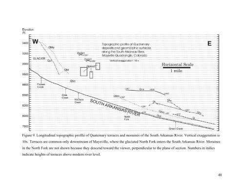
- Page 47: stream-channel deposits of all pere
- Page 51 and 52: Figure 11. View west up South Arkan
- Page 53 and 54: valley near the eastern map boundar
- Page 55 and 56: lithologies are variable and depend
- Page 57 and 58: Arkansas River in parts of Redman C
- Page 59 and 60: angular to subangular. Deposits gen
- Page 61 and 62: elations, age constraints from foss
- Page 63 and 64: elated to the inferred Squaw Creek
- Page 65 and 66: Figure 14. Crude bedding in coarse
- Page 67 and 68: microcline, and muscovite. The latt
- Page 69 and 70: Volcanic Ash Figure 17. View of eas
- Page 71 and 72: Figure 18. Close-up view of intense
- Page 73 and 74: The western zone of brecciated Pale
- Page 75 and 76: Tr Rhyolite dikes (early to late Ol
- Page 77 and 78: as the overall N47°E trend of the
- Page 79 and 80: One age determination on the rhyoli
- Page 81 and 82: northwest-trending fault. Thus, fie
- Page 83 and 84: on the North Fork leucogranite intr
- Page 85 and 86: A small 400 by 400 foot body of Nor
- Page 87 and 88: N12°E, 62°NW (about 6,000 ft sout
- Page 89 and 90: The age of the quartz latite porphy
- Page 91 and 92: Tma Mount Aetna quartz monzonite po
- Page 93 and 94: of the Maysville quadrangle and the
- Page 95 and 96: Mount Aetna ring dikes (Tma), one i
- Page 97 and 98: the margins of the pluton, includin
- Page 99 and 100:
Shannon (1988). The average of seve
- Page 101 and 102:
indicating a granite b composition
- Page 103 and 104:
analysis by Crawford (1913), two an
- Page 105 and 106:
locally tanish to pinkish gray. It
- Page 107 and 108:
quadrangle (tables 1 and 3) were fr
- Page 109 and 110:
slices of Paleozoic sedimentary roc
- Page 111 and 112:
south-southwest of Maysville is a 9
- Page 113 and 114:
There is one additional Paleozoic s
- Page 115 and 116:
near the southwest margin of the qu
- Page 117 and 118:
eastern contact of the diorite intr
- Page 119 and 120:
endoskarn zones. The two widely sep
- Page 121 and 122:
Xhig) along the southeastern contac
- Page 123 and 124:
Xgd Granodiorite (Early Proterozoic
- Page 125 and 126:
Hybrid granodiorite is locally deve
- Page 127 and 128:
Xcs Calc-silicate gneiss (Early Pro
- Page 129 and 130:
Many of the calc-silicate gneiss zo
- Page 131 and 132:
typically expressed by intermittent
- Page 133 and 134:
The field relations and characteris
- Page 135 and 136:
the north side of all three segment
- Page 137 and 138:
eplaced by muscovite. The western m
- Page 139 and 140:
sillimanite-quartz-muscovite that a
- Page 141 and 142:
sillimanite gneiss (Xmsg) and the m
- Page 143 and 144:
Figure 35. Outcrop of Proterozoic h
- Page 145 and 146:
samples) indicates they are compose
- Page 147 and 148:
Xal Lineated amphibolite (Early Pro
- Page 149 and 150:
of the Proterozoic metamorphic rock
- Page 151 and 152:
that the present structural configu
- Page 153 and 154:
elated to rotation of domain blocks
- Page 155 and 156:
sometimes terminate at a cross stru
- Page 157 and 158:
limestone that is exposed in a wind
- Page 159 and 160:
quadrangle are intimately associate
- Page 161 and 162:
of the quadrangle. The north-northw
- Page 163 and 164:
quartz monzonite ring dikes (Tma).
- Page 165 and 166:
that truncates the Upper Arkansas g
- Page 167 and 168:
as at the mouth of Squaw Creek. How
- Page 169 and 170:
adjacent to the southwestern edge o
- Page 171 and 172:
graben and the Upper Arkansas Valle
- Page 173 and 174:
GEOLOGIC HAZARDS Potential geologic
- Page 175 and 176:
In addition, older landslides may h
- Page 177 and 178:
sparse vegetation. One such area is
- Page 179 and 180:
Table 7. Historical (pre-instrument
- Page 181 and 182:
4262272N. ECONOMIC GEOLOGY Currentl
- Page 183 and 184:
A number of the larger pegmatite bo
- Page 185 and 186:
River placers near Buena Vista (Van
- Page 187 and 188:
The small mines and prospects along
- Page 189 and 190:
elatively recent (post-1970) explor
- Page 191 and 192:
contact of two Quaternary gravels (
- Page 193 and 194:
quadrangle. The first area is a clu
- Page 195 and 196:
y Sharp (1976) to be a fault slice
- Page 197 and 198:
quadrant of the Maysville quadrangl
- Page 199 and 200:
the large Paleozoic rock outlier) i
- Page 201 and 202:
WATER RESOURCES Water resources on
- Page 203 and 204:
water near Maysville is being produ
- Page 205 and 206:
to Rudy C. Epis: Colorado School of
- Page 207 and 208:
University, M.Sc. thesis, 50 p. Din
- Page 209 and 210:
Hutchinson, R.M., and Hedge, C.E.,
- Page 211 and 212:
Litsey, L.R., 1958, Stratigraphy an
- Page 213 and 214:
County, Colorado, in Berg, R.R., an
- Page 215 and 216:
Stark, J.T., and Barnes, F.F., 1935
- Page 217 and 218:
Tweto, O., 1987, Rock units of the
- Page 219 and 220:
quadrangle, Colorado: U.S. Geologic
- Page 221 and 222:
94A 391996 4263422 Prospect YXp;Xbf
- Page 223 and 224:
336A 396189 4274961 Prospect Xgdf B
- Page 225:
854 391849 4268852 42 Adit; Geochem