Active Transportation Plan - City of Pomona
Active Transportation Plan - City of Pomona
Active Transportation Plan - City of Pomona

You also want an ePaper? Increase the reach of your titles
YUMPU automatically turns print PDFs into web optimized ePapers that Google loves.
<strong>Pomona</strong> <strong>Active</strong> <strong>Transportation</strong> <strong>Plan</strong><br />
November 2012<br />
Chapter 8 – Bicycle and Pedestrian Design Guidelines<br />
Class III Bicycling Routes<br />
Class III bicycling routes are<br />
intended to provide continuity<br />
throughout a bikeway network<br />
and are primarily identified with<br />
signage. Bicycling routes can be<br />
used to connect discontinuous<br />
segments <strong>of</strong> a Class I or Class II<br />
bikeway. Bicycling routes are<br />
shared facilities either with<br />
motorists on roadways or with<br />
pedestrians on sidewalks (not<br />
desirable).<br />
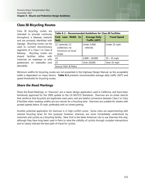
Table 8-2 – Recommended Guidelines for Class III Facilities<br />
Curb Lane Width (in<br />
feet)<br />
12’ (arterial); 11’<br />
(collector); no<br />
minimum on local<br />
street<br />
Average Daily<br />
Traffic (ADT)<br />
Under 5,000<br />
vehicles<br />
Travel Speed<br />
Under 25 mph<br />
14’ 5,000 – 20,000 25 – 35 mph<br />
15’ Over 20,000 Over 35 mph<br />
Source: Fehr & Peers<br />
Minimum widths for bicycling routes are not presented in the Highway Design Manual, as the acceptable<br />
width is dependent on many factors. Table 8-2 presents recommended average daily traffic (ADT) and<br />
speed thresholds for bicycling routes.<br />
Share the Road Markings<br />
Share the Road Markings, or “sharrows” are a newer design application used in California, and have been<br />
tentatively approved for the 2009 update to the CA MUTCD Standards. Sharrows are on-street stencils<br />
that reinforce that bicyclists are legitimate road users, and are helpful connectors between Class I or Class<br />
II facilities when roadway widths are too narrow for a bicycling lane. Sharrows are suitable for streets with<br />
posted speeds below 35 mph, preferably with on-street parking.<br />
Another potential application for sharrows is in high-conflict zones. Some cities are experimenting with<br />
colored bicycling lanes for this purpose; however, sharrows are more immediately understood by<br />
motorists and cyclists as a bicycling facility. New York is the latest American city to use sharrows this way,<br />
although they have long been used in Paris to raise the visibility <strong>of</strong> cyclists through complex intersections<br />
and to clearly indicate the best path <strong>of</strong> travel for cyclists.<br />
152