Active Transportation Plan - City of Pomona
Active Transportation Plan - City of Pomona
Active Transportation Plan - City of Pomona

You also want an ePaper? Increase the reach of your titles
YUMPU automatically turns print PDFs into web optimized ePapers that Google loves.
As part <strong>of</strong> the <strong>Pomona</strong> Bicycle Master <strong>Plan</strong> project, Fehr & Peers developed a list <strong>of</strong> proposed bicycle<br />
facilities for the <strong>City</strong> with the goal <strong>of</strong> increasing connectivity and generally expanding the dedicated<br />
bicycle network. Fehr & Peers assessed the proposed facilities for feasibility and classified the proposed<br />
facilities based on the facility type that could be implemented under current configurations or with<br />
associated modifications. This appendix describes the methodology behind the assessment and presents<br />
the findings in tabular format, where applicable.<br />
We assessed the facilities against criteria specific to the group they were presented in. In some cases,<br />
they were assessed against criteria from other groups to determine if a facility could be built to a higher<br />
level. The criteria are as follows:<br />
Class 1 Bikeways: We measured the typical width and horizontal clearance in Google Earth for sections<br />
where these might be constraining factors. The minimum width for a Class 1 Bikeway is considered to be<br />
10’ for this study, with at least 2’ <strong>of</strong> clearance on each side from other obstructions. Crossings at streets<br />
or physical barriers were also assessed, with special considerations noted.<br />
Class 2 Bike Lanes: Feasibility is determined by comparing the actual curb-to-curb width <strong>of</strong> a roadway<br />
with the minimum width necessary to support the current number <strong>of</strong> lanes plus 5’ bike lanes in each<br />
direction. For this analysis, the minimum lane widths are considered to be 10’ for through/turn lanes, and<br />
12’ for lanes that are curb-adjacent. Where parking is permitted, 8’ was added to the total lane width.<br />
Painted medians and two-way left turn lanes were considered to be through/turn lanes in most cases.<br />
Raised medians and curb lines are considered to be static; these analyses assume that no physical<br />
construction or demolition would occur.<br />
Through this comparison we determined if bike lanes can be installed along a roadway segment without<br />
decreasing the number <strong>of</strong> lanes or eliminating any parking. The analysis typically breaks proposed<br />
improvement sections into smaller segments depending on changes in layout or physical characteristics.<br />
Thus a bike lane may be feasible within one block and infeasible within the next block if lanes are added<br />
or total width changes.<br />
Class 3 Bike Routes: Bike routes are typically selected where connectivity could be improved by filling<br />
gaps in the system, but there isn’t sufficient space to install bike lanes. For this analysis, the total widths<br />
<strong>of</strong> the proposed bike route streets were compared to the minimum widths necessary for bike lanes (as<br />
outlined previously) to ensure that a full Class 2 facility could not be implemented.<br />
Future Potential Bicycle Facilities: Feasibility for different facility types was tested using the steps above.<br />
In many cases, public input, bicycle network gaps, and accessibility to key destinations indicated that there<br />
was demand for a facility that could not be implemented with the existing roadway configuration. These<br />
locations will undergo future study to determine the feasibility <strong>of</strong> bicycle facility implementation and<br />
consideration <strong>of</strong> new treatments that will result in the provision <strong>of</strong> bicycle facilities.<br />
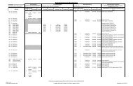
This appendix shows the results <strong>of</strong> the analysis along with notes about facilities and any field<br />
measurements or observations. This was done where the total width was within 4’ <strong>of</strong> the minimum width.<br />
Tables comparing widths show the difference between the necessary width and existing width in the<br />
columns labeled “Delta”, and use a color coding system to indicate feasibility <strong>of</strong> improvements. Green<br />
indicates feasible, red indicated infeasible. A blue color indicates a value within 4’ <strong>of</strong> the minimum, which<br />
was therefore verified in the field.