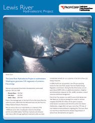
The Lewis River Hydroelectric Projects - PacifiCorp
The Lewis River Hydroelectric Projects - PacifiCorp
The Lewis River Hydroelectric Projects - PacifiCorp

You also want an ePaper? Increase the reach of your titles
YUMPU automatically turns print PDFs into web optimized ePapers that Google loves.
Eagle Cliff Park—Local Welcome Sign<br />
Location:<br />
Size:<br />
Title:<br />
Main<br />
Content:<br />
Eagle Cliff Park<br />
TBD<br />
Eagle Cliff Park<br />
Welcome to Eagle Cliff Park. This facility is owned and operated by the<br />
power company <strong>PacifiCorp</strong>, which provides public recreation<br />
opportunities along the reservoirs of the <strong>Lewis</strong> <strong>River</strong>.<br />
This park and day use area provides access to the <strong>Lewis</strong> <strong>River</strong> above the<br />
uppermost hydroelectric reservoir, Swift Reservoir. You’re in the shadow<br />
of Mt. St. Helens here, with many opportunities for backcountry<br />
recreation.<br />
Sidebar:<br />
One of the oldest known travel routes through this region—the Klickitat<br />
Trail—passed close by Eagle Cliff, following the North Fork of the <strong>Lewis</strong><br />
<strong>River</strong> from Chelatchie Prairie to Yakama country. This ancient trail<br />
provided access to and from the high valleys of the Cascades for local<br />
Indian tribes, and had been a long-established trade route by the time<br />
railway surveyor George B. McClellan passed this way in 1853, noting<br />
flatly that “...the valley of the Cathlapoot’l [<strong>Lewis</strong>]...is utterly worthless<br />
for any purpose.”<br />
McClellan’s dour description notwithstanding, the next century saw<br />
increased use of the <strong>Lewis</strong> <strong>River</strong> route through the Cascades. Indians on<br />
their way to and from trading fairs and horse races in the Indian Heaven<br />
region... prospectors chasing rumors of gold in the mountain streams...<br />
Homesteaders from the lower valley headed upriver to camp, hunt, and<br />
fish... through the decades, travelers of all sorts passed by here on what<br />
was then a dusty, muddy, and rugged trail.<br />
By the 1910s, a wagon road from Woodland had reached the Cougar<br />
region—but beyond that point, only bootprints and hoofprints marked<br />
the way. <strong>The</strong> route (then called the <strong>Lewis</strong> <strong>River</strong> Trail) became the<br />
responsibility of the newly-created US Forest Service. <strong>The</strong> agency<br />
expanded, improved, and maintained the trail as access to remote<br />
operations in the upper <strong>Lewis</strong> <strong>River</strong> and beyond. <strong>The</strong>se operations<br />
included fire prevention, fire detection (the trail was a critical access line<br />
for regional fire lookouts), and recreational structures such as trail<br />
shelters.<br />
Sidebar<br />
Caption:<br />
Forest Service logo, or photo of Forest Service at work; map of FS sites upriver<br />
Today, the Forest Service continues to be a player in the story of the<br />
<strong>Lewis</strong> <strong>River</strong>. Much of the river’s upper watershed lies on National Forest<br />
lands, and many recreationists are drawn to the region by the nearby Mt.<br />
St. Helens National Volcanic Monument, administered by the Forest<br />
Service.<br />
Appendix 1: panel profiles <strong>Lewis</strong> <strong>River</strong> Draft I&E Plan page 50