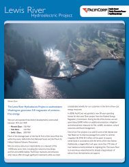
The Lewis River Hydroelectric Projects - PacifiCorp
The Lewis River Hydroelectric Projects - PacifiCorp
The Lewis River Hydroelectric Projects - PacifiCorp

You also want an ePaper? Increase the reach of your titles
YUMPU automatically turns print PDFs into web optimized ePapers that Google loves.
<strong>Lewis</strong> <strong>River</strong> Interpretive & Education Plan<br />
several farms were purchased and their inhabitants moved to other locations.<br />
Some residents held out for several years, until the dam was nearly complete.<br />
Construction of the Ariel Dam (now called Merwin Dam) was begun in 1929.<br />
Trees were felled around the margins of what would become the lake, although<br />
the timber along the river was left standing (this was not the case with Yale and<br />
Swift Dams, where timber was harvested throughout much of the lake’s footprint<br />
before flooding).<br />
Although construction of the first unit of the Ariel Dam was not completed until<br />
1932, the tunnel that diverted water around the dam was closed as early as 1930<br />
and water began to fill the valley at that time.<br />
<strong>The</strong> lake and dam were renamed by H.J. Campbell, publisher of the Vancouver<br />
Columbian, for L. T. Merwin of the Northwestern Electric Company.<br />
Two additional projects, in 1949 and 1958, expanded the dam. Today, the<br />
Merwin Dam is a concrete-arch dam, with a total crest length of 1300 feet and a<br />
maximum height above its lowest foundation of 314 feet. Lake Merwin is about<br />
14.5 miles long, with a surface area of approximately 4000 acres at full pool<br />
level. Its maximum storage capacity is approximately 406,500 acre-feet, which is<br />
equivalent to over 137 billion gallons. Its average annual generation is 517,812<br />
Mwh, enough to power over 68,100 homes (based on an average household<br />
electric use of 7600 kwh for Pacific states).<br />
Merwin Dam and the adjacent powerhouse are on the National Register of<br />
Historic Places. Both the dam and the powerhouse were built with Art Decostyle<br />
architectural elements such as lamp-posts and building corners.<br />
Yale Project<br />
Construction of the Yale Project began in 1951, and continued until 1953. This<br />
project includes two dams: a main embankment and an auxiliary “saddle” dam<br />
that prevents spillover through a neighboring declivity.<br />
Yale Dam and Yale Lake were named for the nearby town of Yale, which,<br />
according to the Tacoma Public Library’s Washington Place Names database,<br />
was given the name Yale over the second choice Spillel (or perhaps Spillei)<br />
because of its brevity.<br />
Unlike the Merwin Dam, the Yale dams are not concrete but constructed of<br />
rock fill, with material taken from the site. <strong>The</strong> Yale Dam is a “rolled earthfill<br />
embankment” type dam with a crest length of 1305 feet and a maximum height<br />
of 323 feet above its lowest foundation. <strong>The</strong> Saddle Dam is approximately 1600<br />
feet long and 40 feet high. Yale Lake is approximately 10.5 miles long, with a<br />
surface area of approximately 3800 acres at full pool level. Its maximum storage<br />
Sea Reach Ltd • 146 NE yamhill Street • Sheridan, OR draft 3 • November 2008 • page 68