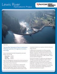
The Lewis River Hydroelectric Projects - PacifiCorp
The Lewis River Hydroelectric Projects - PacifiCorp
The Lewis River Hydroelectric Projects - PacifiCorp

Create successful ePaper yourself
Turn your PDF publications into a flip-book with our unique Google optimized e-Paper software.
<strong>Lewis</strong> <strong>River</strong> Interpretive & Education Plan<br />
Natural History<br />
Geology<br />
[note: <strong>The</strong> <strong>Lewis</strong> <strong>River</strong> is divided into the North Fork and East Fork regions,<br />
with the division occurring at Woodland. <strong>PacifiCorp</strong>’s reservoirs, and all sites<br />
identified in this document, lie on the North Fork of the <strong>Lewis</strong>. In the interest of<br />
simplicity, for the purposes of this document, “<strong>Lewis</strong> <strong>River</strong>” will refer specifically<br />
to the North Fork].<br />
<strong>The</strong> <strong>Lewis</strong> <strong>River</strong> flows from the Cascade Range—a north-south trending range<br />
of mountains that stretches from northern California to southern British<br />
Columbia. <strong>The</strong>se rugged, geologically-rich mountains are part of the “Ring of<br />
Fire”: a great arc of volcanic mountains that rim the Pacific Ocean. Like all Ring<br />
of Fire ranges, the Cascades are the product of the slow collision of the Pacific<br />
tectonic plate against a continental plate—in this case, the North American<br />
plate.<br />
At the juncture between these two plates, the heavier Pacific plate creeps<br />
underneath the North American plate. As this happens, the sinking rocks<br />
of the oceanic plate melt under the intense heat and pressure of Earth’s deep<br />
mantle. <strong>The</strong> molten rock flows upward through complex layers of volcanic,<br />
sedimentary, and metamorphic bedrock that were formed during previous plate<br />
action. Where the molten rock returns to the surface, it has formed tall, conical<br />
volcanoes that rise prominently above their non-volcanic neighbors. Mt. St.<br />
Helens, Mt. Shasta, Mt. Hood, and Mt. Rainier are just a few of these familiar,<br />
picturesque volcanoes.<br />
<strong>The</strong> Cascades began their rise over 50 million years ago. During the Miocene<br />
epoch (13 to 25 million years ago), they reached a peak of volcanism; many<br />
of today’s volcanoes emerged during that period. In subsequent millennia,<br />
eruptions throughout the range deposited complex strata of ash, basalt, clay, and<br />
mud. Meanwhile, the action of water—in the form of glaciers and rivers—carved<br />
deeply into the rising range, creating the region’s steep valleys. <strong>The</strong> <strong>Lewis</strong> <strong>River</strong><br />
flows through—and shapes—such a valley, working its way down through layers<br />
of volcanic rock, mud, and ash, carrying away and depositing this debris in<br />
downstream regions.<br />
Although the Cascades may seem relatively quiet in our human timescale, they<br />
remain a work in progress. Eruptions continue today, with the most recent<br />
major events being the eruption of Mt. Lassen in 1914-1917 and the eruption<br />
of Mt. St. Helens in 1980. <strong>The</strong> latter eruption had a profound impact on the<br />
<strong>Lewis</strong> <strong>River</strong> Basin, as the upper portion of the basin lies on the slopes of Mt. St.<br />
Helens. Although much of the volcano’s explosive power was vented to the north<br />
and west, lahars (mudflows) did extend to the upper waters of the <strong>Lewis</strong>, and<br />
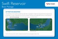
impacts reached to Swift Reservoir, where lahars descended Pine Creek, Muddy<br />
<strong>River</strong> and Swift Creek and deposited a large amount of debris in the reservoir.<br />
Sea Reach Ltd • 146 NE yamhill Street • Sheridan, OR draft 3 • November 2008 • page 56