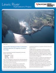
The Lewis River Hydroelectric Projects - PacifiCorp
The Lewis River Hydroelectric Projects - PacifiCorp
The Lewis River Hydroelectric Projects - PacifiCorp

You also want an ePaper? Increase the reach of your titles
YUMPU automatically turns print PDFs into web optimized ePapers that Google loves.
Caption:<br />
Near the <strong>Lewis</strong>’s mouth, average annual precipitation is 37 inches, while<br />
at higher elevations it can reach 140 inches. Most of this falls between<br />
November and March, which translates at high elevation to massive<br />
amounts of snow (exceeding 200 inches in many places). Snowmelt<br />
sustains the river through the dry summers, providing water for fish<br />
habitat, wetlands and wildlife. Winter warm spells and spring thaws<br />
bring rain-on-snow events that can quickly raise river levels.<br />
Caption:<br />
Images:<br />
<strong>The</strong> health of our watersheds is critical to our health. But it’s not always<br />
easy to see (or act) from a watershed perspective. To do so, we need to<br />
look beyond our own artificial boundaries to the natural boundaries of<br />
our watersheds. What watershed do you live in What watersheds to you<br />
work or play in How do your actions affect those watersheds How can<br />
you work to keep those watersheds healthy, or to make them healthier<br />
Map of North Fork <strong>Lewis</strong> watershed. Images from St. Helens eruption.<br />
Scenics of small mountain streams, larger streams. Icons for watershed<br />
stewardship caption.<br />
Appendix 1: panel profiles <strong>Lewis</strong> <strong>River</strong> Draft I&E Plan page 53