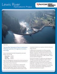
The Lewis River Hydroelectric Projects - PacifiCorp
The Lewis River Hydroelectric Projects - PacifiCorp
The Lewis River Hydroelectric Projects - PacifiCorp

You also want an ePaper? Increase the reach of your titles
YUMPU automatically turns print PDFs into web optimized ePapers that Google loves.
<strong>Lewis</strong> <strong>River</strong> Interpretive & Education Plan<br />
times the <strong>Lewis</strong> <strong>River</strong>’s normal flow.<br />
<strong>The</strong> cause of the flood was discovered within two days. In a high mountain<br />
depression in the headwaters of Dry Creek (which enters the <strong>Lewis</strong> <strong>River</strong><br />
almost within sight of the Beaver Bay boat launch), rain and snowmelt had<br />
accumulated, forming a lake. <strong>The</strong> lake rested in a bowl of basalt formed by a<br />
100-year-old lava flow, which lay atop soft sediments, which in turn lay atop<br />
another basalt flow. Both lava flows were riddled with lava tubes that had been<br />
packed full of sediment. <strong>The</strong> water had worked its way through the lava, forcing<br />
sediment out of some of the tubes and causing faster and faster lake drainage as<br />
the blockages eroded away. Downstream, the increasing torrent ripped deep into<br />
the ground and surged into the <strong>Lewis</strong> <strong>River</strong>.<br />
Before it abated, the flood scoured a 600-foot-deep canyon (Christmas Canyon)<br />
adjoining the <strong>Lewis</strong> <strong>River</strong>. <strong>The</strong> surge carried trees and other debris downstream,<br />
dumping it by the ton into the newly-formed Lake Merwin. Ariel Dam operators<br />
allowed the maximum amount of water to surge through the dam’s structure,<br />
but water still rose, eventually overtopping the spillway. Flooding downstream at<br />
Woodland was extensive with flows exceeding 133,000 cfs. <strong>The</strong> island between<br />
Swift No. 2 powerhouse and Beaver Bay was created by this event.<br />
<strong>The</strong> high lake continued to drain, creating a muddy flood through Christmas<br />
Canyon, for over a month after the initial breach.<br />
Sea Reach Ltd • 146 NE yamhill Street • Sheridan, OR draft 3 • November 2008 • page 87