Appendix 1 Land Allocations Local Plan
Appendix 1 Land Allocations Local Plan
Appendix 1 Land Allocations Local Plan

You also want an ePaper? Increase the reach of your titles
YUMPU automatically turns print PDFs into web optimized ePapers that Google loves.
Dover District Council<br />
<strong>Land</strong> <strong>Allocations</strong> <strong>Local</strong> <strong>Plan</strong> Adopted 2015<br />
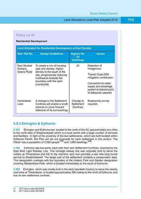
113<br />
Policy LA 35<br />
Residential Development<br />
<strong>Land</strong> Allocated for Residential Development at East Studdal<br />
Site / Ref No.<br />
Design Guidelines<br />
Approx No.<br />
Of<br />
Dwellings<br />
Issues<br />
East Studdal<br />
Nursery,<br />
Downs Road<br />
To create a mix of housing<br />
type and density. Higher<br />
density to the south of the<br />
site, progressively reducing<br />
northwards towards the<br />
boundary with the open<br />
countryside<br />
30<br />
Retention of<br />
Hedgerows<br />
Thanet Coast SPA<br />
mitigation contribution<br />
Connection to water<br />
supply and sewerage<br />
system at nearest point<br />
of adequate capacity<br />
Homestead<br />
Lane<br />
A change to the Settlement<br />
Confines will enable a small<br />
scheme to come forward<br />
reflective of its surroundings<br />
Change to<br />
Settlement<br />
Confines<br />
Biodiversity survey<br />
required.<br />
3.6.3 Elvington & Eythorne<br />
3.363 Elvington and Eythorne are located to the north of the A2, approximately two miles<br />
to the north east of Shepherdswell which is a local centre with a large number of services<br />
and facilities. In light of the proximity of the two settlements, which are both located within<br />
Eythorne Parish, this <strong>Plan</strong> will set out proposals for each settlement in this section. The<br />
Parish has a population of 2,594 people (31) and 1,065 dwellings (32) .<br />
3.364 Eythorne has two parts, each with their own Settlement Confines, bisected by the<br />
East Kent Light Railway Line. This heritage railway line was originally built to serve the<br />
colliery at Tilmanstone and link to the mainline, and now provides a two mile long tourist<br />
service to Shepherdswell. The larger part of the settlement contains a conservation area.<br />
This designation overlaps with the boundary of the Historic Park and Garden designation<br />
covering Waldershare Park, which is located immediately to the south of Eythorne.<br />
3.365 Elvington, which was mostly built in the early twentieth Century to serve the nearby<br />
coal mine at Tilmanstone, is located approximately 300 metres to the north of Eythorne, and<br />
has its own settlement confines.<br />
31 2011 Census table QS103EW<br />
32 2011 Census table QS418EW