Appendix 1 Land Allocations Local Plan
Appendix 1 Land Allocations Local Plan
Appendix 1 Land Allocations Local Plan

Create successful ePaper yourself
Turn your PDF publications into a flip-book with our unique Google optimized e-Paper software.
Dover District Council<br />
<strong>Land</strong> <strong>Allocations</strong> <strong>Local</strong> <strong>Plan</strong> Adopted 2015<br />
121<br />
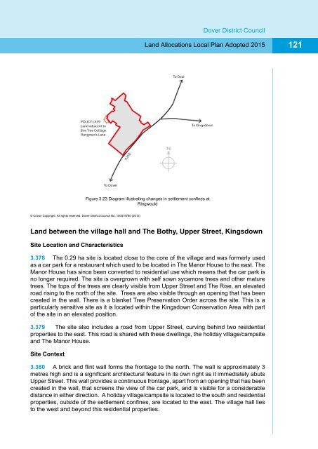
Figure 3.23 Diagram illustrating changes in settlement confines at<br />
Ringwould<br />
© Crown Copyright. All rights reserved. Dover District Council No. 100019780 (2012)<br />
<strong>Land</strong> between the village hall and The Bothy, Upper Street, Kingsdown<br />
Site Location and Characteristics<br />
3.378 The 0.29 ha site is located close to the core of the village and was formerly used<br />
as a car park for a restaurant which used to be located in The Manor House to the east. The<br />
Manor House has since been converted to residential use which means that the car park is<br />
no longer required. The site is overgrown with self sown sycamore trees and other mature<br />
trees. The tops of the trees are clearly visible from Upper Street and The Rise, an elevated<br />
road rising to the north of the site. Trees are also visible through an opening that has been<br />
created in the wall. There is a blanket Tree Preservation Order across the site. This is a<br />
particularly sensitive site as it is located within the Kingsdown Conservation Area with part<br />
of the site in an elevated position.<br />
3.379 The site also includes a road from Upper Street, curving behind two residential<br />
properties to the east. This road is shared with these dwellings, the holiday village/campsite<br />
and The Manor House.<br />
Site Context<br />
3.380 A brick and flint wall forms the frontage to the north. The wall is approximately 3<br />
metres high and is a significant architectural feature in its own right as it immediately abuts<br />
Upper Street. This wall provides a continuous frontage, apart from an opening that has been<br />
created in the wall, that screens the view of the car park, and is visible for a considerable<br />
distance in either direction. A holiday village/campsite is located to the south and residential<br />
properties, outside of the settlement confines, are located to the east. The village hall lies<br />
to the west and beyond this residential properties.