Appendix 1 Land Allocations Local Plan
Appendix 1 Land Allocations Local Plan
Appendix 1 Land Allocations Local Plan

Create successful ePaper yourself
Turn your PDF publications into a flip-book with our unique Google optimized e-Paper software.
Dover District Council<br />
<strong>Land</strong> <strong>Allocations</strong> <strong>Local</strong> <strong>Plan</strong> Adopted 2015<br />
91<br />
3.286 Capel-le-Ferne is located in a prominent cliff-top position, with properties on the<br />
Old Dover Road having extensive views across the English Channel. The AONB is adjacent<br />
to the built form in a number of places at the edge of the village. The undeveloped land<br />
located between the sea and the Old Dover Road is also protected as Heritage Coast. As<br />
a consequence there are very limited development opportunities that would not damage the<br />
setting of the AONB or the character of the village itself.<br />
3.287 Perhaps as a consequence of its countryside and coastal position, the settlement<br />
is a popular tourist destination. The settlement has three static caravan parks each with their<br />
own on-site facilities. In addition, a large number of visitors are attracted to Capel-le-Ferne<br />
to visit the Battle of Britain Memorial.<br />
3.288 The settlement has a village hall, a primary school and two churches. A farmers'<br />
market operates each week from the village hall. Capel-le-Ferne’s location, on the western<br />
fringe of the District, means that the town of Folkestone is used for many services and<br />
facilities. At the time the settlement hierarchy was established the Parish Council welcomed<br />
additional housing accompanied with improved infrastructure, including a doctor’s surgery.<br />
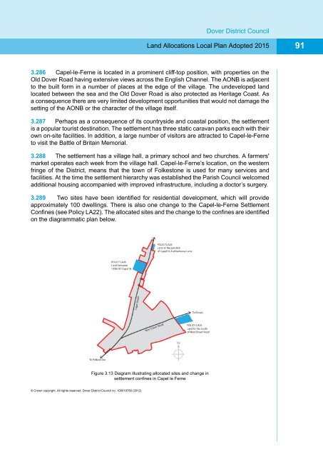
3.289 Two sites have been identified for residential development, which will provide<br />
approximately 100 dwellings. There is also one change to the Capel-le-Ferne Settlement<br />
Confines (see Policy LA22). The allocated sites and the change to the confines are identified<br />
on the diagrammatic plan below.<br />
Figure 3.13 Diagram illustrating allocated sites and change in<br />
settlement confines in Capel le Ferne<br />
© Crown copyright. All rights reserved. Dover District Council no. 100019780 (2012)