Appendix 1 Land Allocations Local Plan
Appendix 1 Land Allocations Local Plan
Appendix 1 Land Allocations Local Plan

Create successful ePaper yourself
Turn your PDF publications into a flip-book with our unique Google optimized e-Paper software.
Dover District Council<br />
<strong>Land</strong> <strong>Allocations</strong> <strong>Local</strong> <strong>Plan</strong> Adopted 2015<br />
83<br />
3.5 <strong>Local</strong> Centres<br />
3.5.1 Ash<br />
3.251 Ash is located in the northern part of the District approximately 2.5km to the west<br />
of Sandwich and a similar distance from Wingham to the east. It is one of the largest villages<br />
in the District, within a parish consisting of a population of 3,365 people (17) and 1,392<br />
dwellings. (18)<br />
3.252 The village has a wide range of commercial and community facilities including a<br />
Doctor's surgery, primary school, two churches, village hall (with library) and a range of<br />
shops including a post office. Ash is located approximately 3.5km from the Discovery Park<br />
Enterprise Zone, which is just north of Sandwich.<br />
3.253 To help sustain and strengthen Ash's role in the Settlement Hierarchy, it is considered<br />
that additional housing will be required over the lifespan of this <strong>Plan</strong>. The constraints on<br />
development relate to the impact on the wider landscape as the village is highly visible from<br />
the south, and heritage, as there are three conservation areas and numerous listed buildings<br />
in the village.<br />
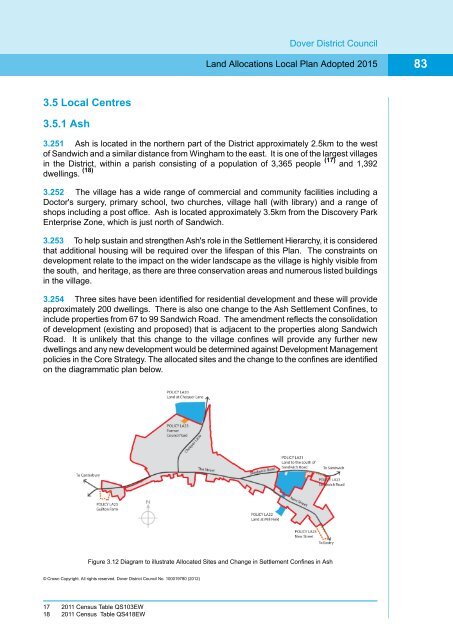
3.254 Three sites have been identified for residential development and these will provide<br />
approximately 200 dwellings. There is also one change to the Ash Settlement Confines, to<br />
include properties from 67 to 99 Sandwich Road. The amendment reflects the consolidation<br />
of development (existing and proposed) that is adjacent to the properties along Sandwich<br />
Road. It is unlikely that this change to the village confines will provide any further new<br />
dwellings and any new development would be determined against Development Management<br />
policies in the Core Strategy. The allocated sites and the change to the confines are identified<br />
on the diagrammatic plan below.<br />
Figure 3.12 Diagram to illustrate Allocated Sites and Change in Settlement Confines in Ash<br />
© Crown Copyright. All rights reserved. Dover District Council No. 100019780 (2012)<br />
17 2011 Census Table QS103EW<br />
18 2011 Census Table QS418EW