Appendix 1 Land Allocations Local Plan
Appendix 1 Land Allocations Local Plan
Appendix 1 Land Allocations Local Plan

You also want an ePaper? Increase the reach of your titles
YUMPU automatically turns print PDFs into web optimized ePapers that Google loves.
Dover District Council<br />
18<br />
<strong>Land</strong> <strong>Allocations</strong> <strong>Local</strong> <strong>Plan</strong> Adopted 2015<br />
3.2 The above requirements need to be adjusted to take account of the strategic allocations<br />
made in the Core Strategy, housing completions since 2006 and the stock of unimplemented<br />
permissions. Table 3.1 sets out the residual amount to be allocated in this <strong>Plan</strong> in each part<br />
of the District after taking account of these factors.<br />
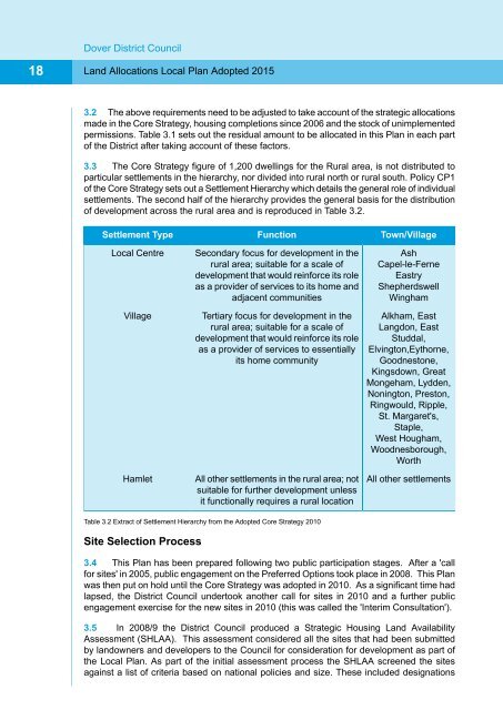
3.3 The Core Strategy figure of 1,200 dwellings for the Rural area, is not distributed to<br />
particular settlements in the hierarchy, nor divided into rural north or rural south. Policy CP1<br />
of the Core Strategy sets out a Settlement Hierarchy which details the general role of individual<br />
settlements. The second half of the hierarchy provides the general basis for the distribution<br />
of development across the rural area and is reproduced in Table 3.2.<br />
Settlement Type<br />
<strong>Local</strong> Centre<br />
Village<br />
Hamlet<br />
Function<br />
Secondary focus for development in the<br />
rural area; suitable for a scale of<br />
development that would reinforce its role<br />
as a provider of services to its home and<br />
adjacent communities<br />
Tertiary focus for development in the<br />
rural area; suitable for a scale of<br />
development that would reinforce its role<br />
as a provider of services to essentially<br />
its home community<br />
All other settlements in the rural area; not<br />
suitable for further development unless<br />
it functionally requires a rural location<br />
Town/Village<br />
Ash<br />
Capel-le-Ferne<br />
Eastry<br />
Shepherdswell<br />
Wingham<br />
Alkham, East<br />
Langdon, East<br />
Studdal,<br />
Elvington,Eythorne,<br />
Goodnestone,<br />
Kingsdown, Great<br />
Mongeham, Lydden,<br />
Nonington, Preston,<br />
Ringwould, Ripple,<br />
St. Margaret's,<br />
Staple,<br />
West Hougham,<br />
Woodnesborough,<br />
Worth<br />
All other settlements<br />
Table 3.2 Extract of Settlement Hierarchy from the Adopted Core Strategy 2010<br />
Site Selection Process<br />
3.4 This <strong>Plan</strong> has been prepared following two public participation stages. After a 'call<br />
for sites' in 2005, public engagement on the Preferred Options took place in 2008. This <strong>Plan</strong><br />
was then put on hold until the Core Strategy was adopted in 2010. As a significant time had<br />
lapsed, the District Council undertook another call for sites in 2010 and a further public<br />
engagement exercise for the new sites in 2010 (this was called the 'Interim Consultation').<br />
3.5 In 2008/9 the District Council produced a Strategic Housing <strong>Land</strong> Availability<br />
Assessment (SHLAA). This assessment considered all the sites that had been submitted<br />
by landowners and developers to the Council for consideration for development as part of<br />
the <strong>Local</strong> <strong>Plan</strong>. As part of the initial assessment process the SHLAA screened the sites<br />
against a list of criteria based on national policies and size. These included designations