Appendix 1 Land Allocations Local Plan
Appendix 1 Land Allocations Local Plan
Appendix 1 Land Allocations Local Plan

You also want an ePaper? Increase the reach of your titles
YUMPU automatically turns print PDFs into web optimized ePapers that Google loves.
Dover District Council<br />
134<br />
<strong>Land</strong> <strong>Allocations</strong> <strong>Local</strong> <strong>Plan</strong> Adopted 2015<br />
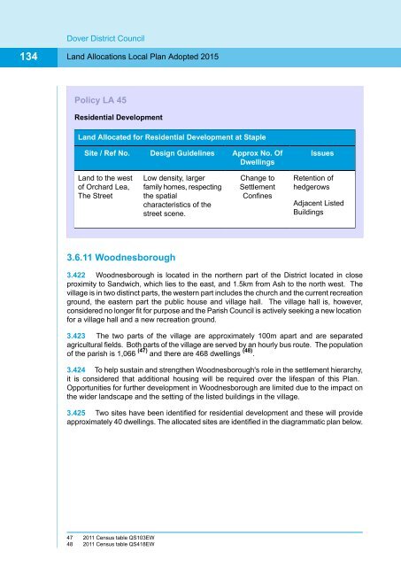
Policy LA 45<br />
Residential Development<br />
<strong>Land</strong> Allocated for Residential Development at Staple<br />
Site / Ref No.<br />
Design Guidelines<br />
Approx No. Of<br />
Dwellings<br />
Issues<br />
<strong>Land</strong> to the west<br />
of Orchard Lea,<br />
The Street<br />
Low density, larger<br />
family homes, respecting<br />
the spatial<br />
characteristics of the<br />
street scene.<br />
Change to<br />
Settlement<br />
Confines<br />
Retention of<br />
hedgerows<br />
Adjacent Listed<br />
Buildings<br />
3.6.11 Woodnesborough<br />
3.422 Woodnesborough is located in the northern part of the District located in close<br />
proximity to Sandwich, which lies to the east, and 1.5km from Ash to the north west. The<br />
village is in two distinct parts, the western part includes the church and the current recreation<br />
ground, the eastern part the public house and village hall. The village hall is, however,<br />
considered no longer fit for purpose and the Parish Council is actively seeking a new location<br />
for a village hall and a new recreation ground.<br />
3.423 The two parts of the village are approximately 100m apart and are separated<br />
agricultural fields. Both parts of the village are served by an hourly bus route. The population<br />
of the parish is 1,066 (47) and there are 468 dwellings (48) .<br />
3.424 To help sustain and strengthen Woodnesborough's role in the settlement hierarchy,<br />
it is considered that additional housing will be required over the lifespan of this <strong>Plan</strong>.<br />
Opportunities for further development in Woodnesborough are limited due to the impact on<br />
the wider landscape and the setting of the listed buildings in the village.<br />
3.425 Two sites have been identified for residential development and these will provide<br />
approximately 40 dwellings. The allocated sites are identified in the diagrammatic plan below.<br />
47 2011 Census table QS103EW<br />
48 2011 Census table QS418EW