of the Verde Island Passage, Philippines - weADAPT
of the Verde Island Passage, Philippines - weADAPT
of the Verde Island Passage, Philippines - weADAPT

You also want an ePaper? Increase the reach of your titles
YUMPU automatically turns print PDFs into web optimized ePapers that Google loves.
chapter 1 • vulnerability assessment <strong>of</strong> marine ecosystems and fisheries to climate change: introduction<br />
0<br />
-2000<br />
-4000<br />
14.0<br />
13.5<br />
Lubang<br />
Is.<br />
<strong>Verde</strong> Is.<br />
<strong>Passage</strong><br />
Tingloy Is.<br />
<strong>Verde</strong> Is.<br />
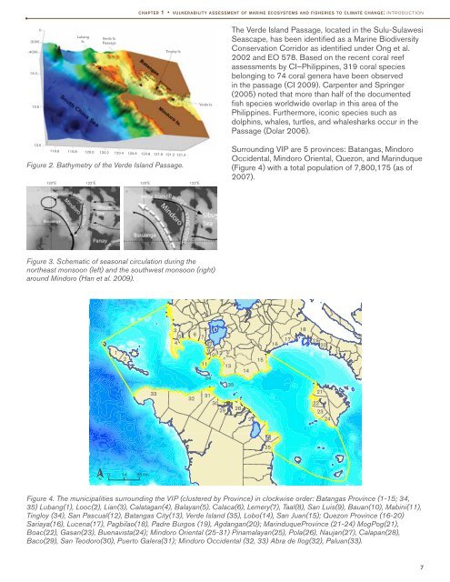
The <strong>Verde</strong> <strong>Island</strong> <strong>Passage</strong>, located in <strong>the</strong> Sulu-Sulawesi<br />
Seascape, has been identified as a Marine Biodiversity<br />
Conservation Corridor as identified under Ong et al.<br />
2002 and EO 578. Based on <strong>the</strong> recent coral reef<br />
assessments by CI–<strong>Philippines</strong>, 319 coral species<br />
belonging to 74 coral genera have been observed<br />
in <strong>the</strong> passage (CI 2009). Carpenter and Springer<br />
(2005) noted that more than half <strong>of</strong> <strong>the</strong> documented<br />
fish species worldwide overlap in this area <strong>of</strong> <strong>the</strong><br />
<strong>Philippines</strong>. Fur<strong>the</strong>rmore, iconic species such as<br />
dolphins, whales, turtles, and whalesharks occur in <strong>the</strong><br />
<strong>Passage</strong> (Dolar 2006).<br />
13.0<br />
119.6 119.8 120.0 120.2 120.4 120.6 120.8 121.0 121.2 121.4<br />
Figure 2. Bathymetry <strong>of</strong> <strong>the</strong> <strong>Verde</strong> <strong>Island</strong> <strong>Passage</strong>.<br />
120ºE 122ºE 120ºE 122ºE<br />
Surrounding VIP are 5 provinces: Batangas, Mindoro<br />
Occidental, Mindoro Oriental, Quezon, and Marinduque<br />
(Figure 4) with a total population <strong>of</strong> 7,800,175 (as <strong>of</strong><br />
2007).<br />
Figure 3. Schematic <strong>of</strong> seasonal circulation during <strong>the</strong><br />
nor<strong>the</strong>ast monsoon (left) and <strong>the</strong> southwest monsoon (right)<br />
around Mindoro (Han et al. 2009).<br />
1<br />
2<br />
33<br />
3<br />
5<br />
4<br />
32<br />
6 7<br />
8<br />
9 10 12<br />
11<br />
34<br />
31<br />
30<br />
29<br />
13<br />
35<br />
28<br />
14<br />
27<br />
15<br />
16<br />
17<br />
18<br />
19<br />
20<br />
21<br />
22<br />
23<br />
24<br />
26<br />
25<br />
N<br />
0 14 28 km<br />
Figure 4. The municipalities surrounding <strong>the</strong> VIP (clustered by Province) in clockwise order: Batangas Province (1-15; 34,<br />
35) Lubang(1), Looc(2), Lian(3), Calatagan(4), Balayan(5), Calaca(6), Lemery(7), Taal(8), San Luis(9), Bauan(10), Mabini(11),<br />
Tingloy (34), San Pascual(12), Batangas City(13), <strong>Verde</strong> <strong>Island</strong> (35), Lobo(14), San Juan(15); Quezon Province (16-20)<br />
Sariaya(16), Lucena(17), Pagbilao(18), Padre Burgos (19), Agdangan(20); MarinduqueProvince (21-24) MogPog(21),<br />
Boac(22), Gasan(23), Buenavista(24); Mindoro Oriental (25-31) Pinamalayan(25), Pola(26), Naujan(27), Calapan(28),<br />
Baco(29), San Teodoro(30), Puerto Galera(31); Mindoro Occidental (32, 33) Abra de Ilog(32), Paluan(33).<br />
7