of the Verde Island Passage, Philippines - weADAPT
of the Verde Island Passage, Philippines - weADAPT
of the Verde Island Passage, Philippines - weADAPT

You also want an ePaper? Increase the reach of your titles
YUMPU automatically turns print PDFs into web optimized ePapers that Google loves.
chapter 1 • vulnerability assessment <strong>of</strong> marine ecosystems and fisheries to climate change: sensitivity<br />
Seagrass<br />
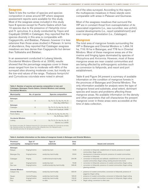
Table 5 lists <strong>the</strong> number <strong>of</strong> species and species<br />
composition in areas around VIP where seagrass<br />
assessment reports were available for this study.<br />
Most <strong>of</strong> <strong>the</strong> seagrass areas included in this study<br />
have 8 species except for Puerto Galera which has<br />
10 species due to <strong>the</strong> presence <strong>of</strong> Halophila minor<br />
and H. spinulosa. In a study conducted by Tiquio and<br />
Cayabyab (2008) in Calatagan, <strong>the</strong>y reported that <strong>the</strong><br />
species diversity in this area is comparable with<br />
Cagayancillo, and Balabac, Palawan, however it is less<br />
extensive than those areas studied in Palawan. In terms<br />
<strong>of</strong> abundance, <strong>the</strong>y reported that Calatagan seagrass<br />
meadows are less dense than Cagayancillo but denser<br />
than Tubbataha and Balabac.<br />
In an assessment conducted in Lubang <strong>Island</strong>s,<br />
Occidental Mindoro (Genito et al. 2009), results<br />
showed that <strong>the</strong> percentage seagrass cover in <strong>the</strong>se<br />
areas ranged from low to moderate with 46% <strong>of</strong> <strong>the</strong><br />
surveyed sites showing moderate cover, but mostly on<br />
<strong>the</strong> low-end values <strong>of</strong> <strong>the</strong> range. Thalassia hemprichii<br />
and Cymodocea rotundata were noted in almost<br />
Table 5. Number <strong>of</strong> species and species composition in Lian and<br />
Calatagan, Batangas; Puerto Galera, Oriental Mindoro; and Lubang,<br />
Occidental Mindoro.<br />
Municipality No. <strong>of</strong> species Species composition<br />
Batangas<br />
Lian<br />
Batangas<br />
Calatagan<br />
Oriental Mindoro<br />
Puerto Galera<br />
Occidental Mindoro<br />
Lubang<br />
8<br />
8<br />
10<br />
8<br />
Ea, Th, Cr, Cs, Hp, Hu, Ho, Si<br />
(Talim Bay CRM Plan)<br />
Ea, Th, Cr, Cs, Hp, Hu, Ho, Si<br />
(Tiquio and Cayabyab, 2008)<br />
Ea, Th, Cr, Cs, Hp, Hu, Hm, Ho,<br />
Hs, Si (Fortes, 1997)<br />
Ea, Th, Cr, Cs, Hp, Hu, Ho, Si<br />
(Genito et al, 2009)<br />
all <strong>of</strong> <strong>the</strong> sites surveyed. According to this report,<br />
<strong>the</strong> multispecies meadows in <strong>the</strong>se islands were<br />
comparable with areas in Palawan and Guimaras.<br />
Most <strong>of</strong> <strong>the</strong> seagrass meadows that surround <strong>the</strong><br />
VIP are in constant threat from overexploitation <strong>of</strong> its<br />
associated organisms (i.e., sea cucumber, sea urchin),<br />
coastal developments (i.e., resort establishment) and<br />
even mangrove afforestation (i.e., Calatagan).<br />
Mangrove<br />
The total area <strong>of</strong> mangrove forests surrounding <strong>the</strong><br />
VIP in Batangas and Oriental Mindoro is 1,494.16<br />
ha, 716.16 ha in Batangas, and 778 ha in Oriental<br />
Mindoro. Most <strong>of</strong> <strong>the</strong>se mangrove areas are <strong>of</strong> <strong>the</strong><br />
riverine and fringing types dominated by species <strong>of</strong><br />
Rhizophora and Avicennia. However, most <strong>of</strong> <strong>the</strong>se<br />
mangrove areas are near coastal communities and<br />
are being affected by anthropogenic activities such<br />
as conversion to fishponds, and resort and port<br />
establishment.<br />
Table 6 and Figure 34 present a summary <strong>of</strong> available<br />
information on <strong>the</strong> condition <strong>of</strong> mangrove forests in<br />
<strong>the</strong> provinces <strong>of</strong> Batangas and Oriental Mindoro. The<br />
only information available for analysis were <strong>the</strong> type <strong>of</strong><br />
mangrove forest and substrate, areal extent, dominant<br />
species and issues and problems affecting <strong>the</strong>se<br />
mangrove areas. No available information on <strong>the</strong> density<br />
and o<strong>the</strong>r parameters that will characterize <strong>the</strong> present<br />
mangrove cover in <strong>the</strong>se areas were accessible at <strong>the</strong><br />
time <strong>of</strong> data collection.<br />
Ea–Enhalus acoroides, Th–Thalassia hemprichii, Cr–Cymodocea rotundata, Cs–Cymodocea serrulata,<br />
Hp–Halodule pinifolia, Hu–Halodule uninervis, Hm–Halophila minor, Ho–Halophila ovalis,<br />
Hs–Halophila spinulosa, Si–Syringodium isoetifolium<br />
Table 6. Available information on <strong>the</strong> status <strong>of</strong> mangrove forests in Batangas and Oriental Mindoro.<br />
Province/ Type <strong>of</strong> Type <strong>of</strong> Area<br />
municipality mangrove forest substrate (ha) Issues and concerns<br />
Batangas<br />
Balayan<br />
Batangas City<br />
Calatagan<br />
Lian<br />
San Juan<br />
Oriental Mindoro<br />
Calapan City<br />
Naujan<br />
Baco<br />
Pola<br />
fringing/riverine<br />
fringing/riverine<br />
fringing<br />
fringing/riverine<br />
fringing/riverine<br />
riverine/fringing<br />
riverine/fringing<br />
fringing/riverine<br />
no data<br />
sandy/clay loam<br />
sandy/clay loam/muddy<br />
coralline/stony/rocky/muddy<br />
sandy/clay loam<br />
coralline/sandy/clay loam/muddy<br />
sandy/clay loam/muddy<br />
sandy/clay loam/muddy<br />
sandy/clay loam/muddy<br />
no data<br />
19.09<br />
23.64<br />
244.98<br />
79.99<br />
348.46<br />
332.00<br />
165.00<br />
134.00<br />
147.00<br />
• conversion to fishponds; establishment <strong>of</strong> resorts; presence <strong>of</strong> coastal<br />
communities; illegal cutting<br />
• development <strong>of</strong> industries and ports; presence <strong>of</strong> coastal communities;<br />
conversion to fishponds<br />
• conversion to fishponds and saltbeds; establishment <strong>of</strong> resorts; presence <strong>of</strong><br />
coastal communities; illegal cutting; existing tenurial instruments<br />
• conversion to fishponds; presence <strong>of</strong> coastal communities; illegal cutting<br />
• conversion to fishponds; presence <strong>of</strong> coastal communities; illegal cutting;<br />
gleaning activities<br />
• presence <strong>of</strong> coastal communities; conversion to fishponds; presence <strong>of</strong><br />
piggeries; illegal cutting<br />
• presence <strong>of</strong> coastal communities; conversion to fishponds; illegal cutting<br />
• presence <strong>of</strong> coastal communities/ conversion to fishponds; illegal cutting<br />
• illegal cutting; conversion to o<strong>the</strong>r uses<br />
23