of the Verde Island Passage, Philippines - weADAPT
of the Verde Island Passage, Philippines - weADAPT
of the Verde Island Passage, Philippines - weADAPT

You also want an ePaper? Increase the reach of your titles
YUMPU automatically turns print PDFs into web optimized ePapers that Google loves.
chapter 1 • vulnerability assessment <strong>of</strong> marine ecosystems and fisheries to climate change: exposure<br />
Exacerbating features <strong>of</strong> <strong>the</strong> VIP<br />
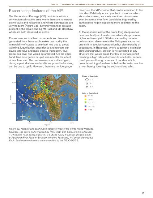
The <strong>Verde</strong> <strong>Island</strong> <strong>Passage</strong> (VIP) corridor is within a<br />
very tectonically active area where <strong>the</strong>re are numerous<br />
active faults and volcanoes and where earthquakes are<br />
very frequent (Figure 33). Several volcanoes are also<br />
present in <strong>the</strong> area including Mt. Taal and Mt. Banahaw<br />
which are both classified as active.<br />
Consequent vertical land movements and tsunamis<br />
generated from <strong>the</strong>se earthquakes can modify <strong>the</strong><br />
vulnerability <strong>of</strong> coasts to sea-level rise due to global<br />
warming. Liquefaction, subsidence and tsunami can<br />
cause extensive and rapid coastal inundation, thus,<br />
global sea-level rise would be amplified. On <strong>the</strong> o<strong>the</strong>r<br />
hand, land emergence or uplift can counter <strong>the</strong> effect<br />
<strong>of</strong> sea-level rise. The predominance <strong>of</strong> net land gain,<br />
during a period when sea level is supposed to be rising,<br />
can be due to uplift. However, <strong>the</strong>re are no tide gauge<br />
records in <strong>the</strong> VIP corridor that can be examined to test<br />
this idea. Relatively loose pyroclastic materials which<br />
abound upstream, are easily mobilized downstream<br />
even by normal river flow. Landslides triggered by<br />
earthquakes help in supplying more sediment to <strong>the</strong><br />
coast.<br />
At <strong>the</strong> upstream end <strong>of</strong> <strong>the</strong> rivers, long steep slopes<br />
have practically no forest cover, which also promotes<br />
higher sediment yield. Siltation caused by massive<br />
deforestation elsewhere in <strong>the</strong> <strong>Philippines</strong> cause not<br />
only shift in species composition but also mortality <strong>of</strong><br />
seagrasses. In Batangas, where sugarcane is a major<br />
agricultural product, erosion is not arrested by any<br />
structure that would break <strong>the</strong> flow <strong>of</strong> surface run<strong>of</strong>f<br />
resulting in high rates <strong>of</strong> erosion. In rice fields, surface<br />
run<strong>of</strong>f passes through a series <strong>of</strong> paddies which<br />
promote settling <strong>of</strong> sediments before <strong>the</strong> water reaches<br />
a river <strong>the</strong>reby lowering <strong>the</strong> sediment load a bit.<br />
Shape = Magnitude<br />
14ºN<br />
> 7<br />
5 - 7<br />
3 - 5<br />
latitude<br />
Color = Depth (km)<br />
38 - 75<br />
75 - 177<br />
13ºN<br />
117 - 154<br />
154 - 199<br />
> 199<br />
120ºE 121ºE 122ºE<br />
longitude<br />
Figure 33. Tectonic and earthquake epicenter map <strong>of</strong> <strong>the</strong> <strong>Verde</strong> <strong>Island</strong> <strong>Passage</strong><br />
Corridor. The active faults mapped by Phil. Insti. Vol. Seis. are <strong>the</strong> following:<br />
1-Philippine Fault Zone; 2-WMVF; 3-Lubang Fault; 4-Central Mindoro Fault;<br />
5-Aglubang River Fault; 6-Sou<strong>the</strong>rn Mindoro Fault; and, 7-Central Marinduque<br />
Fault. Earthquake epicenters were compiled by <strong>the</strong> NEIC-USGS.<br />
21