of the Verde Island Passage, Philippines - weADAPT
of the Verde Island Passage, Philippines - weADAPT
of the Verde Island Passage, Philippines - weADAPT

You also want an ePaper? Increase the reach of your titles
YUMPU automatically turns print PDFs into web optimized ePapers that Google loves.
climate change vulnerability assessment <strong>of</strong> <strong>the</strong> verde island passage, philippines<br />
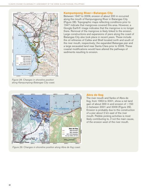
Kampumpong River—Batangas City<br />
Between 1947 to 2009, erosion <strong>of</strong> about 200 m occurred<br />
along <strong>the</strong> mouth <strong>of</strong> Kampungpong River in Batangas City<br />
(Figure 28). Topographic maps reflecting conditions prior to<br />
1947 indicate that mangroves covered this area. However, a<br />
Google Earth® image indicates that <strong>the</strong> mangrove is no longer<br />
<strong>the</strong>re. Removal <strong>of</strong> <strong>the</strong> mangrove is likely linked to <strong>the</strong> erosion.<br />
Large constructions and expansions <strong>of</strong> piers along <strong>the</strong> coast <strong>of</strong><br />
Batangas City also took place in recent years. These include<br />
<strong>the</strong> oil refineries <strong>of</strong> Caltex and Shell located north and south <strong>of</strong><br />
<strong>the</strong> river mouth, respectively; <strong>the</strong> expanded Batangas pier and<br />
a large excavated land near Santa Clara prior to 2009. These<br />
coastal modifications would have altered <strong>the</strong> pathways <strong>of</strong><br />
sediments resulting to erosion.<br />
Figure 28. Changes in shoreline position<br />
along Kampumpong-Batangas City coast.<br />
Abra de Ilog<br />
The river mouth and flanks <strong>of</strong> Abra de<br />
Ilog, from 1953 to 2001, show a net land<br />
gain <strong>of</strong> about 300 m and erosion <strong>of</strong> ~150<br />
m between 2001 and 2009 (Figure 29).<br />
Erosion is probably due to <strong>the</strong> construction<br />
<strong>of</strong> a pier about 2 km east <strong>of</strong> <strong>the</strong> river<br />
mouth. Pebble picking activities is most<br />
likely contributing to, if not <strong>the</strong> main cause,<br />
<strong>of</strong> <strong>the</strong> erosion west <strong>of</strong> <strong>the</strong> river mouth.<br />
Figure 29. Changes in shoreline position along Abra de Ilog coast.<br />
18