of the Verde Island Passage, Philippines - weADAPT
of the Verde Island Passage, Philippines - weADAPT
of the Verde Island Passage, Philippines - weADAPT

Create successful ePaper yourself
Turn your PDF publications into a flip-book with our unique Google optimized e-Paper software.
chapter 2 • human well-being and climate change: results and discussion<br />
on health and food safety are <strong>the</strong> least recognized.<br />
Hence, with <strong>the</strong> focus on human health and safety<br />
in <strong>the</strong> coastal environment, vulnerability indicators<br />
recommended include <strong>the</strong> following:<br />
• flood-prone area;<br />
• climate change effects on health and diseases that<br />
are water-, vector-, rodent- and food-borne as well<br />
as extreme temperature-related; and,<br />
• climate change-ready physical infrastructure for<br />
disaster and risk management and ecosystembased<br />
water supply system (distribution), drainage<br />
and sanitation.<br />
i. Flood-prone area: VULNERABLE<br />
A Flood-prone Index with scores from 1=Low,<br />
2=Medium, 3=High vulnerability is a suggested tool.<br />
As a case study, flood prone areas in all municipalities<br />
on <strong>the</strong> Batangas side <strong>of</strong> <strong>the</strong> <strong>Verde</strong> <strong>Island</strong> <strong>Passage</strong> that<br />
host hundreds <strong>of</strong> thousands <strong>of</strong> people are categorized<br />
into <strong>the</strong> following:<br />
• Category 1: Almost flooded as a result <strong>of</strong> heavy<br />
rains aggravated by high tide or rise in water level or<br />
nearby seas, lakes, rivers, etc.<br />
• Category 2: Flooded only after several days <strong>of</strong><br />
heavy and continuous rains with subsequent rise in<br />
water level or lakes, seas, dikes, rivers and canals<br />
• Category 3: Flooded only after several days <strong>of</strong><br />
exceptionally heavy or continuous rains.<br />
• Category 4: Never experienced flood but present<br />
environmental condition in <strong>the</strong> area warrant LGU’s<br />
concern on flood, flash flood, land slides and mud<br />
slides.<br />
• Category 5: Residential areas, national and<br />
provincial road networks prone to landslide and<br />
mudslides.<br />
or town center, as basis <strong>of</strong> Flood-prone Index A with<br />
scores from 1=Low, 2=Medium, 3=High vulnerability.<br />
Flood-prone Index A was customized to rank<br />
municipalities where <strong>the</strong>y are most vulnerable to<br />
flooding under Category 1 and 2 only (rains with<br />
subsequent rise in sea water level or near seas, dikes<br />
o<strong>the</strong>r waterways in coastal areas). The following<br />
among <strong>the</strong> province-wide Batangas side <strong>of</strong> <strong>the</strong> <strong>Verde</strong><br />
<strong>Passage</strong> had <strong>the</strong> greatest number <strong>of</strong> communities and<br />
population exposed to floods aggravated by water level<br />
rise: Nasugbu (37 out <strong>of</strong> 42 barangays) and Calatagan<br />
(20 out <strong>of</strong> 25 barangays) with a vulnerability rating <strong>of</strong><br />
3 (high), followed by Lian (10 <strong>of</strong> 19), Bauan (16 out <strong>of</strong><br />
40) and Lemery (18 out <strong>of</strong> 46 barangays) with a rating<br />
<strong>of</strong> 2 (medium).<br />
Focusing on only <strong>the</strong> coastal areas in <strong>the</strong>se<br />
municipalities to emphasize marine adaptation to<br />
climate change, an adjusted Flood-prone Index B (only<br />
for <strong>the</strong> scaled down area) gives Calatagan and Tingloy<br />
(for its size) a score <strong>of</strong> 3 (Table 60). They are highly<br />
vulnerable to flooding where it is most likely to happen<br />
and where <strong>the</strong>y have <strong>the</strong> greatest number <strong>of</strong> coastal<br />
barangays, although Calatagan, Nasugbu, Lemery and<br />
San Juan have <strong>the</strong> largest exposed population.<br />
Testing <strong>the</strong> use <strong>of</strong> <strong>the</strong> Flood-prone Index in <strong>the</strong> rest <strong>of</strong><br />
<strong>Verde</strong> <strong>Island</strong> <strong>Passage</strong> provinces would be beneficial to<br />
expand <strong>the</strong> vulnerability assessment.<br />
This scale indicates vulnerability ranges from highest<br />
(Category 1) to lowest (Category 4 and 5). Table<br />
59 summarizes <strong>the</strong> vulnerable population across all<br />
barangays, whe<strong>the</strong>r located in <strong>the</strong> interior sections<br />
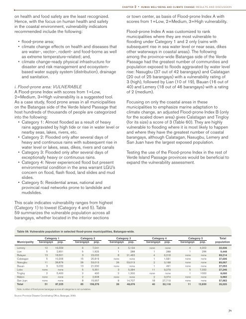
Table 59. Vulnerable population in selected flood-prone municipalities, Batangas-wide.<br />
Category 1 Category 2 Category 3 Category 4 Category 5 Total<br />
Municipality barangays pop. barangays pop. barangays pop. barangays pop. barangays pop. population<br />
Lemery<br />
Lian<br />
Balayan<br />
Calatagan<br />
Nasugbu<br />
Bauan<br />
Lobo<br />
Tingloy<br />
Mabini<br />
San Juan<br />
Total<br />
12<br />
5<br />
13<br />
5<br />
11<br />
3<br />
none<br />
2<br />
none<br />
none<br />
51<br />
16,559<br />
2,651<br />
18,501<br />
10,206<br />
28,876<br />
5,032<br />
none<br />
5,400<br />
none<br />
none<br />
87,225<br />
6<br />
5<br />
3<br />
15<br />
26<br />
13<br />
5<br />
2<br />
2<br />
8<br />
85<br />
7,041<br />
1,925<br />
23,032<br />
25,819<br />
53,013<br />
21,530<br />
5,351<br />
400<br />
2,608<br />
15,557<br />
156,276<br />
4<br />
1<br />
8<br />
none<br />
26<br />
none<br />
3<br />
2<br />
none<br />
8<br />
26<br />
5,134<br />
288<br />
21,463<br />
none<br />
53,013<br />
none<br />
5,284<br />
1,200<br />
none<br />
14,707<br />
48,076<br />
none<br />
1<br />
4<br />
1<br />
2<br />
1<br />
11<br />
none<br />
2<br />
18<br />
40<br />
none<br />
288<br />
6,218<br />
1,581<br />
3,168<br />
491<br />
9,279<br />
none<br />
3,374<br />
27,719<br />
52,118<br />
4<br />
1<br />
none<br />
none<br />
none<br />
none<br />
5<br />
1<br />
none<br />
none<br />
11<br />
4,202<br />
296<br />
none<br />
none<br />
none<br />
none<br />
7,332<br />
1000<br />
none<br />
none<br />
12,830<br />
32,936<br />
5,448<br />
69,214<br />
37,606<br />
85,057<br />
27,053<br />
27,246<br />
8,000<br />
5,982<br />
57,983<br />
35,525<br />
Note: number <strong>of</strong> flood-prone barangays across all categories is not cumulative.<br />
Source: Provincial Disaster Coordinating Office, Batangas, 2009.<br />
71