of the Verde Island Passage, Philippines - weADAPT
of the Verde Island Passage, Philippines - weADAPT
of the Verde Island Passage, Philippines - weADAPT

You also want an ePaper? Increase the reach of your titles
YUMPU automatically turns print PDFs into web optimized ePapers that Google loves.
chapter 1 • vulnerability assessment <strong>of</strong> marine ecosystems and fisheries to climate change: sensitivity<br />
meadows are more exposed to extreme temperatures<br />
than meadows in temperate region, <strong>the</strong> photosyn<strong>the</strong>tic<br />
responses <strong>of</strong> most seagrass species (as shown in this<br />
article)may likely suffer from short term or episodic<br />
exposure to seawater temperature ranging from 40<br />
to 45°C. Of <strong>the</strong> species studied by Campbell et al.<br />
(2006), Cymodocea rotundata, C. serrulata, Halodule<br />
uninervis, and Thalassia hemprichii were more tolerant<br />
to <strong>the</strong>rmal stress than o<strong>the</strong>r species. Using this study<br />
to determine <strong>the</strong> sensitivity <strong>of</strong> seagrasses in areas that<br />
surround VIP to increasing SST, <strong>the</strong> four areas included<br />
in this report may be least sensitive to increase in SST<br />
due to <strong>the</strong> presence <strong>of</strong> species which are tolerant to<br />
<strong>the</strong>rmal stress (Table 5), however, this projection may<br />
fur<strong>the</strong>r be refined when available data on seagrass<br />
densities and zonation <strong>of</strong> species will be considered.<br />
Of <strong>the</strong> two habitats assessed to be sensitive to<br />
increase in temperature, corals are deemed more<br />
sensitive. Indeed globally, documentations <strong>of</strong> positive<br />
sea surface temperature (SST) anomalies have been<br />
associated with mass coral bleaching, mortality<br />
(Hoegh-Guldberg 1999, Wilkinson 2004), and coral<br />
disease outbreak (Bruno et al. 2007).<br />
Storm impact<br />
Coral<br />
Analysis <strong>of</strong> <strong>the</strong> impacts <strong>of</strong> typhoons was based on <strong>the</strong><br />
study by Licuanan (unpublished report) in Pagbilao,<br />
Quezon. Based on <strong>the</strong> monitoring <strong>of</strong> reefs in Pagbilao,<br />
Quezon (just to <strong>the</strong> east <strong>of</strong> <strong>the</strong> VIP) estimated coral<br />
cover losses during tropical storm Caloy was 12.5%<br />
for sheltered sites and 37.5% for exposed sites. These<br />
estimates were <strong>the</strong>n used to calculate <strong>the</strong> change <strong>of</strong> <strong>the</strong><br />
percentage coral cover during low to severe impacts<br />
since no function relating storm strength and cover<br />
loss is available. Coral cover in Quezon is comparable<br />
to <strong>the</strong> sites in <strong>the</strong> VIP, as are <strong>the</strong> reefs—which are<br />
generally narrow fringing type. Both areas are within <strong>the</strong><br />
<strong>Philippines</strong>’ typhoon belt.<br />
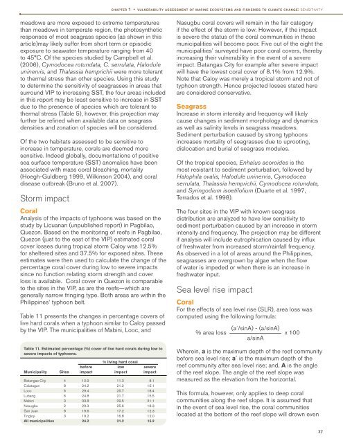
Table 11 presents <strong>the</strong> changes in percentage covers <strong>of</strong><br />
live hard corals when a typhoon similar to Caloy passed<br />
by <strong>the</strong> VIP. The municipalities <strong>of</strong> Mabini, Looc, and<br />
Table 11. Estimated percentage (%) cover <strong>of</strong> live hard corals during low to<br />
severe impacts <strong>of</strong> typhoons.<br />
% living hard coral<br />
before low severe<br />
Municipality Sites impact impact impact<br />
Batangas City<br />
Calatagan<br />
Looc<br />
Lubang<br />
Mabini<br />
Nasugbu<br />
San Juan<br />
Tingloy<br />
All municipalities<br />
4<br />
8<br />
6<br />
6<br />
3<br />
2<br />
8<br />
3<br />
12.9<br />
24.2<br />
29.4<br />
24.8<br />
33.8<br />
29.3<br />
19.6<br />
19.2<br />
24.2<br />
11.3<br />
21.2<br />
25.7<br />
21.7<br />
29.5<br />
25.6<br />
17.2<br />
16.8<br />
21.2<br />
8.1<br />
15.1<br />
18.4<br />
15.5<br />
21.1<br />
18.3<br />
12.3<br />
12.0<br />
15.2<br />
Nasugbu coral covers will remain in <strong>the</strong> fair category<br />
if <strong>the</strong> effect <strong>of</strong> <strong>the</strong> storm is low. However, if <strong>the</strong> impact<br />
is severe <strong>the</strong> status <strong>of</strong> <strong>the</strong> coral communities in <strong>the</strong>se<br />
municipalities will become poor. Five out <strong>of</strong> <strong>the</strong> eight <strong>the</strong><br />
municipalities’ surveyed have poor coral covers, <strong>the</strong>reby<br />
increasing <strong>the</strong>ir vulnerability in <strong>the</strong> event <strong>of</strong> a severe<br />
impact. Batangas City for example after severe impact<br />
will have <strong>the</strong> lowest coral cover <strong>of</strong> 8.1% from 12.9%.<br />
Note that Caloy was merely a tropical storm and not <strong>of</strong><br />
typhoon strength. Hence projected losses stated here<br />
are considered conservative.<br />
Seagrass<br />
Increase in storm intensity and frequency will likely<br />
cause changes in sediment morphology and dynamics<br />
as well as salinity levels in seagrass meadows.<br />
Sediment perturbation caused by strong typhoons<br />
increases mortality <strong>of</strong> seagrasses due to uprooting,<br />
dislocation and burial <strong>of</strong> seagrass modules.<br />
Of <strong>the</strong> tropical species, Enhalus acoroides is <strong>the</strong><br />
most resistant to sediment perturbation, followed by<br />
Halophila ovalis, Halodule uninervis, Cymodocea<br />
serrulata, Thalassia hemprichii, Cymodocea rotundata,<br />
and Syringodium isoetifolium (Duarte et al. 1997,<br />
Terrados et al. 1998).<br />
The four sites in <strong>the</strong> VIP with known seagrass<br />
distribution are analyzed to have low sensitivity to<br />
sediment perturbation caused by an increase in storm<br />
intensity and frequency. The projection may be different<br />
if analysis will include eutrophication caused by influx<br />
<strong>of</strong> freshwater from increased storm/rainfall frequency.<br />
As observed in a lot <strong>of</strong> areas around <strong>the</strong> <strong>Philippines</strong>,<br />
seagrasses are overgrown by algae when <strong>the</strong> flow<br />
<strong>of</strong> water is impeded or when <strong>the</strong>re is an increase in<br />
freshwater input.<br />
Sea level rise impact<br />
Coral<br />
For <strong>the</strong> effects <strong>of</strong> sea level rise (SLR), area loss was<br />
computed using <strong>the</strong> following formula:<br />
% area loss<br />
(a´/sinA) - (a/sinA)<br />
a/sinA<br />
x 100<br />
Wherein, a is <strong>the</strong> maximum depth <strong>of</strong> <strong>the</strong> reef community<br />
before sea level rise; a´ is <strong>the</strong> maximum depth <strong>of</strong> <strong>the</strong><br />
reef community after sea level rise; and, A is <strong>the</strong> angle<br />
<strong>of</strong> <strong>the</strong> reef slope. The angle <strong>of</strong> <strong>the</strong> reef slope was<br />
measured as <strong>the</strong> elevation from <strong>the</strong> horizontal.<br />
This formula, however, only applies to deep coral<br />
communities along <strong>the</strong> reef slope. It is assumed that<br />
in <strong>the</strong> event <strong>of</strong> sea level rise, <strong>the</strong> coral communities<br />
located at <strong>the</strong> bottom <strong>of</strong> <strong>the</strong> reef slope will drown even<br />
27