of the Verde Island Passage, Philippines - weADAPT
of the Verde Island Passage, Philippines - weADAPT
of the Verde Island Passage, Philippines - weADAPT

You also want an ePaper? Increase the reach of your titles
YUMPU automatically turns print PDFs into web optimized ePapers that Google loves.
chapter 1 • vulnerability assessment <strong>of</strong> marine ecosystems and fisheries to climate change: exposure<br />
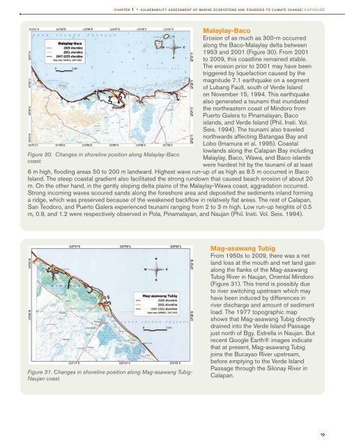
Figure 30. Changes in shoreline position along Malaylay-Baco<br />
coast.<br />
Malaylay-Baco<br />
Erosion <strong>of</strong> as much as 300-m occurred<br />
along <strong>the</strong> Baco-Malaylay delta between<br />
1953 and 2001 (Figure 30). From 2001<br />
to 2009, this coastline remained stable.<br />
The erosion prior to 2001 may have been<br />
triggered by liquefaction caused by <strong>the</strong><br />
magnitude 7.1 earthquake on a segment<br />
<strong>of</strong> Lubang Fault, south <strong>of</strong> <strong>Verde</strong> <strong>Island</strong><br />
on November 15, 1994. This earthquake<br />
also generated a tsunami that inundated<br />
<strong>the</strong> nor<strong>the</strong>astern coast <strong>of</strong> Mindoro from<br />
Puerto Galera to Pinamalayan, Baco<br />
islands, and <strong>Verde</strong> <strong>Island</strong> (Phil. Insti. Vol.<br />
Seis. 1994). The tsunami also traveled<br />
northwards affecting Batangas Bay and<br />
Lobo (Imamura et al. 1995). Coastal<br />
lowlands along <strong>the</strong> Calapan Bay including<br />
Malaylay, Baco, Wawa, and Baco islands<br />
were hardest hit by <strong>the</strong> tsunami <strong>of</strong> at least<br />
6 m high, flooding areas 50 to 200 m landward. Highest wave run-up <strong>of</strong> as high as 8.5 m occurred in Baco<br />
<strong>Island</strong>. The steep coastal gradient also facilitated <strong>the</strong> strong rundown that caused beach erosion <strong>of</strong> about 20<br />
m. On <strong>the</strong> o<strong>the</strong>r hand, in <strong>the</strong> gently sloping delta plains <strong>of</strong> <strong>the</strong> Malaylay-Wawa coast, aggradation occurred.<br />
Strong incoming waves scoured sands along <strong>the</strong> foreshore area and deposited <strong>the</strong> sediments inland forming<br />
a ridge, which was preserved because <strong>of</strong> <strong>the</strong> weakened backflow in relatively flat areas. The rest <strong>of</strong> Calapan,<br />
San Teodoro, and Puerto Galera experienced tsunami ranging from 2 to 3 m high. Low run-up heights <strong>of</strong> 0.5<br />
m, 0.9, and 1.2 were respectively observed in Pola, Pinamalayan, and Naujan (Phil. Insti. Vol. Seis. 1994).<br />
Figure 31. Changes in shoreline position along Mag-asawang Tubig-<br />
Naujan coast.<br />
Mag-asawang Tubig<br />
From 1950s to 2009, <strong>the</strong>re was a net<br />
land loss at <strong>the</strong> mouth and net land gain<br />
along <strong>the</strong> flanks <strong>of</strong> <strong>the</strong> Mag-asawang<br />
Tubig River in Naujan, Oriental Mindoro<br />
(Figure 31). This trend is possibly due<br />
to river switching upstream which may<br />
have been induced by differences in<br />
river discharge and amount <strong>of</strong> sediment<br />
load. The 1977 topographic map<br />
shows that Mag-asawang Tubig directly<br />
drained into <strong>the</strong> <strong>Verde</strong> <strong>Island</strong> <strong>Passage</strong><br />
just north <strong>of</strong> Bgy. Estrella in Naujan. But<br />
recent Google Earth® images indicate<br />
that at present, Mag-asawang Tubig<br />
joins <strong>the</strong> Bucayao River upstream,<br />
before emptying to <strong>the</strong> <strong>Verde</strong> <strong>Island</strong><br />
<strong>Passage</strong> through <strong>the</strong> Silonay River in<br />
Calapan.<br />
19