- Page 1:
Jurassic Coast Transport Infrastruc
- Page 5:
Contents1 Introduction 11.1 Backgro
- Page 9:
authorities (LPAs) - East Devon, Pu
- Page 21 and 22:
Table 2.2: Selected planning polici
- Page 23:
2.5.4 Most of the study area has de
- Page 28 and 29:
Table 2.3: Potential car bus interc
- Page 30 and 31:
a1) Existing public car parks2.6.2
- Page 32:
- Land at Bowd Cross, between Newto
- Page 41:
2.6.17 Two sites have been identifi
- Page 48 and 49:
operate during summer weekends only
- Page 50 and 51:
Figure 2.16: Breeze Up To The Downs
- Page 52 and 53:
Table 3.1 Appropriateness of bus se
- Page 54 and 55:
Table 3.2 Existing bus provision to
- Page 56 and 57:
3.2 Fin dings3.2.1 The majority of
- Page 58 and 59:
service, but the holiday park is 86
- Page 60 and 61:
3.4.13 As an alternative to combini
- Page 62 and 63:
3.6.3 Inconsistencies with NaPTAN d
- Page 64 and 65:
3.7 Strategy Measure D: Enhan ce ro
- Page 66 and 67:
3.9.2 Of the sites that are not wel
- Page 68 and 69:
4 Demand Responsive Transport Servi
- Page 70 and 71:
ather more than that - £10 per tri
- Page 72 and 73:
complicated timetable or a lack of
- Page 74 and 75:
Figure 4.3: D2D Service 103 instruc
- Page 76 and 77:
highlights that the f lexib le DRT
- Page 78 and 79:
4.7.9 Whilst local residents using
- Page 80 and 81:
4.9.3 Potential users may not be co
- Page 82 and 83:
that DRT are comp licated by their
- Page 84 and 85:
Figure 4.5 and 4.6 - The home page
- Page 86 and 87:
etween Charmouth and Symondsbury an
- Page 88 and 89:
4.14 Summary an d Recommen dations4
- Page 90 and 91:
Service understanding- Ensure that
- Page 92 and 93:
Joint working- DoCC should work clo
- Page 94 and 95: 5.2.3 The appraisal methodology loo
- Page 97 and 98: 5.3.6 The incumbent train operating
- Page 99 and 100: connections are in place (especiall
- Page 101 and 102: Figures 5.2 to 5.5:Axminster Railwa
- Page 103 and 104: Figures 5.8 to 5.12Axminster Railwa
- Page 105 and 106: Figure 5.15Axminster Railway Statio
- Page 108 and 109: 5.4.5 Neither the bus nor rail time
- Page 110: wait at Honiton. As at Axminster, h
- Page 113 and 114: Figures 5.24 to 5.25Honiton Railway
- Page 115 and 116: The road underneath the station has
- Page 117: 5.5 Exmouth Railw ay StationIntrodu
- Page 120 and 121: fairly good signage. There is a pub
- Page 122 and 123: Figures 5.39 to 5.42Exmouth Railway
- Page 124 and 125: The stepped entrance to the ticket
- Page 126 and 127: Figures 5.54 to 5.55Exmouth Railway
- Page 128 and 129: Table 5.2 Rail-Bus Interchange Audi
- Page 130 and 131: 6 Presenting Public Transport Infor
- Page 132 and 133: 6.3 Con ven tion al at-stop in form
- Page 134 and 135: 6.3.6 At-stop bus information in th
- Page 136 and 137: and to change the relevant timetabl
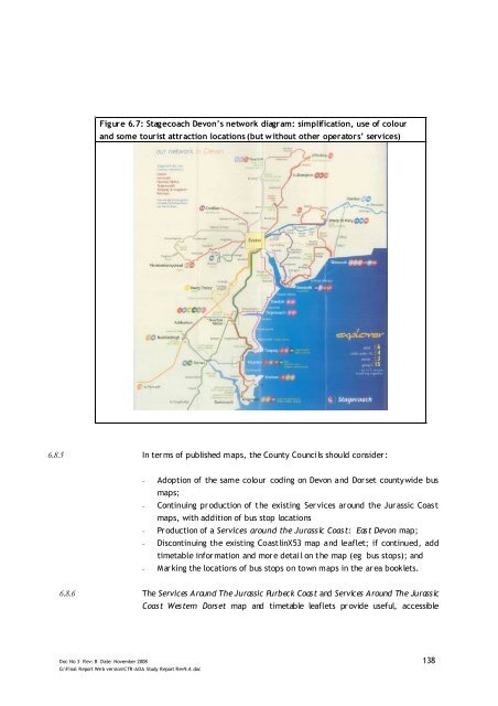
- Page 138 and 139: attractions and accommodation sites
- Page 140 and 141: 6.7.7 Operators and local authoriti
- Page 142 and 143: 6.7.13 Service 40 operates a simple
- Page 146 and 147: information for visitors. These cou
- Page 148 and 149: 6.9.7 A certain amount of pro-activ
- Page 150 and 151: and timetable information, whereas
- Page 152 and 153: Figure 6.10: Stop-specific timetabl
- Page 154 and 155: effective partnership between the b
- Page 156 and 157: close working between the three mai
- Page 158 and 159: 6.12.7 Whilst various circumstances
- Page 160 and 161: 6.16 Summary & Recommendations6.16.
- Page 162 and 163: 7 Partnership working7.1 In troduct
- Page 164 and 165: of different organisations involved
- Page 166 and 167: 8.1.5 Although it is unrealistic to
- Page 168 and 169: 8.1.14 Although RTPI systems are ex
- Page 170 and 171: WDDCWDLPWest Dorset District Counci
- Page 172 and 173: Appendices
- Page 174 and 175: Appendix A: Detailed information on
- Page 176 and 177: FleetChicker ellWeymouth(Wyke Regis
- Page 179 and 180: Appendix BBus Stop Access Audit
- Page 181 and 182: IssuesTraffic speed or volume? No f
- Page 183 and 184: Appendix C: Types of Demand Respons
- Page 185 and 186: unfamiliar with it. Given that maki
- Page 187 and 188: Passenger feedbackAs detailed passe
- Page 189: • Are the connecting bus services