Jurassic Coast Transport Infrastructure Gap Analysis Study
Jurassic Coast Transport Infrastructure Gap Analysis Study
Jurassic Coast Transport Infrastructure Gap Analysis Study
- No tags were found...

You also want an ePaper? Increase the reach of your titles
YUMPU automatically turns print PDFs into web optimized ePapers that Google loves.
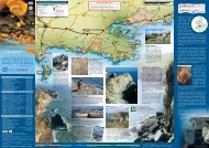
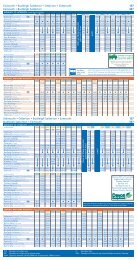
3 Bus services to serve camping andcaravan sites3.1 Meth odology3.1.1 Information on camping and caravan site locations was taken from the 2008<strong>Jurassic</strong> <strong>Coast</strong> public transport publications, the relevant Ordnance Surveymaps and holiday accommodation websites. Bus stop locations were plottedon the GIS program MapInfo from the National Public <strong>Transport</strong> AccessibilityNode (NaPTAN) database (dated January 2008) and bus service frequencieswere taken from the relevant County Council 2008 public transportpublications.3.1.2 Information has been gathered about the closest bus service excepting whereother, more frequent, bus services are accessible slightly f urther away. Inthese cases, information is provided on services at both locations. Buses whichrun on certain days of the week only have not been includ ed unless they arethe only availab le bus service. Some bus services are more frequent duringsummer months and where this is the case it has been noted. Summerfrequencies have been used for assessment purposes as it is assumed thatcamping and caravan sites have highest occupancy and demand for publictransport will be highest at these times.3.1.3 The following factors were used to assess the appropriateness of bus services,as follows:- Size of camping or caravan site (in terms of pitches, etc) (small, medium,large);- Distance to b us stops (Categories 1 to 4 depending on distance); and- Frequency of bus services (Categories 1 to 4 depending on frequency).The rationale is that certain sites may be too far from bus stops or not havefrequent enough bus services for the number of visitors they accommodate.3.1.4 The criteria for the categories are set out in Table 3.1 below. Colour coding isused to highlight those sites that are relatively inaccessible by bus (in gradesof yellow and red).Doc No 3 Rev: B Date: November 2008 44G:\Final Report Web version\CTR-ADA <strong>Study</strong> Report Rev9.4. doc