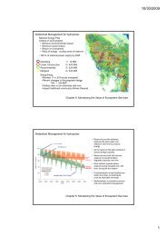
RAINFOR GEM Intensive Plots Manual (pdf) - University of Oxford
RAINFOR GEM Intensive Plots Manual (pdf) - University of Oxford
RAINFOR GEM Intensive Plots Manual (pdf) - University of Oxford
- No tags were found...

Create successful ePaper yourself
Turn your PDF publications into a flip-book with our unique Google optimized e-Paper software.
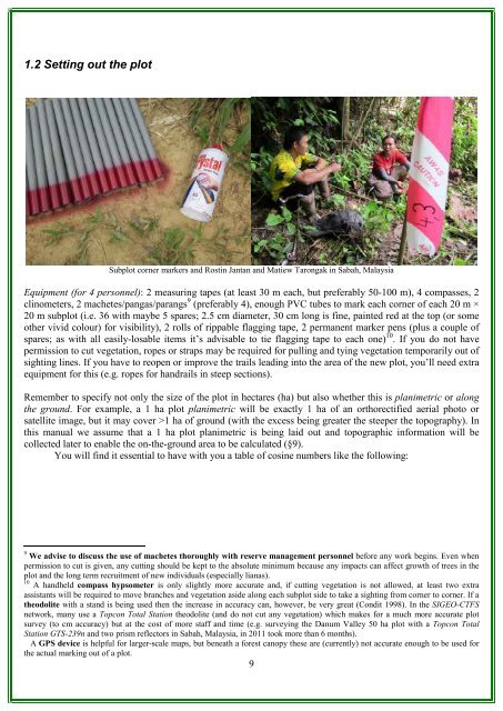
1.2 Setting out the plotSubplot corner markers and Rostin Jantan and Matiew Tarongak in Sabah, MalaysiaEquipment (for 4 personnel): 2 measuring tapes (at least 30 m each, but preferably 50-100 m), 4 compasses, 2clinometers, 2 machetes/pangas/parangs 9 (preferably 4), enough PVC tubes to mark each corner <strong>of</strong> each 20 m ×20 m subplot (i.e. 36 with maybe 5 spares; 2.5 cm diameter, 30 cm long is fine, painted red at the top (or someother vivid colour) for visibility), 2 rolls <strong>of</strong> rippable flagging tape, 2 permanent marker pens (plus a couple <strong>of</strong>spares; as with all easily-losable items it’s advisable to tie flagging tape to each one) 10 . If you do not havepermission to cut vegetation, ropes or straps may be required for pulling and tying vegetation temporarily out <strong>of</strong>sighting lines. If you have to reopen or improve the trails leading into the area <strong>of</strong> the new plot, you’ll need extraequipment for this (e.g. ropes for handrails in steep sections).Remember to specify not only the size <strong>of</strong> the plot in hectares (ha) but also whether this is planimetric or alongthe ground. For example, a 1 ha plot planimetric will be exactly 1 ha <strong>of</strong> an orthorectified aerial photo orsatellite image, but it may cover >1 ha <strong>of</strong> ground (with the excess being greater the steeper the topography). Inthis manual we assume that a 1 ha plot planimetric is being laid out and topographic information will becollected later to enable the on-the-ground area to be calculated (§9).You will find it essential to have with you a table <strong>of</strong> cosine numbers like the following:9 We advise to discuss the use <strong>of</strong> machetes thoroughly with reserve management personnel before any work begins. Even whenpermission to cut is given, any cutting should be kept to the absolute minimum because any impacts can affect growth <strong>of</strong> trees in theplot and the long term recruitment <strong>of</strong> new individuals (especially lianas).10 A handheld compass hypsometer is only slightly more accurate and, if cutting vegetation is not allowed, at least two extraassistants will be required to move branches and vegetation aside along each subplot side to take a sighting from corner to corner. If atheodolite with a stand is being used then the increase in accuracy can, however, be very great (Condit 1998). In the SIGEO-CTFSnetwork, many use a Topcon Total Station theodolite (and do not cut any vegetation) which makes for a much more accurate plotsurvey (to cm accuracy) but at the cost <strong>of</strong> more staff and time (e.g. surveying the Danum Valley 50 ha plot with a Topcon TotalStation GTS-239n and two prism reflectors in Sabah, Malaysia, in 2011 took more than 6 months).A GPS device is helpful for larger-scale maps, but beneath a forest canopy these are (currently) not accurate enough to be used forthe actual marking out <strong>of</strong> a plot.9