RAINFOR GEM Intensive Plots Manual (pdf) - University of Oxford
RAINFOR GEM Intensive Plots Manual (pdf) - University of Oxford
RAINFOR GEM Intensive Plots Manual (pdf) - University of Oxford
- No tags were found...

Create successful ePaper yourself
Turn your PDF publications into a flip-book with our unique Google optimized e-Paper software.
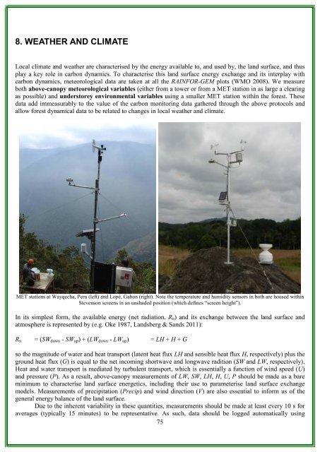
8. WEATHER AND CLIMATELocal climate and weather are characterised by the energy available to, and used by, the land surface, and thusplay a key role in carbon dynamics. To characterise this land surface energy exchange and its interplay withcarbon dynamics, meteorological data are taken at all the <strong>RAINFOR</strong>-<strong>GEM</strong> plots (WMO 2008). We measureboth above-canopy meteorological variables (either from a tower or from a MET station in as large a clearingas possible) and understorey environmental variables using a smaller MET station within the forest. Thesedata add immeasurably to the value <strong>of</strong> the carbon monitoring data gathered through the above protocols andallow forest dynamical data to be related to changes in local weather and climate.MET stations at Wayqecha, Peru (left) and Lopé, Gabon (right). Note the temperature and humidity sensors in both are housed withinStevenson screens in an unshaded position (which defines “screen height”).In its simplest form, the available energy (net radiation, R n ) and its exchange between the land surface andatmosphere is represented by (e.g. Oke 1987, Landsberg & Sands 2011):R n = (SW down - SW up ) + (LW down - LW up ) = LH + H + Gso the magnitude <strong>of</strong> water and heat transport (latent heat flux LH and sensible heat flux H, respectively) plus theground heat flux (G) is equal to the net incoming shortwave and longwave radition (SW and LW, respectively).Heat and water transport is mediated by turbulent transport, which is essentially a function <strong>of</strong> wind speed (U)and pressure (P). As a result, above-canopy measurements <strong>of</strong> LW, SW, LH, H, U, P should be made as a bareminimum to characterise land surface energetics, including their use to parameterise land surface exchangemodels. Measurements <strong>of</strong> precipitation (Precip) and wind direction (V) are also essential to inform us <strong>of</strong> thegeneral energy balance <strong>of</strong> the land surface.Due to the inherent variability in these quantities, measurements should be made at least every 10 s foraverages (typically 15 minutes) to be representative. As such, data should be logged automatically using75