- Page 1 and 2:
HARVARDUKRAINIAN STUDIESVolume XI N
- Page 4 and 5:
REVIEW ARTICLESRudnytsky's Essays i
- Page 6 and 7:
A Note from the EditorsEight of the
- Page 8 and 9:
THEOLOGY IN KIEV AN RUS 27121 July
- Page 10 and 11: THEOLOGY IN KIEV AN RUS 273a rough
- Page 12 and 13: THEOLOGY IN KIEV AN RUS 275there we
- Page 14 and 15: THEOLOGY IN KIEV AN RUS 277sacrific
- Page 16 and 17: THEOLOGY IN KIEV AN RUS 279ity with
- Page 18 and 19: THEOLOGY IN KIEV AN RUS 281nearly b
- Page 20 and 21: THEOLOGY IN KIEV AN RUS 283the floo
- Page 22 and 23: THEOLOGY IN KIEVAN RUS 285the clois
- Page 24 and 25: How the Conversion of Rus' Was Unde
- Page 26 and 27: THE CONVERSION OF RUS' 289tices amo
- Page 28 and 29: THE CONVERSION OF RUS' 291Although
- Page 30 and 31: THE CONVERSION OF RUS' 293Christian
- Page 32 and 33: THE CONVERSION OF RUS' 295Byzantine
- Page 34 and 35: THE CONVERSION OF RUS' 297gave the
- Page 36 and 37: THE CONVERSION OF RUS' 299Without d
- Page 38 and 39: THE CONVERSION OF RUS' 301emperors,
- Page 40 and 41: The Sack of Kiev of 1169:Its Signif
- Page 42 and 43: THE SACK OF KIEV OF 1169 305Oleksa
- Page 44 and 45: THE SACK OF KIEV OF 1169 307skazani
- Page 46 and 47: THE SACK OF KIEV OF 1169 309has hyp
- Page 48 and 49: THE SACK OF KIEV OF 1169 311and som
- Page 50 and 51: THE SACK OF KIEV OF 1169 313pal cen
- Page 52 and 53: THE SACK OF KIEV OF 1169 315chronic
- Page 54 and 55: Religious Sites in KievDuring the R
- Page 56 and 57: RELIGIOUS SITES IN KIEV 319fraction
- Page 58 and 59: RELIGIOUS SITES IN KIEV 321shrines
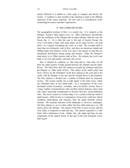
- Page 62 and 63: ARCHAEOLOGY OF KIEV 325Traditionall
- Page 64 and 65: ARCHAEOLOGY OF KIEV 327Kravcenko 19
- Page 66 and 67: ARCHAEOLOGY OF KIEV 329"foundation"
- Page 68 and 69: ARCHAEOLOGY OF KIEV 331settlement t
- Page 70 and 71: ARCHAEOLOGY OF KIEV 333more likely
- Page 72 and 73: ARCHAEOLOGY OF KIEV 335Some time in
- Page 74 and 75: ARCHAEOLOGY OF KIEV 337slopes. The
- Page 76 and 77: ARCHAEOLOGY OF KIEV 339Pocajna, it
- Page 78 and 79: ARCHAEOLOGY OF KIEV 341seems, howev
- Page 80 and 81: ARCHAEOLOGY OF KIEV 343palace build
- Page 82 and 83: ARCHAEOLOGY OF KIEV 345settlement.
- Page 84 and 85: ARCHAEOLOGY OF KIEV 347formed a lar
- Page 86 and 87: ARCHAEOLOGY OF KIEV 349of the perio
- Page 88 and 89: ARCHAEOLOGY OF KIEV 351Janin, V. L.
- Page 90 and 91: ARCHAEOLOGY OF KIEV 3531981D. "Mass
- Page 92 and 93: ARCHAEOLOGY OF KIEV355Fig. 2Topogra
- Page 94 and 95: ARCHAEOLOGY OF KIEV357Fig. 4The kap
- Page 96 and 97: ARCHAEOLOGY OF KIEV359Fig, 6An earl
- Page 98 and 99: ARCHAEOLOGY OF KIEV361Fig. 8The set
- Page 100 and 101: ARCHAEOLOGY OF KIEV 363Fig. 10A sug
- Page 102 and 103: The Masonry Churches of Medieval Ch
- Page 104 and 105: MASONRY CHURCHES OF MEDIEVAL CHERNI
- Page 106 and 107: MASONRY CHURCHES OF MEDIEVAL CHERNI
- Page 108 and 109: MASONRY CHURCHES OF MEDIEVAL CHERNI
- Page 110 and 111:
MASONRY CHURCHES OF MEDIEVAL CHERNI
- Page 112 and 113:
MASONRY CHURCHES OF MEDIEVAL CHERNI
- Page 114 and 115:
MASONRY CHURCHES OF MEDIEVAL CHERNI
- Page 116 and 117:
MASONRY CHURCHES OF MEDIEVAL CHERNI
- Page 118 and 119:
MASONRY CHURCHES OF MEDIEVAL CHERNI
- Page 120 and 121:
MASONRY CHURCHES OF MEDIEVAL CHERNI
- Page 122 and 123:
MONETARY HISTORY OF KIEV IN THE PRE
- Page 124 and 125:
MONETARY HISTORY OF KIEV IN THE PRE
- Page 126 and 127:
MONETARY HISTORY OF KIEV IN THE PRE
- Page 128 and 129:
MONETARY HISTORY OF KIEV IN THE PRE
- Page 130 and 131:
MONETARY HISTORY OF KIEV IN THE PRE
- Page 132 and 133:
MONETARY HISTORY OF KIEV IN THE PRE
- Page 134 and 135:
MONETARY HISTORY OF KIEV IN THE PRE
- Page 136 and 137:
MONETARY HISTORY OF KIEV IN THE PRE
- Page 138 and 139:
MONETARY HISTORY OF KIEV IN THE PRE
- Page 140 and 141:
MONETARY HISTORY OF KIEV IN THE PRE
- Page 142 and 143:
MONETARY HISTORY OF KIEV IN THE PRE
- Page 144 and 145:
MONETARY HISTORY OF KIEV IN THE PRE
- Page 146 and 147:
MONETARY HISTORY OF KIEV IN THE PRE
- Page 148 and 149:
MONETARY HISTORY OF KIEV IN THE PRE
- Page 150 and 151:
MONETARY HISTORY OF KIEV IN THE PRE
- Page 152 and 153:
MONETARY HISTORY OF KIEV IN THE PRE
- Page 154 and 155:
MONETARY HISTORY OF KIEV IN THE PRE
- Page 156 and 157:
MONETARY HISTORY OF KIEV IN THE PRE
- Page 158 and 159:
MONETARY HISTORY OF KIEV IN THE PRE
- Page 160 and 161:
MONETARY HISTORY OF KIEV IN THE PRE
- Page 162 and 163:
MONETARY HISTORY OF KIEV IN THE PRE
- Page 164 and 165:
MONETARY HISTORY OF KIEV IN THE PRE
- Page 166 and 167:
MONETARY HISTORY OF KIEV IN THE PRE
- Page 168 and 169:
MONETARY HISTORY OF KIEV IN THE PRE
- Page 170 and 171:
MONETARY HISTORY OF KIEV IN THE PRE
- Page 172 and 173:
MONETARY HISTORY OF KIEV IN THE PRE
- Page 174 and 175:
MONETARY HISTORY OF KIEV IN THE PRE
- Page 176 and 177:
MONETARY HISTORY OF KIEV IN THE PRE
- Page 178 and 179:
MONETARY HISTORY OF KIEV IN THE PRE
- Page 180 and 181:
MONETARY HISTORY OF KIEV IN THE PRE
- Page 182 and 183:
THE CHRISTIANIZATION OF RUS' IN SOV
- Page 184 and 185:
THE CHRISTIANIZATION OF RUS' IN SOV
- Page 186 and 187:
THE CHRISTIANIZATION OF RUS' IN SOV
- Page 188 and 189:
THE CHRISTIANIZATION OF RUS' IN SOV
- Page 190 and 191:
THE CHRISTIANIZATION OF RUS' IN SOV
- Page 192 and 193:
THE CHRISTIANIZATION OF RUS' IN SOV
- Page 194 and 195:
THE CHRISTIANIZATION OF RUS' IN SOV
- Page 196 and 197:
THE CHRISTIANIZATION OF RUS' IN SOV
- Page 198 and 199:
THE CHRISTIANIZATION OF RUS' IN SOV
- Page 200 and 201:
SMOTRYC'KYJ'S THRENOS OF 1610 463Ca
- Page 202 and 203:
SMOTRYC'KYJ'S THRENOS OF 1610 465He
- Page 204 and 205:
SMOTRYC'KYJ'S THRENOS OF 1610 467Th
- Page 206 and 207:
SMOTRYC'KYJ'S THRENOS OF 1610 469I
- Page 208 and 209:
SMOTRYC'KYJ'S THRENOS OF 1610 471It
- Page 210 and 211:
SMOTRYC'KYJ'S THRENOS OF 1610 473Co
- Page 212 and 213:
SMOTRYC'KYJ'S THRENOS OF 1610 475(1
- Page 214 and 215:
SMOTRYC'KYJ'S THRENOS OF 1610 477Ac
- Page 216 and 217:
SMOTRYC'KYJ'S THRENOS OF 1610 479a
- Page 218 and 219:
SMOTRYC'KYJ'S THRENOS OF 1610 4816
- Page 220 and 221:
SMOTRYC'KYJ'S THRENOS OF 1610 483us
- Page 222 and 223:
SMOTRYC'KYJ'S THRENOS OF 1610 485Th
- Page 224 and 225:
DOCUMENTSA Missing Volume of the Ru
- Page 226 and 227:
A MISSING VOLUME OF THE RUTHENIAN M
- Page 228 and 229:
A MISSING VOLUME OF THE RUTHENIAN M
- Page 230 and 231:
A MISSING VOLUME OF THE RUTHENIAN M
- Page 232 and 233:
A MISSING VOLUME OF THE RUTHENIAN M
- Page 234 and 235:
A MISSING VOLUME OF THE RUTHENIAN M
- Page 236 and 237:
A MISSING VOLUME OF THE RUTHENIAN M
- Page 238 and 239:
A MISSING VOLUME OF THE RUTHENIAN M
- Page 240 and 241:
A MISSING VOLUME OF THE RUTHENIAN M
- Page 242 and 243:
A MISSING VOLUME OF THE RUTHENIAN M
- Page 244 and 245:
A MISSING VOLUME OF THE RUTHENIAN M
- Page 246 and 247:
A MISSING VOLUME OF THE RUTHENIAN M
- Page 248 and 249:
A MISSING VOLUME OF THE RUTHENIAN M
- Page 250 and 251:
A MISSING VOLUME OF THE RUTHENIAN M
- Page 252 and 253:
A MISSING VOLUME OF THE RUTHENIAN M
- Page 254 and 255:
A MISSING VOLUME OF THE RUTHENIAN M
- Page 256 and 257:
A MISSING VOLUME OF THE RUTHENIAN M
- Page 258 and 259:
REVIEW ARTICLESRudnytsky's Essays i
- Page 260 and 261:
ESSAYS IN MODERN UKRAINIAN HISTORY
- Page 262 and 263:
ESSAYS IN MODERN UKRAINIAN HISTORY
- Page 264 and 265:
ESSAYS IN MODERN UKRAINIAN HISTORY
- Page 266 and 267:
Critique of a Ukrainian-Russian Com
- Page 268 and 269:
UKRAINIAN-RUSSIAN COMPARATIVE GRAMM
- Page 270 and 271:
UKRAINIAN-RUSSIAN COMPARATIVE GRAMM
- Page 272 and 273:
UKRAINIAN-RUSSIAN COMPARATIVE GRAMM
- Page 274 and 275:
UKRAINIAN-RUSSIAN COMPARATIVE GRAMM
- Page 276 and 277:
Reviews 539and East European histor
- Page 278 and 279:
Reviews 541and periodicals 6 that t
- Page 280 and 281:
Reviews 543In 1935, the same year t
- Page 282 and 283:
Reviews 545poem's last verse, the e
- Page 284 and 285:
Reviews 547of development. Yet, car
- Page 286 and 287:
Reviews 549While it is eminently re
- Page 288 and 289:
Reviews 551handy reference aid. Den
- Page 290 and 291:
Reviews 553THE REVIVAL OF BYZANTINE
- Page 292 and 293:
Reviews 555and Voulismas's subseque
- Page 294 and 295:
Reviews 557conflict between the Pol
- Page 296 and 297:
Reviews 559their Catholic churches.
- Page 298 and 299:
Reviews 561hostile to Communist reg
- Page 300 and 301:
Reviews 563Russia meant that Ukrain
- Page 302 and 303:
INDEX TO VOLUMES IX (1977-1986)A. A
- Page 304 and 305:
Index to Volumes I -X (1977-1986) 5
- Page 306 and 307:
Index to Volumes 1-X (1977-1986) 56
- Page 308 and 309:
Index to Volumes I~X (1977-1986) 57
- Page 310 and 311:
Index to Volumes I-X (1977-1986)S73
- Page 312 and 313:
Index to Volumes I-X (1977-1986) 57
- Page 314 and 315:
Index to Volumes I-X (1977-1986) 57
- Page 316 and 317:
index to Volumes I-X (1977-1986) 57
- Page 318 and 319:
Index to Volumes 1-X (1977-/986) 58
- Page 320 and 321:
Index to Volumes 1-X (1977-1986) 58
- Page 322 and 323:
Index to Volumes I-X (1977-1986) 58
- Page 324 and 325:
Index to Volumes 1-X (1977-1986) 58
- Page 326 and 327:
Index to Volumes I-X (1977-1986) 58
- Page 328 and 329:
Index to Volumes 1-X (1977-1986) 59
- Page 330 and 331:
Index to Volumes I-X (1977-1986) 59
- Page 332 and 333:
Index to Volumes 1-X (1977-1986) 59
- Page 334 and 335:
Index to Volumes 1-X (1977-1986) 59
- Page 336 and 337:
Index to Volumes I-X (1977-1986) 59
- Page 338 and 339:
Index to Volumes 1-X (1977-1986) 60
- Page 340 and 341:
Index to Volumes 1-X (1977-1986) 60
- Page 342 and 343:
Index to Volumes I-X (1977-1986) 60
- Page 344 and 345:
Index to Volumes I-X (1977-1986) 60
- Page 346 and 347:
D. Notes from the EditorsIndex to V
- Page 348 and 349:
Alexander A. Potebnja'sPsycholingui


