Jamaica Biofuels Report - Ministry of Energy
Jamaica Biofuels Report - Ministry of Energy
Jamaica Biofuels Report - Ministry of Energy

You also want an ePaper? Increase the reach of your titles
YUMPU automatically turns print PDFs into web optimized ePapers that Google loves.
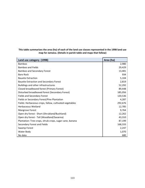
This table summarizes the area (ha) <strong>of</strong> each <strong>of</strong> the land use classes represented in the 1998 land usemap for <strong>Jamaica</strong>. (Details in parish table and maps that follow)Land use category (1998)Area (ha)Bamboo 2,980Bamboo and Fields 29,429Bamboo and Secondary Forest 13,481Bare Rock 934Bauxite Extraction 5,104Bauxite Extraction and Secondary Forest 2,819Buildings and other infrastructures 52,292Closed broadleaved forest (Primary Forest) 89,448Disturbed broadleaved forest (Secondary Forest) 185,056Fields and Secondary Forest 120,536Fields or Secondary Forest/Pine Plantation 4,287Fields: Herbaceous crops, fallow, cultivated vegetables 292,676Herbaceous Wetland 12,785Mangrove Forest 9,764Open dry forest - Short (Shrubland/Bushland) 12,262Open dry forest - Tall (Woodland/Savanna) 43,310Plantation: Tree crops, shrub crops, sugar cane, banana 87,199Secondary Forest and Fields 168,333Swamp Forest 2,247Water Body 1,070No data 680113