- Page 2:
Integrated Management of Arthropod
- Page 6:
Integrated Management of Arthropod
- Page 10:
PREFACE This is the last volume of
- Page 16:
viii CONTENTS 2.3.3. Chemical Contr
- Page 20:
x CONTENTS 3.4. Wildlife Benefits .
- Page 24:
xii CONTENTS 10 Control of Urticati
- Page 30:
CONTRIBUTORS Mohamed S. T. Abbas Pl
- Page 34:
OBITUARY NOTICE Prof. K. G. Mukerji
- Page 40:
Section 1 IPM IN CITRUS GROVES
- Page 44:
4 J.A. JACAS ET AL. decumana L.], b
- Page 48:
6 J.A. JACAS ET AL. tree volume. A
- Page 52:
8 J.A. JACAS ET AL. Table 2 continu
- Page 56:
10 J.A. JACAS ET AL. Table 2 contin
- Page 60:
12 J.A. JACAS ET AL. Table 2 contin
- Page 64:
14 J.A. JACAS ET AL. Table 4. Insec
- Page 68:
16 J.A. JACAS ET AL.
- Page 72:
18 J.A. JACAS ET AL.
- Page 76:
20 J.A. JACAS ET AL.
- Page 80:
22 J.A. JACAS ET AL. Table 6 contin
- Page 84:
24 J.A. JACAS ET AL. Table 7 contin
- Page 88:
26 J.A. JACAS ET AL. Table 8 contin
- Page 92:
2 MAIN ARTHROPOD PESTS OF CITRUS CU
- Page 96:
IPM OF CITRUS PESTS IN GREECE 31 Ta
- Page 100:
IPM OF CITRUS PESTS IN GREECE 33 ex
- Page 104:
IPM OF CITRUS PESTS IN GREECE 35 A
- Page 108:
IPM OF CITRUS PESTS IN GREECE 37 2.
- Page 112:
IPM OF CITRUS PESTS IN GREECE 39 re
- Page 116:
IPM OF CITRUS PESTS IN GREECE 41 mi
- Page 120:
IPM OF CITRUS PESTS IN GREECE 43 in
- Page 124:
IPM OF CITRUS PESTS IN GREECE 45 To
- Page 128:
IPM OF CITRUS PESTS IN GREECE 47 ca
- Page 132:
IPM OF CITRUS PESTS IN GREECE 49 In
- Page 136:
IPM OF CITRUS PESTS IN GREECE 51 oc
- Page 140:
IPM OF CITRUS PESTS IN GREECE 53 Re
- Page 144:
IPM OF CITRUS PESTS IN GREECE 55 Ka
- Page 148:
IPM OF CITRUS PESTS IN GREECE 57 Ne
- Page 152:
IPM OF CITRUS PESTS IN GREECE 59 (p
- Page 156:
62 J.A. JACAS & A. URBANEJA insuffi
- Page 160:
64 J.A. JACAS & A. URBANEJA 2. THE
- Page 164:
66 J.A. JACAS & A. URBANEJA Since t
- Page 168:
68 J.A. JACAS & A. URBANEJA because
- Page 172:
70 J.A. JACAS & A. URBANEJA showed
- Page 176:
72 J.A. JACAS & A. URBANEJA Lentere
- Page 180:
74 L. ZAPPALÀ etc.) that modified
- Page 184:
76 L. ZAPPALÀ Aonidiella aurantii
- Page 188:
78 L. ZAPPALÀ Although numerous na
- Page 192:
80 L. ZAPPALÀ depending on the mar
- Page 196:
82 L. ZAPPALÀ encyrtid A. citricol
- Page 200:
84 L. ZAPPALÀ In Italy C. phyllocn
- Page 204:
86 L. ZAPPALÀ Vivas, 1995; Argov,
- Page 208:
88 L. ZAPPALÀ the activity of the
- Page 212:
90 L. ZAPPALÀ yellowish-white, sle
- Page 216:
92 L. ZAPPALÀ Australia. Effective
- Page 220:
94 L. ZAPPALÀ (Hymenoptera: Apheli
- Page 224:
96 L. ZAPPALÀ Franco, J. C., Fortu
- Page 228:
98 L. ZAPPALÀ Mineo, G., & Mineo,
- Page 232:
100 L. ZAPPALÀ Zappalà, L., & Sis
- Page 236:
102 R. CAMPOS-HERRERA ET AL. chemic
- Page 240:
104 R. CAMPOS-HERRERA ET AL. 2. IPM
- Page 244:
106 R. CAMPOS-HERRERA ET AL. Hetero
- Page 248:
108 R. CAMPOS-HERRERA ET AL. indire
- Page 252:
110 R. CAMPOS-HERRERA ET AL. highes
- Page 256:
112 R. CAMPOS-HERRERA ET AL. infect
- Page 260:
114 R. CAMPOS-HERRERA ET AL. (1997)
- Page 264:
116 R. CAMPOS-HERRERA ET AL. endopa
- Page 268:
118 R. CAMPOS-HERRERA ET AL. presen
- Page 272:
120 R. CAMPOS-HERRERA ET AL. they p
- Page 276:
122 R. CAMPOS-HERRERA ET AL.
- Page 280:
124 R. CAMPOS-HERRERA ET AL. Atkins
- Page 284:
126 R. CAMPOS-HERRERA ET AL. Grewal
- Page 288:
128 R. CAMPOS-HERRERA ET AL. McCoy,
- Page 292:
130 R. CAMPOS-HERRERA ET AL. Wolcot
- Page 296:
6 INTEGRATION OF INSECT AND MITE MA
- Page 300:
IPM IN PECAN PRODUCTION 135 Pecan n
- Page 304:
IPM IN PECAN PRODUCTION 137 Weed co
- Page 308:
IPM IN PECAN PRODUCTION 139 hemipte
- Page 312:
IPM IN PECAN PRODUCTION 141 by Fusi
- Page 316:
IPM IN PECAN PRODUCTION 143 1989).
- Page 320: IPM IN PECAN PRODUCTION 145 orchard
- Page 324: IPM IN PECAN PRODUCTION 147 tree ro
- Page 328: IPM IN PECAN PRODUCTION 149 3.3. So
- Page 332: IPM IN PECAN PRODUCTION 151 climati
- Page 336: IPM IN PECAN PRODUCTION 153 Orchard
- Page 340: IPM IN PECAN PRODUCTION 155 populat
- Page 344: IPM IN PECAN PRODUCTION 157 Ark, P.
- Page 348: IPM IN PECAN PRODUCTION 159 Harris,
- Page 352: IPM IN PECAN PRODUCTION 161 Smith,
- Page 356: 7 LOCUST HABITAT MONITORING AND RIS
- Page 360: LOCUST REMOTE SENSING AND GIS 165 I
- Page 364: LOCUST REMOTE SENSING AND GIS 167 R
- Page 368: LOCUST REMOTE SENSING AND GIS 169 2
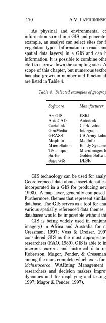
- Page 374: 172 A.V. LATCHININSKY & R. SIVANPIL
- Page 378: 174 A.V. LATCHININSKY & R. SIVANPIL
- Page 382: 176 A.V. LATCHININSKY & R. SIVANPIL
- Page 386: 178 A.V. LATCHININSKY & R. SIVANPIL
- Page 390: 180 A.V. LATCHININSKY & R. SIVANPIL
- Page 394: 182 A.V. LATCHININSKY & R. SIVANPIL
- Page 398: 184 A.V. LATCHININSKY & R. SIVANPIL
- Page 402: 186 A.V. LATCHININSKY & R. SIVANPIL
- Page 406: 188 A.V. LATCHININSKY & R. SIVANPIL
- Page 410: 190 FARHA-REHMAN ET AL. and composi
- Page 414: 192 FARHA-REHMAN ET AL. they are by
- Page 418: 194 FARHA-REHMAN ET AL. plant defen
- Page 422:
196 FARHA-REHMAN ET AL. tobacco pla
- Page 426:
198 FARHA-REHMAN ET AL. Simonetti,
- Page 430:
200 FARHA-REHMAN ET AL. pathway for
- Page 434:
202 FARHA-REHMAN ET AL. Thaler, Far
- Page 438:
204 FARHA-REHMAN ET AL. whereas on
- Page 442:
206 FARHA-REHMAN ET AL. Dicke, M.,
- Page 446:
208 FARHA-REHMAN ET AL. Van Poecke,
- Page 450:
210 M.S.T. ABBAS The high rate of s
- Page 454:
212 M.S.T. ABBAS rhinoceros but it
- Page 458:
214 M.S.T. ABBAS 3.2.3. Locomotion
- Page 462:
216 M.S.T. ABBAS was found to be pa
- Page 466:
218 M.S.T. ABBAS sealed with moiste
- Page 470:
220 M.S.T. ABBAS (Anonymous, 2001).
- Page 474:
222 M.S.T. ABBAS marked weevils wer
- Page 478:
224 M.S.T. ABBAS from that of males
- Page 482:
226 M.S.T. ABBAS those 3 isolates,
- Page 486:
228 M.S.T. ABBAS and wire screen. T
- Page 490:
230 M.S.T. ABBAS while H. bacteriop
- Page 494:
232 M.S.T. ABBAS Georgis, R. (1990)
- Page 498:
10 CONTROL OF URTICATING LEPIDOPTER
- Page 502:
AERIAL BT TREATMENTS 237 The main s
- Page 506:
AERIAL BT TREATMENTS 239 skin injec
- Page 510:
AERIAL BT TREATMENTS 241 Africa, or
- Page 514:
AERIAL BT TREATMENTS 243 Further la
- Page 518:
AERIAL BT TREATMENTS 245 Martin, J.
- Page 522:
Section 3 MITES BIOLOGICAL CONTROL
- Page 526:
250 L.P.S. VAN DER GEEST reproducti
- Page 530:
252 L.P.S. VAN DER GEEST midgut of
- Page 534:
254 L.P.S. VAN DER GEEST glands (On
- Page 538:
256 L.P.S. VAN DER GEEST related to
- Page 542:
258 L.P.S. VAN DER GEEST obligate i
- Page 546:
260 L.P.S. VAN DER GEEST Eotetranyc
- Page 550:
262 L.P.S. VAN DER GEEST number, st
- Page 554:
264 L.P.S. VAN DER GEEST The presen
- Page 558:
266 L.P.S. VAN DER GEEST Table 2 Co
- Page 562:
268 L.P.S. VAN DER GEEST twospotted
- Page 566:
270 L.P.S. VAN DER GEEST that the f
- Page 570:
272 L.P.S. VAN DER GEEST the surviv
- Page 574:
274 L.P.S. VAN DER GEEST Table 3. H
- Page 578:
276 L.P.S. VAN DER GEEST Table 3 Co
- Page 582:
278 L.P.S. VAN DER GEEST death of t
- Page 586:
280 L.P.S. VAN DER GEEST Several at
- Page 590:
282 L.P.S. VAN DER GEEST Figure 9.
- Page 594:
284 L.P.S. VAN DER GEEST of whitefl
- Page 598:
286 L.P.S. VAN DER GEEST fusion of
- Page 602:
288 L.P.S. VAN DER GEEST Table 4 Co
- Page 606:
290 L.P.S. VAN DER GEEST The phylum
- Page 610:
292 L.P.S. VAN DER GEEST 75% after
- Page 614:
294 L.P.S. VAN DER GEEST life span,
- Page 618:
296 L.P.S. VAN DER GEEST identifica
- Page 622:
298 L.P.S. VAN DER GEEST From the o
- Page 626:
300 L.P.S. VAN DER GEEST measures a
- Page 630:
302 L.P.S. VAN DER GEEST Chen, Y.,
- Page 634:
304 L.P.S. VAN DER GEEST James, D.
- Page 638:
306 L.P.S. VAN DER GEEST Oduor, G.
- Page 642:
308 L.P.S. VAN DER GEEST Speare, A.
- Page 646:
12 IPM STRATEGIES THROUGH SPECIALIS
- Page 650:
PREDATORY MITES IN IPM 313 Among na
- Page 654:
PREDATORY MITES IN IPM 315 antagoni
- Page 658:
PREDATORY MITES IN IPM 317 of sex a
- Page 662:
PREDATORY MITES IN IPM 319 Table 2
- Page 666:
PREDATORY MITES IN IPM 321 effect w
- Page 670:
PREDATORY MITES IN IPM 323 Castagno
- Page 674:
PREDATORY MITES IN IPM 325 Schausbe
- Page 678:
328 INDEX 237, 238, 241, 268, 269,
- Page 682:
330 INDEX Asaphes vulgaris, 46 Asap
- Page 686:
332 INDEX Btk spore, 243 Btk, 240-2
- Page 690:
334 INDEX Citrus aurantifolia, 3 Ci
- Page 694:
336 INDEX 254, 255, 267-269, 292, 2
- Page 698:
338 INDEX Dodine, 141, 142 Dorsal d
- Page 702:
340 INDEX Eulophidae, 20, 38, 43, 4
- Page 706:
342 INDEX 216, 249, 250, 260, 261,
- Page 710:
344 INDEX Hibernation, 47 Hickory s
- Page 714:
346 INDEX Iphiseius (Amblyseius) de
- Page 718:
348 INDEX Louisiana, 82 Lufenuron,
- Page 722:
350 INDEX Moisture, 146-148, 150, 1
- Page 726:
352 INDEX Nymphal distribution, 164
- Page 730:
354 INDEX Pecan trees, 134, 136, 14
- Page 734:
356 INDEX Pnigalio agraules, 85 Pni
- Page 738:
358 INDEX Regression model, 271 Reg
- Page 742:
360 INDEX Sethoxydim, 137, 144, 152
- Page 746:
362 INDEX Sunlight, 39, 90, 167, 25
- Page 750:
364 INDEX Trichlorfon, 21, 22, 24,
- Page 754:
366 INDEX Winter, 32, 51, 237, 241