Hydrocarbon Vision 2030 (ஹைட்ரோகார்பன் தொலைநோக்கு ஆவணம் 2030)

Create successful ePaper yourself
Turn your PDF publications into a flip-book with our unique Google optimized e-Paper software.
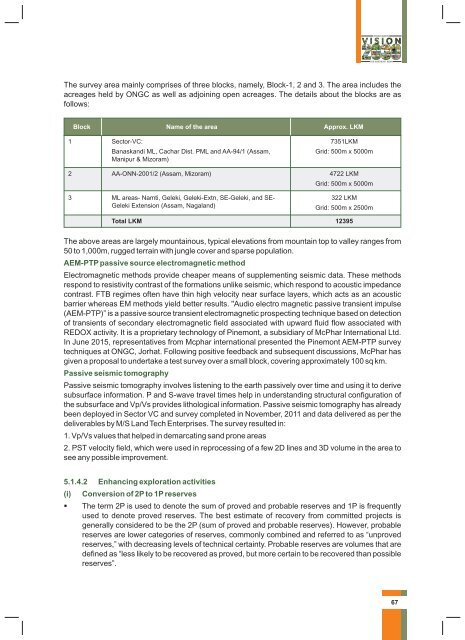
The survey area mainly comprises of three blocks, namely, Block-1, 2 and 3. The area includes the<br />
acreages held by ONGC as well as adjoining open acreages. The details about the blocks are as<br />
follows:<br />
Block<br />
Name of the area<br />
Approx. LKM<br />
1 Sector-VC:<br />
Banaskandi ML, Cachar Dist. PML and AA-94/1 (Assam,<br />
Manipur & Mizoram)<br />
7351LKM<br />
Grid: 500m x 5000m<br />
2 AA-ONN-2001/2 (Assam, Mizoram) 4722 LKM<br />
Grid: 500m x 5000m<br />
3 ML areas- Namti, Geleki, Geleki-Extn, SE-Geleki, and SE-<br />
Geleki Extension (Assam, Nagaland)<br />
322 LKM<br />
Grid: 500m x 2500m<br />
Total LKM 12395<br />
The above areas are largely mountainous, typical elevations from mountain top to valley ranges from<br />
50 to 1,000m, rugged terrain with jungle cover and sparse population.<br />
AEM-PTP passive source electromagnetic method<br />
Electromagnetic methods provide cheaper means of supplementing seismic data. These methods<br />
respond to resistivity contrast of the formations unlike seismic, which respond to acoustic impedance<br />
contrast. FTB regimes often have thin high velocity near surface layers, which acts as an acoustic<br />
barrier whereas EM methods yield better results. "Audio electro magnetic passive transient impulse<br />
(AEM-PTP)” is a passive source transient electromagnetic prospecting technique based on detection<br />
of transients of secondary electromagnetic field associated with upward fluid flow associated with<br />
REDOX activity. It is a proprietary technology of Pinemont, a subsidiary of McPhar International Ltd.<br />
In June 2015, representatives from Mcphar international presented the Pinemont AEM-PTP survey<br />
techniques at ONGC, Jorhat. Following positive feedback and subsequent discussions, McPhar has<br />
given a proposal to undertake a test survey over a small block, covering approximately 100 sq km.<br />
Passive seismic tomography<br />
Passive seismic tomography involves listening to the earth passively over time and using it to derive<br />
subsurface information. P and S-wave travel times help in understanding structural configuration of<br />
the subsurface and Vp/Vs provides lithological information. Passive seismic tomography has already<br />
been deployed in Sector VC and survey completed in November, 2011 and data delivered as per the<br />
deliverables by M/S Land Tech Enterprises. The survey resulted in:<br />
1. Vp/Vs values that helped in demarcating sand prone areas<br />
2. PST velocity field, which were used in reprocessing of a few 2D lines and 3D volume in the area to<br />
see any possible improvement.<br />
5.1.4.2 Enhancing exploration activities<br />
(i)<br />
Conversion of 2P to 1P reserves<br />
The term 2P is used to denote the sum of proved and probable reserves and 1P is frequently<br />
used to denote proved reserves. The best estimate of recovery from committed projects is<br />
generally considered to be the 2P (sum of proved and probable reserves). However, probable<br />
reserves are lower categories of reserves, commonly combined and referred to as “unproved<br />
reserves,” with decreasing levels of technical certainty. Probable reserves are volumes that are<br />
defined as “less likely to be recovered as proved, but more certain to be recovered than possible<br />
reserves”.<br />
67