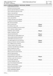
C:\ARQUIVO DE TRABALHO 2013\EDI - Unama
C:\ARQUIVO DE TRABALHO 2013\EDI - Unama
C:\ARQUIVO DE TRABALHO 2013\EDI - Unama

You also want an ePaper? Increase the reach of your titles
YUMPU automatically turns print PDFs into web optimized ePapers that Google loves.
85<br />
ESTUDO DA DINÂMICA POPULACIONAL NO PERÍODO <strong>DE</strong> 1970 – 2000:<br />
UMA ANÁLISE DO CENTRÓI<strong>DE</strong> E DA DISPERSÃO<br />
DA POPULAÇÃO NO ESTADO DO PARÁ<br />
José Ferreira da Rocha *<br />
Sérgio Castro Gomes **<br />
Magno Roberto Alves Macedo ***<br />
Eugênia Rosa Cabral ****<br />
RESUMO<br />
O presente trabalho apresenta dois objetivos principais que se correlacionam. Um<br />
interessado em analisar a dinâmica populacional no Estado do Pará nas décadas de 70,<br />
80 e 90, levando em consideração o padrão espacial da distribuição populacional. E<br />
outro de identificar a formação de aglomerados populacionais (clusters) no estado. Para<br />
analisar a distribuição espacial da população do estado foi calculado o centro médio,a<br />
distância padrão, a elipse do desvio padrão ponderadas pela população dos municípios.<br />
Para avaliar a formação de clusters de municípios, em relação ao tamanho da população<br />
residente foi encontrada a autocorrelação espacial local (LISA). Os resultados apontam<br />
evidências de que a população do estado se distribuiu espacialmente no sentido<br />
Nordeste/Sudoeste, no período de 1970-2000.<br />
Palavras-chave: Centro médio. Desvio padrão. Aglomerados. Centróide.<br />
A STUDY OF THE POPULATIONAL DYNAMIC BETWEEN 1970 AND 2000:<br />
A CENTROID AND DISPERSION POPULATION ANALYSIS IN THE PARÁ STATE<br />
ABSTRACT<br />
This paper presents two main objectives that correlate. One interested in analyzing<br />
population dynamics in Para State in the ’70s, ’80s and ’90s, taking into account the<br />
spatial pattern of population distribution. And another to identify the clustering of<br />
populations (clusters) in the state. To analyze the spatial distribution of the state<br />
population was calculated by the center median, the standard distance, the ellipse of<br />
*<br />
Instituto de Desenvolvimento Econômico, Social e Ambiental do Pará – I<strong>DE</strong>SP. Av. Municipalidade, 1461 – Umarizal<br />
– CEP: 66050-350 – Belém-PA. josef.rocha@idesp.pa.gov.br<br />
**<br />
Instituto de Desenvolvimento Econômico, Social e Ambiental do Pará – I<strong>DE</strong>SP. Av. Municipalidade, 1461 – Umarizal<br />
– CEP: 66050-350 – Belém-PA. Universidade da Amazônia – UNAMA. Avenida Alcindo Cacela, 287 – Umarizal<br />
– CEP: 66060-902 - Belém-PA. sergio.gomes@idesp.pa.gov.br<br />
***<br />
Instituto de Desenvolvimento Econômico, Social e Ambiental do Pará – I<strong>DE</strong>SP. Av. Municipalidade, 1461 – Umarizal<br />
– CEP: 66050-350 – Belém-PA. magno.macedo@idesp.pa.gov.br<br />
****<br />
Universidade da Amazônia – UNAMA. Av. Alcindo Cacela, 287 – Umarizal – CEP: 66060-902 – Belém – PA.<br />
eugeniacabral@unama.br<br />
Traços, Belém, v.12, n. 26, p. 85-99, dez. 2010