Rural Walks in Flintshire (pdf) - Flintshire County Council
Rural Walks in Flintshire (pdf) - Flintshire County Council
Rural Walks in Flintshire (pdf) - Flintshire County Council
- No tags were found...

You also want an ePaper? Increase the reach of your titles
YUMPU automatically turns print PDFs into web optimized ePapers that Google loves.
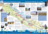
16HalkynMounta<strong>in</strong>Open common, <strong>in</strong>dustrial heritageand viewsHalkyn Mounta<strong>in</strong> is an Urban Common which meansyou can walk freely across it. Ten M<strong>in</strong>ute walks can bedone easily <strong>in</strong> the areas marked, or choose to walkfurther. However please take great care near old m<strong>in</strong>ework<strong>in</strong>gs as the Common is covered with vertical m<strong>in</strong>eshafts <strong>in</strong> various stages of repair. Please report any reopenedshafts to the Grosvenor Estate Office:Tel: 01244 684400Park<strong>in</strong>g at Rhosesmor Village Hall, <strong>in</strong> layby at Berth Ddu,or at one of the pubs with the landlord's permission.Tir Com<strong>in</strong> agored, treftadaethddiwydiannol a golygfeydd.Com<strong>in</strong> Trefol yw Mynydd Helyga<strong>in</strong>. Mae nifer o deithiaucerdded 10 munud wedi’u marcio, ond gallwch ddewiscerdded ymhellach. Mae hyn yn golygu y gallwchgerdded yn rhydd arno. Gofynnir ichi fod yn ofalus iawnyn ymyl hen byllau gan fod y Com<strong>in</strong> yn frith o siafftiau,bob un mewn cyflwr gwahanol o ran eu trwsio. Osgwelwch unrhyw siafftiau sy wedi ailagor gofynnir ichi roigwybod i Swyddfa Stad Grosvenor:Ffôn: 01244 684400.Ceir lleoedd parcio yn Neuadd y Pentref, Rhosesmor,yn y gilfan ym Mherth Ddu neu ym maes parcio uno'r tafarnau ar ôl cael caniatâd y tafarnwr.A broad <strong>in</strong>dication of the OpenAccess areas are shown on thismap. Private properties andwork<strong>in</strong>g quarries are not <strong>in</strong>cludedunder the Open Access legislation.For full details of Halkyn or anyother Open Access area refer towww.ccw.gov.ukMae'r map hwn yn dangos yn frasyr ardaloedd Mynediad Agored.Nid yw eiddo preifat a chwarelisy'n gweithio yn cael eu cynnwyso dan y ddeddfwriaeth MynediadAgored. I gael gwybodaethlawnach am Helyga<strong>in</strong> ac unrhywardaloedd Mynediad Agorederaill, ewch i www.ccw.gov.uk52View from trig po<strong>in</strong>tGolygfa o’r pwynt trigwww.borderlands.co.ukExplore Fl<strong>in</strong>sthire’s castles and monumentsFeatures of <strong>in</strong>terest1. Moel y Gaer is the highest po<strong>in</strong>t on thecommon with panoramic views from itssummit. The earth banks and ditchesencircl<strong>in</strong>g the summit are the rema<strong>in</strong>s ofan Iron Age hillfort. Rema<strong>in</strong>s of circularwooden huts and rectangular build<strong>in</strong>gs, thatmay have been granaries, have also beenfound. The hilltop was utilised aga<strong>in</strong> dur<strong>in</strong>gthe Napoleonic wars when a firebeacon wasbuilt to warn of French <strong>in</strong>vasion.The mounta<strong>in</strong> is dotted with the rema<strong>in</strong>s ofsmall early quarries and limekilns wherecrushed limestone was burned to producelime for build<strong>in</strong>g mortar and fertiliser.Waen Brodlas2. S<strong>in</strong>gle limekiln at Wern y Gaer3. Old quarry and double kiln near Rhes-y-cae4. The large kilns at Waen Brodlas produced