Rural Walks in Flintshire (pdf) - Flintshire County Council
Rural Walks in Flintshire (pdf) - Flintshire County Council
Rural Walks in Flintshire (pdf) - Flintshire County Council
- No tags were found...

You also want an ePaper? Increase the reach of your titles
YUMPU automatically turns print PDFs into web optimized ePapers that Google loves.
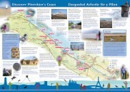
20Loggerheads– Moel FamauMounta<strong>in</strong> and forest withpanoramic viewsDistance: 9.8 km / 6.1 milesTime: 4.5 hrsPark<strong>in</strong>g and start: Loggerheads Country Park(SJ198626)Grade: Strenuous (one steep ascent), many stiles, can beboggy <strong>in</strong> placesFacilities: Countryside Centre, café and toilets atLoggerheads CP and pub oppositeLivestock: Sheep, cattle, horsesMynydd a choedwig gydagolygfeydd panoramigPellter: 9.8 km / 6.1 milltirAmser: 4.5 awrParcio a man cychwyn: Parc Gwledig Loggerheads cyf(SJ198626)Graddfa: Egniol (un ddr<strong>in</strong>gfa serth), sawl camfa, gall fodyn gorslyd mewn mannauCyfleusterau: Y Ganolfan Cefn Gwlad, caffi a thoiledauym Maes Parcio a'r dafarn gyferbynDa byw: Defaid, gwartheg, ceffylau60www.borderlands.co.ukWhere to eat great food <strong>in</strong> Fl<strong>in</strong>tshireParaglid<strong>in</strong>g over theClwydian RangeParagleidio drosFryniau ClwydSGKstile/ camfagate/ giâtkiss<strong>in</strong>g gate/ giât mochynpub/ tafarnpark<strong>in</strong>g/ maes parcioright of way/ hawl tramwyoroute/ y llwybrMoelFamau S3 554mJubilee TowerTwr ˆ JiwibiliThe WalkGGSGSS GGG GSFfrithMounta<strong>in</strong>Mynydd Ffrith378mBrithdir Mawr2 S S S1. From car park head towards road entrance,branch<strong>in</strong>g R as <strong>in</strong>dicated to jo<strong>in</strong> lane. Turn Ruphill, then cont<strong>in</strong>ue for 800m to T-Junction,turn R (signed Cilca<strong>in</strong>). After 25m turn L thro'metal gate (opposite f<strong>in</strong>gerpost signed MoelFamau). Cont<strong>in</strong>ue ahead for 200m then thro'another gate (ignore footpath on R). Cont<strong>in</strong>uealong sunken lane, cross<strong>in</strong>g another stile bygate, and cont<strong>in</strong>u<strong>in</strong>g ahead, (ignore path on Rof gate and path on L 20m later). After 100mpass thro' open gateway and cont<strong>in</strong>ue alongRH field boundary for 225m. Then turn L uptrack by f<strong>in</strong>gerpost. Turn R over stile beforegate. Cross field corner to stile. Over stile andturn R along forest edge.2. After 75m cross over stile by f<strong>in</strong>gerpost.Bear diagonally R to second f<strong>in</strong>ger post.Cross stream via sleeper bridge and cont<strong>in</strong>uealong field boundary for 150m before turn<strong>in</strong>gdiagonally L to head up field. Notice BrithdirMawr on R. Just before field boundary turn Rand ford stream. Cross gate/stile and cont<strong>in</strong>ueahead towards gate (ignore path on RHS after100m). Turn L before gate over stile <strong>in</strong>toforest. Walk steeply uphill, cross<strong>in</strong>g cycleroute after 400m and cont<strong>in</strong>u<strong>in</strong>g aheadfor further 500m. Turn L at marker postwhere path descends briefly, then ascendsteeply aga<strong>in</strong> for 400m to stile belowMoel Famau summit.3. To descend turn R along clear path for700m, with tree l<strong>in</strong>e on RHS. At pathcrossroads turn R along bridleway. Passthrough small gate after 200m and cont<strong>in</strong>uedownhill with old stonewall on RHS. After600m ignore small gate on RHS and cont<strong>in</strong>ueahead, signed Loggerheads, for 500m to gateand stile. Cross stile/gate and cont<strong>in</strong>ue pastf<strong>in</strong>gerpost, signed Loggerheads, where pathS4S S S SBryn y CastellGSGKG005KAlynKennelsParc GwledigLoggerheadsCountry ParkA4940.5 mile/ militir1 km/ cilomedrCaffi Florence1We ThreeLoggerheadsjo<strong>in</strong>s from L (rema<strong>in</strong>s of World War IIaeroplane decoy centre on LHS). Go thro'gate ahead and cont<strong>in</strong>ue along path, thro'two more gates. At junction turn L ontolane, signed Loggerheads, and walk downhillto road.4. Cross road and over stile opposite, besidesign to Loggerheads, onto concealed footpath.Follow path past house on R. Over stile andacross field to another stile. Cross drive andcont<strong>in</strong>ue thro' gate along waymarked pathahead. Over 2 more stiles and cross footbridgeover River Alyn. Thro' squeeze stile and, wherepath forks, take waymarked path R uphill.At top of hill turn R onto Leete path. At nextpath fork bear L on wider path to jo<strong>in</strong> lane.5. Turn R on lane and cont<strong>in</strong>ue ahead pass<strong>in</strong>gAlyn Kennels on R. Thro' KG beh<strong>in</strong>d kennelsand follow path back <strong>in</strong>to LoggerheadsCountry Park. Ignore footbridge on R andcont<strong>in</strong>ue along path with river on R. Crossover stone bridge and walk back toCountryside Centre and car park.Rema<strong>in</strong>s of a WWII aeroplane decoy centreOlion canolfan denu awyrennau o'r Ail Ryfel Byd