Rural Walks in Flintshire (pdf) - Flintshire County Council
Rural Walks in Flintshire (pdf) - Flintshire County Council
Rural Walks in Flintshire (pdf) - Flintshire County Council
- No tags were found...

You also want an ePaper? Increase the reach of your titles
YUMPU automatically turns print PDFs into web optimized ePapers that Google loves.
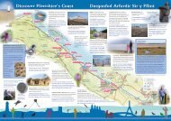
18Hendre-BodfariA l<strong>in</strong>ear walk along a sunken laneand the Clwydian RidgeDistance: 11 km / 6.8 milesTime: 4.5 – 5 hrsPark<strong>in</strong>g and start: The Royal Oak, Hendre (SJ189676).This walk has been designed for use with the Mold-Denbigh bus service (no.14). Park<strong>in</strong>g is available at theRoyal Oak with the landlord’s permission (01352 741466).Facilities: Pub at Hendre and pub and shop <strong>in</strong> BodfariTen M<strong>in</strong>ute Walk: Two pleasant tracks bordered by woodsand farmland. Moel Arthur section has fantastic viewsGrade: StrenuousLivestock: Sheep on open moorlandTaith gerdded l<strong>in</strong>ellol ar hyd lonsuddedig a Chefnen Bryniau ClwydPellter: 11 km / 6.8 milltir Amser: 4.5 – 5 awrParcio a man cychwyn: Y Dderwen, Hendre(SJ189676). Lluniwyd y daith hon i'w defnyddio gyda'rgwasanaeth bysiau o'r Wyddgrug i Dd<strong>in</strong>bych (rhif.14).Gellir parcio ym maes parcio'r Dderwen, gyda chaniatâdy tafarnwr (01352 741466).Cyfleusterau: Tafarn yn yr Hendre a thafarn a siopym ModfariTaith gerdded 10 munud: Dau lwybr braf drwy’r coeda thir amaethyddol. Golygfeydd gwych o Foel ArthurGraddfa: Rhwng cymedrol ac egniolDa byw: Defaid ar y rhostir agored56Waymark<strong>in</strong>g / Arwyddion:www.borderlands.co.ukGreat places to stay <strong>in</strong> Fl<strong>in</strong>tshireˇPart / Mewn rhannauPenycloddiauThe Walk1. From the Royal Oak, go to bus stop andthen take side road on L. Turn R across front of“Oak Cottage”. Follow path thro' trees pass<strong>in</strong>gold quarry build<strong>in</strong>gs. Cont<strong>in</strong>ue on track (can bemuddy) along edge of wood, to sw<strong>in</strong>g L alongaccess track to Ty-isaf and follow to road.2. Cross road and go up by-way opposite.At house bear right and cont<strong>in</strong>ue for 550mto T-junction. Turn L and cont<strong>in</strong>ue, ignor<strong>in</strong>gfootpaths to R & L after 500m and L turnmarked “Bridlepath – motor vehiclesprohibited”. Cont<strong>in</strong>ue uphill to gate.3. Go thro' gate and turn R onto track. Followtrack across open country. Pass thro' gate after500m and cont<strong>in</strong>ue on track along forest edge,thro' double set of gates. Cont<strong>in</strong>ue for 75m tom<strong>in</strong>or road. Turn L and cont<strong>in</strong>ue along road tosmall car park on R below Moel Arthur.4. Turn R and follow path signed “LlangwyfanForest 1ml”. The route now follows Offa'sDyke Path (ODP), which has white acornmarkers. The path rises quickly but you arerewarded with f<strong>in</strong>e views. When path beg<strong>in</strong>sto level out look for slate marker, <strong>in</strong>dicat<strong>in</strong>gpath to Moel Arthur summit (an Iron Agehillfort). Cont<strong>in</strong>ue ahead cross<strong>in</strong>g 2 stilesdur<strong>in</strong>g descent. Cross next stile and bearR to m<strong>in</strong>or road. Turn R then, after 65m,turn L <strong>in</strong>to small car park.5. Go thro'gate <strong>in</strong> LH corner. At path junctionahead take R fork then, after 20m, branch Rby marker post, signed ODP. Follow ris<strong>in</strong>gpath thro' p<strong>in</strong>e trees to arrive at stile/gate.Cross stile and go diagonally L to reach summitof Penycloddiau, another Iron Age hillfort.Cont<strong>in</strong>ue along ridge, gradually descend<strong>in</strong>g.Cross stile and cont<strong>in</strong>ue for about 1km tometal gate with p<strong>in</strong>e trees on R.6. Cross stile/gate onto road. Cont<strong>in</strong>ue aheadfor 20m then turn L over stile/gate, signedODP. Take LH track to Bodfari descend<strong>in</strong>gslope. Cross stile/gate and cont<strong>in</strong>ue pastderelict farm build<strong>in</strong>gs to cross stile/gate. PassTy Newydd on R and farm drive on L shortlyafter. Cross small stream then bear L atf<strong>in</strong>gerpost along grassy terrace. Ignore path Lafter 300m. At path junction cont<strong>in</strong>ue aheadthen take L fork at f<strong>in</strong>ger post. Cross stile/gateand turn immediately R. Cont<strong>in</strong>ue across fieldsalong ODP, cross<strong>in</strong>g 4 stiles. Then cross stile byGrove House and turn R along drive to road.7. Turn L, signed Bodfari. At T-junction turn Rthen after 20m turn L by f<strong>in</strong>ger post. Cont<strong>in</strong>uedown tarmac lane for 200m then turn R thro'kiss<strong>in</strong>g gate. Cont<strong>in</strong>ue ahead and cross bridgeover River Wheeler. Cont<strong>in</strong>ue ahead thro' gateonto the busy A541. The bus stop oppositeprovides a return service to Mold or Hendre.