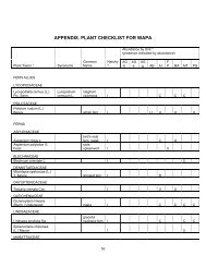
- Page 1 and 2:
COOPERATIVE NATIONAL PARK RESOURCES
- Page 3 and 4:
PREFACE TABLE OF CONTENTS Apple, Ru
- Page 5 and 6:
Gon, Samuel M., 111 ALTITUDINAL EFF
- Page 7 and 8:
Stemmermann, Lani HALEAKALA NATIONA
- Page 9 and 10:
ROOF RAT DEPREDATIONS ON HIBISCADEL
- Page 11 and 12:
Feeding upon seed pods Immature see
- Page 13 and 14:
NENE REINTRODUCTION PROGRAM AND RES
- Page 15 and 16:
R. C. L. Perkins (1903) also believ
- Page 17 and 18:
Although Nene in HAVO pens are expo
- Page 19 and 20:
irds have been forced to mate with
- Page 21 and 22:
TABLE 1. Individual results of 6nl
- Page 23 and 24:
TABLE 2. Combined results of NEnS b
- Page 25 and 26:
therefore be of interest to review
- Page 27 and 28:
wasp was found to parasitize the la
- Page 29 and 30:
In line with this thinking, immedia
- Page 31 and 32:
aIal 5 ." U) 0 a, U u C 0 4 w rlw r
- Page 33 and 34:
BIOLOGICAL CONTROL OF WILDLAND WEED
- Page 35 and 36:
15 species of introduced insects es
- Page 37 and 38:
HALEAKALA NATIONAL PARK CRATER DIST
- Page 39 and 40:
areas include the planthoppers (Del
- Page 41 and 42:
HAWAII IBP SYNTHESIS : 5. SHORT-TER
- Page 43 and 44:
We in the Forest Service are excite
- Page 45 and 46:
shrubby Dubautia and numerous hybri
- Page 47 and 48:
TABLE 1. Dubautia and Argyroxiphium
- Page 49 and 50:
SOME ASPECTS OF A SHELL DISEASE IN
- Page 51 and 52:
Induction of Lesions To induce lesi
- Page 53 and 54:
lesions. Or they may be part of the
- Page 55 and 56:
LITERATURE CITED Akin, D. E., and H
- Page 57 and 58:
TABLE 3. Isolation of chitinoclasti
- Page 59 and 60:
FOREST BIRD POPULATIONS ON O'AHU Ma
- Page 61 and 62:
LEK BEHAVIOR AND ECOLOGY OF TWO HOM
- Page 63 and 64:
either species) after an encounter
- Page 65 and 66:
HAWAII IBP SYNTHESIS : 3. THE KILAU
- Page 67 and 68:
RESULTS AND DISCUSSION Fifteen exot
- Page 69 and 70:
One exotic bird not found but previ
- Page 71 and 72:
TABLE 1. A list of the birds in the
- Page 73 and 74:
TABLE 2. Densities (birds/4O ha) of
- Page 75 and 76:
FIGURE 1. A map showing the locatio
- Page 77 and 78:
FIGURE 3. A map showinq native fore
- Page 79 and 80:
Several patterns in avian distribut
- Page 81 and 82:
LITERATURE CITED Eden, J. T. 1971.
- Page 83 and 84:
TABLE 1--Continued . Scientific Nam
- Page 85 and 86:
The objective of this paper is to a
- Page 87 and 88:
Selective field hybridizations yiel
- Page 89 and 90:
Corn, C. A. 1979. Variation in Hawa
- Page 91 and 92:
POLY MORPHA ---- NO SEED - SEED PRO
- Page 93 and 94:
THE RARE AND THREATENED PLANTS IN T
- Page 95 and 96:
open ideas for consideration and to
- Page 97 and 98:
Presence-absence trait analysis fur
- Page 99 and 100:
small clearings of soil-humus depos
- Page 101 and 102:
LITERATURE CITED Barrau, J. 1961. S
- Page 103 and 104:
WIDTH OF LARGEST WALL (cm) TOTAL AR
- Page 105 and 106:
ESTABLISHMENT OF SOME RECENT IMMIGR
- Page 107 and 108:
An egg parasite*, Trissolcus sp., w
- Page 109 and 110:
caterpillars were found on young nu
- Page 111 and 112:
'IRBLE 1. Sunnnq of sm recent imniq
- Page 113 and 114:
can be expected to provide will be
- Page 115 and 116:
Dombois 1977). Of course the trees
- Page 117 and 118:
We see from the two figures that in
- Page 119 and 120:
Ole HEALTHY, h FIGURE 1. Probabilit
- Page 121 and 122:
EVALUATION OF A NEW TECHNIQUE FOR H
- Page 123 and 124:
in the vial cap and was immersed in
- Page 125 and 126:
usually requiring only a few minute
- Page 127 and 128:
FACTORS CONTROLLING THE DISTRIBUTIO
- Page 129 and 130:
With respect to the distribution of
- Page 131 and 132:
native rain forest. However, the se
- Page 133 and 134:
mites are parasitic forms which hav
- Page 135 and 136:
LITERATURE CITED Atyeo, W. T., and
- Page 137 and 138:
TABLE 2. Feather mites recovered £
- Page 140 and 141:
Hirstionyssidae Rhinonyssidae (Rode
- Page 142 and 143:
STUDY SITE The ahupua'a of Manuka,
- Page 144 and 145:
DISCUSSION The trend of increasing
- Page 146 and 147:
litter habitats at lower and higher
- Page 148 and 149:
plant species diversity. The more d
- Page 150 and 151:
vegetational situation, and habitat
- Page 152 and 153:
TABLE 1. mmber of families encounte
- Page 154 and 155:
KEY: Nmhr of families colleded fran
- Page 157 and 158:
HALEAKALA NATIONAL PARK CRATER DIST
- Page 159 and 160:
Isopterygium Plagiothecium cavifoli
- Page 161 and 162:
TABLE 1. Phytogeographic relationsh
- Page 163 and 164:
In Hawai'i rain water percolates ra
- Page 165 and 166:
Most continental troglobites are co
- Page 167 and 168:
(5) Caves are fragile ecosystems an
- Page 169 and 170:
the current onslaught. It is true t
- Page 171 and 172:
Maciolek, J. A., and R. E. Brock. 1
- Page 173 and 174:
In the fallowing paper, a quick sum
- Page 175 and 176:
have been identified which include,
- Page 177 and 178:
LLTERATURE CITED Htmda, N., and J.
- Page 179 and 180:
TABLE 2. Cmpnents for the tree laye
- Page 181 and 182:
TABLE 4. Example of a vegetation ty
- Page 183 and 184:
ETGLTRE 2. Location of the U. S. Fi
- Page 185 and 186:
The sweet potato is unique in that
- Page 187 and 188:
tempting to suggest that the introd
- Page 189 and 190:
LITERATURE CITED Brand, D. D. 1971.
- Page 191 and 192:
DEDICATION ADDRESS FOR HAWAII FIELD
- Page 193 and 194:
I want to say that I strongly disag
- Page 195 and 196:
We will see how far these ideas get
- Page 197 and 198:
While the $28,000 would not even bu
- Page 199 and 200:
By no means, however, do I imply th
- Page 201 and 202:
Due primarily to lack of personnel
- Page 203 and 204:
National Park Service. 1969. Dark-r
- Page 205 and 206:
HAWAII IBP SYNTHESIS : 7. IMPACT OF
- Page 207 and 208:
Management Techniques The first clu
- Page 209 and 210:
!IWLE 1. Summary of production at 6
- Page 211 and 212:
PART A: Shipnan Strain Geese (14 Ge
- Page 213 and 214:
WLE 4. Gn5 restoration project reco
- Page 215 and 216:
HUMAN PERCEPTION OF THE HAWAIIAN EN
- Page 217 and 218:
public opinion concerning the issue
- Page 219 and 220:
(Question) Variables No Bsponse TAB
- Page 221 and 222:
(Question) Variables 10 11 12 13 14
- Page 223 and 224:
This is a survey to find out how th
- Page 225 and 226:
THE SEPTEMBER 1977 ERUPTION OF KILA
- Page 227:
General Conclusions 1. Zonal (or co
- Page 230 and 231:
- )RIGIN - TeC - TeL - TrP - 11.000
- Page 232 and 233:
A SOIL FUNGUS SET I B C ZONES SET2
- Page 234 and 235:
The high tree species diversity of
- Page 236 and 237:
It is probable that ecological gene
- Page 238 and 239:
THE ROLE OF THE HAWAIIAN TWO-LINED
- Page 240 and 241:
HABITAT UTILIZATION AND NICHE COMPO
- Page 242 and 243:
Hawaii Field Research Center. The p
- Page 244 and 245:
It is understandable that there is
- Page 246 and 247:
To accomplish the objectives of the
- Page 248 and 249:
FIGURE 1. Map of the island of Hawa
- Page 250 and 251:
METHODS Old mamane seed pods were c
- Page 252 and 253:
Seedling survival Seedling survival
- Page 254 and 255:
TABLE 1. Comparisons of percent see
- Page 256 and 257:
254 Figure 2--Cumulative number of
- Page 258 and 259:
COMMUNICATIONS TECHNIQUES AND THE S
- Page 260 and 261:
In a ten-minute paper like today's,
- Page 262 and 263:
ut are now growing in a normal upri
- Page 264 and 265:
Table 1--Grafting trials of Acacia
- Page 266:
Table 3--Treatments applied to Acac
- Page 269 and 270:
Table 5--Clonal variation in rootin
- Page 271 and 272:
with the major distribution being i
- Page 273 and 274:
as size classes (height and diamete
- Page 275 and 276:
there were more available microhabi
- Page 277 and 278:
CONCLUSIONS The Devastation Study A
- Page 279 and 280:
TABLE 1. Habitat 5. Structure and v
- Page 281 and 282:
VBLC 3. Witat 5. Wantitative charac
- Page 283 and 284:
HABITAT PROFILE - NOS. 1.2,4,5,6 OF
- Page 285 and 286:
HALEAKALA NATIONAL PARKCRATER DISTR
- Page 287 and 288:
LITERATURE CITED Bryan, W. A. 1915.
- Page 289 and 290:
climates experience alternating per
- Page 291 and 292: correlated with the amount and phys
- Page 293 and 294: HALEAKALA NATIONAL PARK CRATER DIST
- Page 295 and 296: LITERATURE CITED Degener, 0. 1930.
- Page 297 and 298: TABLE 2. Potentially aggressive wee
- Page 299 and 300: - Rubus rosaefolius Sn. 2 !l%e thim
- Page 301 and 302: Land availability is necessary to a
- Page 303 and 304: Conf irmatlon of existing informati
- Page 305 and 306: A NECROPSY PROCEDURE FOR SAMPLING D
- Page 307 and 308: Division, P. 0. Bos 243, Cockeysvil
- Page 309 and 310: Instructions RESULTS The following
- Page 311 and 312: I. External Analysis (Examine bird
- Page 313 and 314: PART I1 (1) Face, legs, or feet: le
- Page 315 and 316: (14) Feather, follicle, or skin par
- Page 317 and 318: Examine a wet smear of intestinal c
- Page 319 and 320: SUMMARY More work needs to be done
- Page 321 and 322: TABLE 1. Summary of diseases in avi
- Page 323 and 324: TABIE l--Continued '. Disease Patho
- Page 325 and 326: TABLE 1--Continued '. Disease Patho
- Page 327: ' Information not our own is £ran
- Page 330 and 331: the bare-root system have failed. K
- Page 332 and 333: Results of the efforts on the first
- Page 334 and 335: Areas for these vegetation communit
- Page 336 and 337: FIGURE 1. Courses of the topographi
- Page 339 and 340: 2500 mm ---+ MEAN ANNUAL PRECIPITAT
- Page 341: FOREST BIRD POPULATION VARIATION AS
- Page 345 and 346: PREHISTORIC HAWAIIAN BIRDS * Alan C
- Page 347 and 348: List of Participants (Continued) De
- Page 349 and 350: List of Participants (Continued) Ca