

Appendix 2 - Vegetation Communities and Regional Ecosystems
Appendix 2 - Vegetation Communities and Regional Ecosystems
Appendix 2 - Vegetation Communities and Regional Ecosystems

Create successful ePaper yourself
Turn your PDF publications into a flip-book with our unique Google optimized e-Paper software.
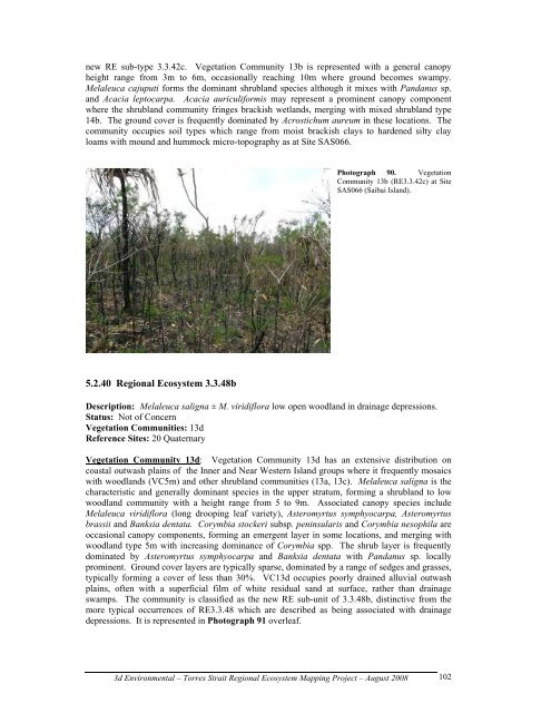
new RE sub-type 3.3.42c. <strong>Vegetation</strong> Community 13b is represented with a general canopy<br />
height range from 3m to 6m, occasionally reaching 10m where ground becomes swampy.<br />
Melaleuca cajuputi forms the dominant shrubl<strong>and</strong> species although it mixes with P<strong>and</strong>anus sp.<br />
<strong>and</strong> Acacia leptocarpa. Acacia auriculiformis may represent a prominent canopy component<br />
where the shrubl<strong>and</strong> community fringes brackish wetl<strong>and</strong>s, merging with mixed shrubl<strong>and</strong> type<br />
14b. The ground cover is frequently dominated by Acrostichum aureum in these locations. The<br />
community occupies soil types which range from moist brackish clays to hardened silty clay<br />
loams with mound <strong>and</strong> hummock micro-topography as at Site SAS066.<br />
5.2.40 <strong>Regional</strong> Ecosystem 3.3.48b<br />
Photograph 90. <strong>Vegetation</strong><br />
Community 13b (RE3.3.42c) at Site<br />
SAS066 (Saibai Isl<strong>and</strong>).<br />
Description: Melaleuca saligna ± M. viridiflora low open woodl<strong>and</strong> in drainage depressions.<br />
Status: Not of Concern<br />
<strong>Vegetation</strong> <strong>Communities</strong>: 13d<br />
Reference Sites: 20 Quaternary<br />
<strong>Vegetation</strong> Community 13d: <strong>Vegetation</strong> Community 13d has an extensive distribution on<br />
coastal outwash plains of the Inner <strong>and</strong> Near Western Isl<strong>and</strong> groups where it frequently mosaics<br />
with woodl<strong>and</strong>s (VC5m) <strong>and</strong> other shrubl<strong>and</strong> communities (13a, 13c). Melaleuca saligna is the<br />
characteristic <strong>and</strong> generally dominant species in the upper stratum, forming a shrubl<strong>and</strong> to low<br />
woodl<strong>and</strong> community with a height range from 5 to 9m. Associated canopy species include<br />
Melaleuca viridiflora (long drooping leaf variety), Asteromyrtus symphyocarpa, Asteromyrtus<br />
brassii <strong>and</strong> Banksia dentata. Corymbia stockeri subsp. peninsularis <strong>and</strong> Corymbia nesophila are<br />
occasional canopy components, forming an emergent layer in some locations, <strong>and</strong> merging with<br />
woodl<strong>and</strong> type 5m with increasing dominance of Corymbia spp. The shrub layer is frequently<br />
dominated by Asteromyrtus symphyocarpa <strong>and</strong> Banksia dentata with P<strong>and</strong>anus sp. locally<br />
prominent. Ground cover layers are typically sparse, dominated by a range of sedges <strong>and</strong> grasses,<br />
typically forming a cover of less than 30%. VC13d occupies poorly drained alluvial outwash<br />
plains, often with a superficial film of white residual s<strong>and</strong> at surface, rather than drainage<br />
swamps. The community is classified as the new RE sub-unit of 3.3.48b, distinctive from the<br />
more typical occurrences of RE3.3.48 which are described as being associated with drainage<br />
depressions. It is represented in Photograph 91 overleaf.<br />
3d Environmental – Torres Strait <strong>Regional</strong> Ecosystem Mapping Project – August 2008<br />
102