

Appendix 2 - Vegetation Communities and Regional Ecosystems
Appendix 2 - Vegetation Communities and Regional Ecosystems
Appendix 2 - Vegetation Communities and Regional Ecosystems

You also want an ePaper? Increase the reach of your titles
YUMPU automatically turns print PDFs into web optimized ePapers that Google loves.
5.2.30 <strong>Regional</strong> Ecosystem 3.3.10<br />
Description: Melaleuca argentea <strong>and</strong>/or M. fluviatilis ± M. leucadendra open forest. Fringes<br />
streams <strong>and</strong> creeks.<br />
Status: Not of Concern<br />
<strong>Vegetation</strong> <strong>Communities</strong>: 3b, 3g, 5h, 7f, 14o<br />
Reference Sites: 5 Quaternary<br />
<strong>Vegetation</strong> Community 7f: The dominant component of this RE is VC7f representing an open<br />
to tall open forest of Melaleuca leucadendra. It occurs commonly as a riparian fringe on major<br />
drainage features, extending to broader flood overflow plains in some locations. On riparian<br />
areas <strong>and</strong> associated overflow channels, Melaleuca leucadendra forms the canopy ranging in<br />
height from 15m in poorly developed communities on Warral Isl<strong>and</strong>, to greater than 30m on welldrained<br />
flood overflow channels on Muralug. <strong>Vegetation</strong> Community 7f is also represented by a<br />
woodl<strong>and</strong> variant extending away from the riparian margins across a silty flood plain (PW81).<br />
This Melaleuca leucadendra dominant community has a mixed sub-canopy layer of which<br />
Melaleuca saligna <strong>and</strong> Corypha utan are components. The occurrence of the latter species is a<br />
significant extension of range north from the Dulhunty River (Forster 1996) although the most<br />
northerly vouchered material at BRI is from near Aurukun (P. Forster pers. comm. March 2008).<br />
It also occurs in the Northern Territory. Similar communities on drainage swamps are<br />
represented as RE3.3.14b (VC7fs).<br />
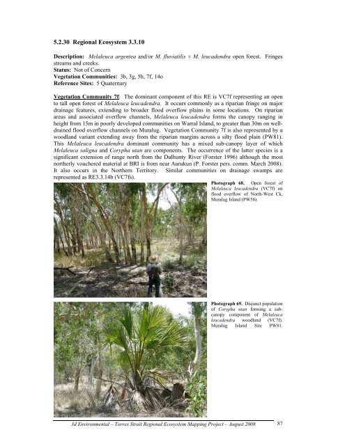
Photograph 68. Open forest of<br />
Melaleuca leucadendra (VC7f) on<br />
flood overflow of North-West Ck,<br />
Muralug Isl<strong>and</strong> (PW58).<br />
Photograph 69. Disjunct population<br />
of Corypha utan forming a subcanopy<br />
component of Melaleuca<br />
leucadendra woodl<strong>and</strong> (VC7f).<br />
Muralug Isl<strong>and</strong> Site PW81.<br />
3d Environmental – Torres Strait <strong>Regional</strong> Ecosystem Mapping Project – August 2008<br />
87