

Appendix 2 - Vegetation Communities and Regional Ecosystems
Appendix 2 - Vegetation Communities and Regional Ecosystems
Appendix 2 - Vegetation Communities and Regional Ecosystems

Create successful ePaper yourself
Turn your PDF publications into a flip-book with our unique Google optimized e-Paper software.
Plant taxonomy <strong>and</strong> distributional data have been considerably advanced through initiatives such<br />
as CYPLUS <strong>and</strong> various taxonomic treatments.<br />
Studies of past environments have also developed an increasing body of literature. Palynological<br />
studies (Rowe 2006, Parr 2003, Barham 1999) <strong>and</strong> archaeological <strong>and</strong> anthropological<br />
investigations (David et al. 2004, David <strong>and</strong> Badugal 2006, Barham <strong>and</strong> Harris 1987, Barham et<br />
al. 2004, Shnukal 2004, McNiven 2008) offer an important cultural context for biodiversity<br />
assessment <strong>and</strong> elucidate anthropogenic influences on isl<strong>and</strong> biodiversity over a period of human<br />
occupation in the region of between 8 000 <strong>and</strong> 6 000 years (Rowe 2006) with permanent isl<strong>and</strong><br />
occupation occurring between around 3 800–2 500 years (BP) (David <strong>and</strong> Badugal 2006).<br />
3.2 Image Base Compilation <strong>and</strong> Aerial Photograph Analysis<br />
The initial stage of desktop assessment involved a compilation of remotely sensed imagery<br />
suitable for vegetation mapping purposes. Aerial photography was the preferred information<br />
base, allowing stereoscopic assessment of vegetation <strong>and</strong> l<strong>and</strong>form patterns <strong>and</strong> giving greater<br />
confidence to assignment of l<strong>and</strong> zone <strong>and</strong> vegetation structure classification. Historical aerial<br />
photography also provided a means to assess the pre-clearing distribution of vegetation<br />
communities in a large number of cases. Satellite imagery was used as a secondary means of<br />
vegetation community assessment where suitable aerial photography was not available, <strong>and</strong> was<br />
used as a base for photo-registration during digital processing, as well as a means of st<strong>and</strong>ardising<br />
vegetation mapping scales. A summary of aerial photography used in this assessment is provided<br />
in Table 4 below. Assessment of photograph quality relates to a subjective appraisal of image<br />
clarity, site coverage, shadow <strong>and</strong> cloud cover.<br />
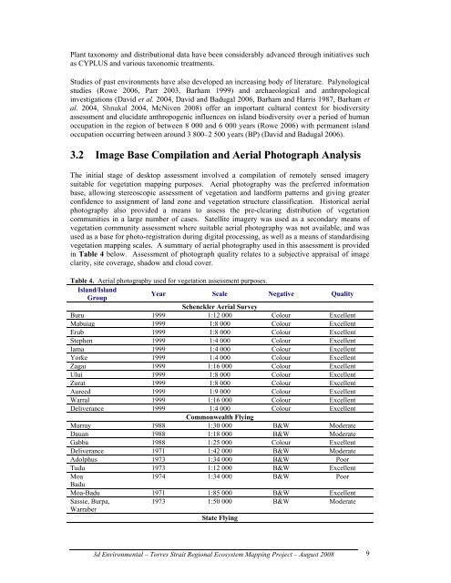
Table 4. Aerial photography used for vegetation assessment purposes.<br />
Isl<strong>and</strong>/Isl<strong>and</strong><br />
Group<br />
Year Scale<br />
Schenckler Aerial Survey<br />
Negative Quality<br />
Buru 1999 1:12 000 Colour Excellent<br />
Mabuiag 1999 1:8 000 Colour Excellent<br />
Erub 1999 1:8 000 Colour Excellent<br />
Stephen 1999 1:4 000 Colour Excellent<br />
Iama 1999 1:4 000 Colour Excellent<br />
Yorke 1999 1:4 000 Colour Excellent<br />
Zagai 1999 1:16 000 Colour Excellent<br />
Ului 1999 1:8 000 Colour Excellent<br />
Zurat 1999 1:8 000 Colour Excellent<br />
Aureed 1999 1:9 000 Colour Excellent<br />
Warral 1999 1:16 000 Colour Excellent<br />
Deliverance 1999 1:4 000<br />
Commonwealth Flying<br />
Colour Excellent<br />
Murray 1988 1:30 000 B&W Moderate<br />
Dauan 1988 1:18 000 B&W Moderate<br />
Gabba 1988 1:25 000 Colour Excellent<br />
Deliverance 1971 1:42 000 B&W Moderate<br />
Adolphus 1973 1:34 000 B&W Poor<br />
Tudu 1973 1:12 000 B&W Excellent<br />
Moa<br />
Badu<br />
1974 1:34 000 B&W Poor<br />
Moa-Badu 1971 1:85 000 B&W Excellent<br />
Sassie, Burpa,<br />
Warraber<br />
1973 1:50 000<br />
State Flying<br />
B&W Moderate<br />
3d Environmental – Torres Strait <strong>Regional</strong> Ecosystem Mapping Project – August 2008<br />
9