

Appendix 2 - Vegetation Communities and Regional Ecosystems
Appendix 2 - Vegetation Communities and Regional Ecosystems
Appendix 2 - Vegetation Communities and Regional Ecosystems

You also want an ePaper? Increase the reach of your titles
YUMPU automatically turns print PDFs into web optimized ePapers that Google loves.
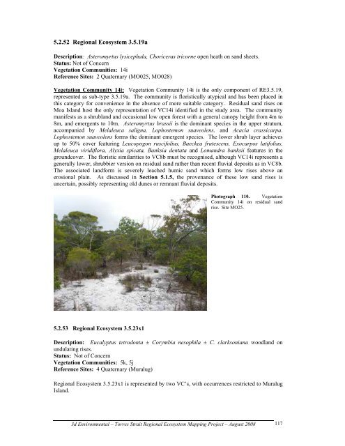
5.2.52 <strong>Regional</strong> Ecosystem 3.5.19a<br />
Description: Asteromyrtus lysicephala, Choriceras tricorne open heath on s<strong>and</strong> sheets.<br />
Status: Not of Concern<br />
<strong>Vegetation</strong> <strong>Communities</strong>: 14i<br />
Reference Sites: 2 Quaternary (MO025, MO028)<br />
<strong>Vegetation</strong> Community 14i: <strong>Vegetation</strong> Community 14i is the only component of RE3.5.19,<br />
represented as sub-type 3.5.19a. The community is floristically atypical <strong>and</strong> has been placed in<br />
this category for convenience in the absence of more suitable category. Residual s<strong>and</strong> rises on<br />
Moa Isl<strong>and</strong> host the only representation of VC14i identified in the study area. The community<br />
manifests as a shrubl<strong>and</strong> <strong>and</strong> occasional low open forest with a general canopy height from 4m to<br />
8m, <strong>and</strong> emergents to 10m. Asteromyrtus brassii is the dominant species in the upper stratum,<br />
accompanied by Melaleuca saligna, Lophostemon suaveolens, <strong>and</strong> Acacia crassicarpa.<br />
Lophostemon suaveolens forms the dominant emergent species. The lower shrub layer achieves<br />
up to 50% cover featuring Leucopogon ruscifolius, Baeckea frutescens, Exocarpos latifolius,<br />
Melaleuca viridiflora, Alyxia spicata, Banksia dentata <strong>and</strong> Lom<strong>and</strong>ra banksii features in the<br />
groundcover. The floristic similarities to VC8b must be recognised, although VC14i represents a<br />
generally lower, shrubbier version on residual s<strong>and</strong> rather than recent fluvial deposits as in VC8b.<br />
The associated l<strong>and</strong>form is severely leached humic s<strong>and</strong> which forms low rises above an<br />
erosional plain. As discussed in Section 5.1.5, the provenance of these low s<strong>and</strong> rises is<br />
uncertain, possibly representing old dunes or remnant fluvial deposits.<br />
5.2.53 <strong>Regional</strong> Ecosystem 3.5.23x1<br />
Photograph 110. <strong>Vegetation</strong><br />
Community 14i on residual s<strong>and</strong><br />
rise. Site MO25.<br />
Description: Eucalyptus tetrodonta ± Corymbia nesophila ± C. clarksoniana woodl<strong>and</strong> on<br />
undulating rises.<br />
Status: Not of Concern<br />
<strong>Vegetation</strong> <strong>Communities</strong>: 5k, 5j<br />
Reference Sites: 4 Quaternary (Muralug)<br />
<strong>Regional</strong> Ecosystem 3.5.23x1 is represented by two VC’s, with occurrences restricted to Muralug<br />
Isl<strong>and</strong>.<br />
3d Environmental – Torres Strait <strong>Regional</strong> Ecosystem Mapping Project – August 2008<br />
117