

Appendix 2 - Vegetation Communities and Regional Ecosystems
Appendix 2 - Vegetation Communities and Regional Ecosystems
Appendix 2 - Vegetation Communities and Regional Ecosystems

You also want an ePaper? Increase the reach of your titles
YUMPU automatically turns print PDFs into web optimized ePapers that Google loves.
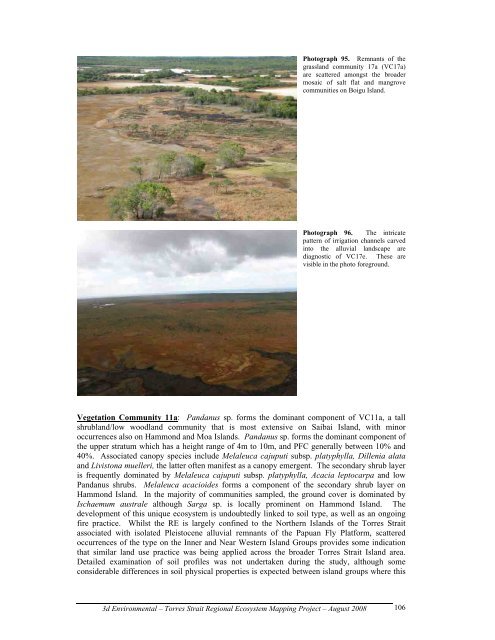
Photograph 95. Remnants of the<br />
grassl<strong>and</strong> community 17a (VC17a)<br />
are scattered amongst the broader<br />
mosaic of salt flat <strong>and</strong> mangrove<br />
communities on Boigu Isl<strong>and</strong>.<br />
Photograph 96. The intricate<br />
pattern of irrigation channels carved<br />
into the alluvial l<strong>and</strong>scape are<br />
diagnostic of VC17e. These are<br />
visible in the photo foreground.<br />
<strong>Vegetation</strong> Community 11a: P<strong>and</strong>anus sp. forms the dominant component of VC11a, a tall<br />
shrubl<strong>and</strong>/low woodl<strong>and</strong> community that is most extensive on Saibai Isl<strong>and</strong>, with minor<br />
occurrences also on Hammond <strong>and</strong> Moa Isl<strong>and</strong>s. P<strong>and</strong>anus sp. forms the dominant component of<br />
the upper stratum which has a height range of 4m to 10m, <strong>and</strong> PFC generally between 10% <strong>and</strong><br />
40%. Associated canopy species include Melaleuca cajuputi subsp. platyphylla, Dillenia alata<br />
<strong>and</strong> Livistona muelleri, the latter often manifest as a canopy emergent. The secondary shrub layer<br />
is frequently dominated by Melaleuca cajuputi subsp. platyphylla, Acacia leptocarpa <strong>and</strong> low<br />
P<strong>and</strong>anus shrubs. Melaleuca acacioides forms a component of the secondary shrub layer on<br />
Hammond Isl<strong>and</strong>. In the majority of communities sampled, the ground cover is dominated by<br />
Ischaemum australe although Sarga sp. is locally prominent on Hammond Isl<strong>and</strong>. The<br />
development of this unique ecosystem is undoubtedly linked to soil type, as well as an ongoing<br />
fire practice. Whilst the RE is largely confined to the Northern Isl<strong>and</strong>s of the Torres Strait<br />
associated with isolated Pleistocene alluvial remnants of the Papuan Fly Platform, scattered<br />
occurrences of the type on the Inner <strong>and</strong> Near Western Isl<strong>and</strong> Groups provides some indication<br />
that similar l<strong>and</strong> use practice was being applied across the broader Torres Strait Isl<strong>and</strong> area.<br />
Detailed examination of soil profiles was not undertaken during the study, although some<br />
considerable differences in soil physical properties is expected between isl<strong>and</strong> groups where this<br />
3d Environmental – Torres Strait <strong>Regional</strong> Ecosystem Mapping Project – August 2008<br />
106