

Appendix 2 - Vegetation Communities and Regional Ecosystems
Appendix 2 - Vegetation Communities and Regional Ecosystems
Appendix 2 - Vegetation Communities and Regional Ecosystems

You also want an ePaper? Increase the reach of your titles
YUMPU automatically turns print PDFs into web optimized ePapers that Google loves.
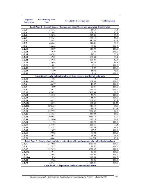
<strong>Regional</strong><br />
Ecosystem<br />
Pre-clearing Area<br />
(ha)<br />
Area (2007 Coverage-ha) % Remaining<br />
L<strong>and</strong> Zone 2 - Coastal Dunes, Cheniers <strong>and</strong> S<strong>and</strong> Sheets <strong>and</strong> associated Dune Swales.<br />
3.2.2 368.12 264.4 71.8<br />
3.2.3 111.962 109.18 97.5<br />
3.2.4 320.32 313.43 97.8<br />
3.2.5 646.21 561.16 86.8<br />
3.2.6 285.81 193.148 67.5<br />
3.2.7 605.45 599.41 99.0<br />
3.2.8 60.44 60.44 100.0<br />
3.2.10 128.89 128.99 100.0<br />
3.2.14 0.46 0.46 100.0<br />
3.2.15 967.02 745.1 77.1<br />
3.2.19 167.83 160.08 95.4<br />
3.2.24 359.16 296.23 82.5<br />
3.2.25 39.84 35.76 89.8<br />
3.2.26 80.1 80.1 100.0<br />
3.2.27 4.27 4.27 100.0<br />
3.2.28 188.80 85.72 45.4<br />
3.2.30 3.14 3.14 100.0<br />
L<strong>and</strong> Zone 3 - Alluvial plains, alluvial fans, terraces <strong>and</strong> fluvial sediments<br />
3.3.1c 8.03 0 0.0<br />
3.3.5c 103.83 103.83 100.0<br />
3.3.6 46.97 46.97 100.0<br />
3.3.7 18.09 10.95 100.0<br />
3.3.9 179.77 179.77 100.0<br />
3.3.10 476.21 467.00 98.0<br />
3.3.12 33.75 33.75 100.0<br />
3.3.13 55.47 55.47 100.0<br />
3.3.14 208.75 204.32 97.8<br />
3.3.17b 185.33 182.05 98.23<br />
3.3.20c 1143..37 1120.68 98.0<br />
3.3.22 553.72 537.6 97.08<br />
3.3.27 2277.73 2201.02 96.6<br />
3.3.28 253.21 227.39 89.8<br />
3.3.42 2999.52 2931.18 97.7<br />
3.3.48 1124.00 1112.13 98.9<br />
3.3.51 111.72 111.72 100.0<br />
3.3.57 273.07 211.61 77.5<br />
3.3.62 1331.87 1290.36 96.9<br />
3.3.63 105.7 105.7 100.0<br />
3.3.68 90.02 90.02 100.0<br />
3.3.69 139.82 65.60 46.9<br />
3.3.70 148.41 144.254 97.1<br />
L<strong>and</strong> Zone 5 – S<strong>and</strong>y plains <strong>and</strong> rises/ Lateritic profiles <strong>and</strong> remnant alluvial/colluvial surfaces.<br />
3.5.5 2110.88 2110.88 100.0<br />
3.5.8 73.37 73.37 100.0<br />
3.5.15 3273.32 3273.32 100.0<br />
3.5.17a 10.44 10.44 100.0<br />
3.5.19 229.93 229.93 100.0<br />
3.5.23x1 115.54 115.54 100.0<br />
3.5.29 59.26 59.26 100.0<br />
3.5.32 228.21 228.21 100.0<br />
L<strong>and</strong> Zone 7 – Exposed or shallowly covered duricrust<br />
3d Environmental – Torres Strait <strong>Regional</strong> Ecosystem Mapping Project – August 2008<br />
174