

Appendix 2 - Vegetation Communities and Regional Ecosystems
Appendix 2 - Vegetation Communities and Regional Ecosystems
Appendix 2 - Vegetation Communities and Regional Ecosystems

You also want an ePaper? Increase the reach of your titles
YUMPU automatically turns print PDFs into web optimized ePapers that Google loves.
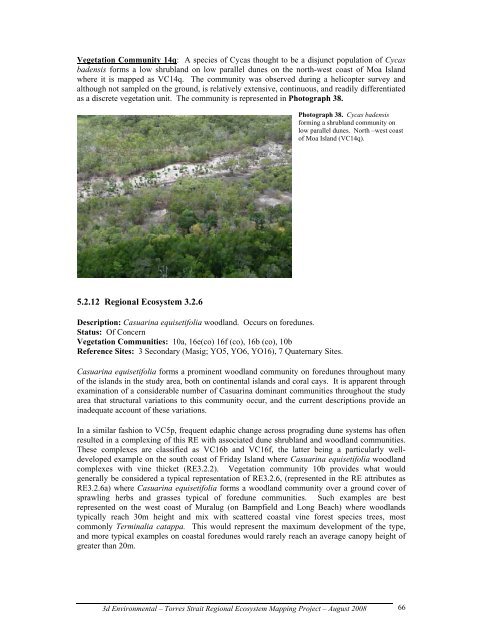
<strong>Vegetation</strong> Community 14q: A species of Cycas thought to be a disjunct population of Cycas<br />
badensis forms a low shrubl<strong>and</strong> on low parallel dunes on the north-west coast of Moa Isl<strong>and</strong><br />
where it is mapped as VC14q. The community was observed during a helicopter survey <strong>and</strong><br />
although not sampled on the ground, is relatively extensive, continuous, <strong>and</strong> readily differentiated<br />
as a discrete vegetation unit. The community is represented in Photograph 38.<br />
5.2.12 <strong>Regional</strong> Ecosystem 3.2.6<br />
Description: Casuarina equisetifolia woodl<strong>and</strong>. Occurs on foredunes.<br />
Status: Of Concern<br />
<strong>Vegetation</strong> <strong>Communities</strong>: 10a, 16e(co) 16f (co), 16b (co), 10b<br />
Reference Sites: 3 Secondary (Masig; YO5, YO6, YO16), 7 Quaternary Sites.<br />
Photograph 38. Cycas badensis<br />
forming a shrubl<strong>and</strong> community on<br />
low parallel dunes. North –west coast<br />
of Moa Isl<strong>and</strong> (VC14q).<br />
Casuarina equisetifolia forms a prominent woodl<strong>and</strong> community on foredunes throughout many<br />
of the isl<strong>and</strong>s in the study area, both on continental isl<strong>and</strong>s <strong>and</strong> coral cays. It is apparent through<br />
examination of a considerable number of Casuarina dominant communities throughout the study<br />
area that structural variations to this community occur, <strong>and</strong> the current descriptions provide an<br />
inadequate account of these variations.<br />
In a similar fashion to VC5p, frequent edaphic change across prograding dune systems has often<br />
resulted in a complexing of this RE with associated dune shrubl<strong>and</strong> <strong>and</strong> woodl<strong>and</strong> communities.<br />
These complexes are classified as VC16b <strong>and</strong> VC16f, the latter being a particularly welldeveloped<br />
example on the south coast of Friday Isl<strong>and</strong> where Casuarina equisetifolia woodl<strong>and</strong><br />
complexes with vine thicket (RE3.2.2). <strong>Vegetation</strong> community 10b provides what would<br />
generally be considered a typical representation of RE3.2.6, (represented in the RE attributes as<br />
RE3.2.6a) where Casuarina equisetifolia forms a woodl<strong>and</strong> community over a ground cover of<br />
sprawling herbs <strong>and</strong> grasses typical of foredune communities. Such examples are best<br />
represented on the west coast of Muralug (on Bampfield <strong>and</strong> Long Beach) where woodl<strong>and</strong>s<br />
typically reach 30m height <strong>and</strong> mix with scattered coastal vine forest species trees, most<br />
commonly Terminalia catappa. This would represent the maximum development of the type,<br />
<strong>and</strong> more typical examples on coastal foredunes would rarely reach an average canopy height of<br />
greater than 20m.<br />
3d Environmental – Torres Strait <strong>Regional</strong> Ecosystem Mapping Project – August 2008<br />
66