

Appendix 2 - Vegetation Communities and Regional Ecosystems
Appendix 2 - Vegetation Communities and Regional Ecosystems
Appendix 2 - Vegetation Communities and Regional Ecosystems

Create successful ePaper yourself
Turn your PDF publications into a flip-book with our unique Google optimized e-Paper software.
community where it is mapped as complex 16a, <strong>and</strong> with microphyll vine thicket where it is<br />
mapped as VC16j. The two dominant components, VC16i <strong>and</strong> VC14y, are discussed briefly<br />
below.<br />
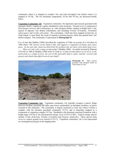
<strong>Vegetation</strong> Community 16i: <strong>Vegetation</strong> community 16i represents open tussock grassl<strong>and</strong> with<br />
emergent shrubs, verging on a sparse shrubl<strong>and</strong> in some locations. Ground cover is composed of<br />
Heteropogon triticeus <strong>and</strong> Cymbopogon sp. with emergent shrubs, ranging in height from 1-2m,<br />
typical of adjacent vine thicket communities <strong>and</strong> including Premna serratifolia, Terminalia<br />
subacroptera <strong>and</strong> Cordia subcordata. The community, which has been mapped exclusively on<br />
Tudu Isl<strong>and</strong>, is most likely the result of repetitive burning practice which has pushed back vine<br />
thicket margins. The community is represented in Photograph 54.<br />
It is of note that Haddon (1888) described the vegetation of Tudu on account of a visit there in<br />
1888 where “The interior of the isl<strong>and</strong> is flat, <strong>and</strong> supports a vegetation of bushes <strong>and</strong> coarse<br />
grass. In one spot only, about one-third from the northern end, are there a few fairly large trees,<br />
……. There are only a few young coconut palms” (Haddon 1888). An earlier account by Dumont<br />
d’Urville in 1840 in Haddon (1888) refers to Tudu as “a bank of s<strong>and</strong> almost at sea level, on the<br />
north point is a clump of trees, the rest of this miserable l<strong>and</strong> is saline, marshy, covered with<br />
grasses <strong>and</strong> shrubs that afford scarcely any shade”.<br />
Photograph 54. Open tussock<br />
grassl<strong>and</strong> with emergent shrubs on<br />
Tudu Isl<strong>and</strong> (VC16i).<br />
<strong>Vegetation</strong> Community 14y: <strong>Vegetation</strong> community 14y typically occupies a narrow fringe<br />
between foredune grassl<strong>and</strong> <strong>and</strong> taller open forest communities in backdune localities, in places<br />
ecotonal to this transition. The community is largely restricted to coral cays where it forms a<br />
complex with the foredune grassl<strong>and</strong> community VC17j, <strong>and</strong> is frequently mapped as a<br />
component of vegetation complex VC16a. Shrubl<strong>and</strong> is the dominant structural formation with a<br />
height range of 0.5m to 2m <strong>and</strong> projected canopy cover of 25% to 60%. Typical canopy species<br />
include Cordia dichotoma, Premna serratifolia <strong>and</strong> Drypetes deplanchei. These species form<br />
cover to a sparse ground cover typical of VC17j. <strong>Vegetation</strong> community 14y is not represented<br />
as a homogenous polygon in the mapping data.<br />
3d Environmental – Torres Strait <strong>Regional</strong> Ecosystem Mapping Project – August 2008<br />
77