

Appendix 2 - Vegetation Communities and Regional Ecosystems
Appendix 2 - Vegetation Communities and Regional Ecosystems
Appendix 2 - Vegetation Communities and Regional Ecosystems

Create successful ePaper yourself
Turn your PDF publications into a flip-book with our unique Google optimized e-Paper software.
The extensive mosaic of grassl<strong>and</strong> <strong>and</strong> low closed forest on steep granite hillslopes on Moa Isl<strong>and</strong><br />
provides the only mapped representation of this RE in the exercise. More intensive field survey<br />
is likely to result in additional representation. Several areas mapped as RE13.12.29 may be more<br />
appropriately represented under this RE.<br />
<strong>Vegetation</strong> Community 17f: The Moa Isl<strong>and</strong> example forms an extensive grassl<strong>and</strong> complex<br />
dominated by Imperata cylindrica. Closed forest communities of Welchiodendron are restricted<br />
to fire protected gullies <strong>and</strong> boulder piles where they are represented as RE3.12.4, although due<br />
to scale limitations, these could not be adequately differentiated from the broader grassl<strong>and</strong><br />
system. The grassl<strong>and</strong>/Welchiodendron open forest complex is represented as VC17h. The<br />
current representation of this RE is clearly influenced by repetitive firing of the slopes which has<br />
caused retreat of the once dominant closed forest communities in favour of Imperata dominant<br />
grassl<strong>and</strong>. This community is in a state of relative stability with little change in areal extent<br />
indicated between 1974 aerial photography <strong>and</strong> recent satellite imagery.<br />
5.2.71 <strong>Regional</strong> Ecosystem 3.12.31x1a (New RE)<br />
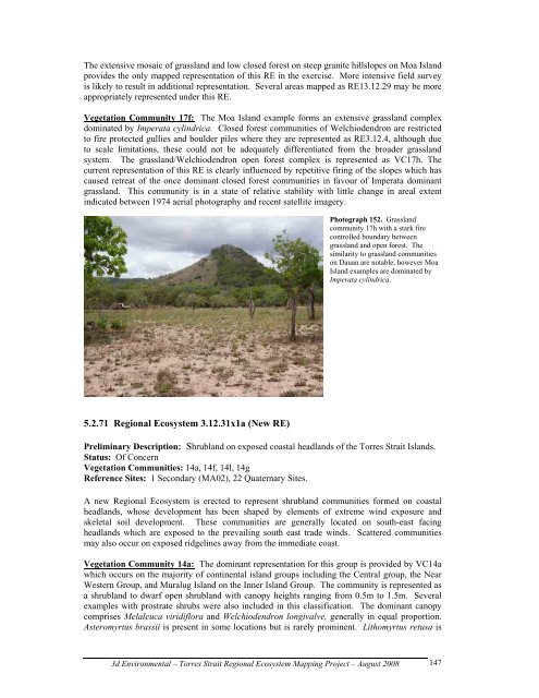
Photograph 152. Grassl<strong>and</strong><br />
community 17h with a stark fire<br />
controlled boundary between<br />
grassl<strong>and</strong> <strong>and</strong> open forest. The<br />
similarity to grassl<strong>and</strong> communities<br />
on Dauan are notable, however Moa<br />
Isl<strong>and</strong> examples are dominated by<br />
Imperata cylindrica.<br />
Preliminary Description: Shrubl<strong>and</strong> on exposed coastal headl<strong>and</strong>s of the Torres Strait Isl<strong>and</strong>s.<br />
Status: Of Concern<br />
<strong>Vegetation</strong> <strong>Communities</strong>: 14a, 14f, 14l, 14g<br />
Reference Sites: 1 Secondary (MA02), 22 Quaternary Sites.<br />
A new <strong>Regional</strong> Ecosystem is erected to represent shrubl<strong>and</strong> communities formed on coastal<br />
headl<strong>and</strong>s, whose development has been shaped by elements of extreme wind exposure <strong>and</strong><br />
skeletal soil development. These communities are generally located on south-east facing<br />
headl<strong>and</strong>s which are exposed to the prevailing south east trade winds. Scattered communities<br />
may also occur on exposed ridgelines away from the immediate coast.<br />
<strong>Vegetation</strong> Community 14a: The dominant representation for this group is provided by VC14a<br />
which occurs on the majority of continental isl<strong>and</strong> groups including the Central group, the Near<br />
Western Group, <strong>and</strong> Muralug Isl<strong>and</strong> on the Inner Isl<strong>and</strong> Group. The community is represented as<br />
a shrubl<strong>and</strong> to dwarf open shrubl<strong>and</strong> with canopy heights ranging from 0.5m to 1.5m. Several<br />
examples with prostrate shrubs were also included in this classification. The dominant canopy<br />
comprises Melaleuca viridiflora <strong>and</strong> Welchiodendron longivalve, generally in equal proportion.<br />
Asteromyrtus brassii is present in some locations but is rarely prominent. Lithomyrtus retusa is<br />
3d Environmental – Torres Strait <strong>Regional</strong> Ecosystem Mapping Project – August 2008<br />
147