

Appendix 2 - Vegetation Communities and Regional Ecosystems
Appendix 2 - Vegetation Communities and Regional Ecosystems
Appendix 2 - Vegetation Communities and Regional Ecosystems

Create successful ePaper yourself
Turn your PDF publications into a flip-book with our unique Google optimized e-Paper software.
5.5 Other Classifications<br />
Areas Represented as R: Areas labelled R represent bare rock pavement formed on volcanic,<br />
granitoid or basaltic lithologies. Such areas lack soil development in any form <strong>and</strong> are generally<br />
found in exposed <strong>and</strong> precipitous locations, often at the base of coastal escarpments immediately<br />
above the intertidal zone. These areas are typically devoid of vegetation due to extreme exposure<br />
to both wind <strong>and</strong> salt spray, although stunted shrubs, herbs <strong>and</strong> grasses may occupy rock fractures<br />
where some shelter is provided. Due to extremely steep terrain, these communities are likely to<br />
be under-represented in the mapping with many areas obscured by steep slopes.<br />
6.0 Spatial Extent of <strong>Regional</strong> <strong>Ecosystems</strong><br />
The spatial analysis of regional ecosystems presented in Table 11 below, which compares preclearing<br />
extent with contemporary representation, enables the area of current vegetation cover to<br />
be compared to the pre-clearing extent. Results indicate that 98.9% of remnant vegetation cover<br />
remains. The most extensive loss of remnant vegetation cover is attributable to the following<br />
RE’s.<br />
• RE 3.7.1x1, a vine thicket type which is now restricted to narrow fragments adjacent to<br />
roadsides on ironstone exposures on the northern shores of Saibai Isl<strong>and</strong> (0.4% remains<br />
in remnant condition;<br />
• RE 3.2.28, Evergreen notophyll vine forest on beach ridges on coral atolls, shingle cays<br />
<strong>and</strong> s<strong>and</strong> cays (45.4% remaining). Heavily impacted on Aureed, Warraber, <strong>and</strong> Masig;<br />
• RE 3.3.69, Melaleuca dealbata <strong>and</strong> Corymbia clarksoniana open forest on alluvial plains<br />
restricted to Moa (47% remaining);<br />
• RE 3.8.5, Semi deciduous <strong>and</strong> deciduous vine thicket restricted to Erub <strong>and</strong> Mer (58.8%<br />
remaining). Heavily fragmented through past native gardening with significant areas<br />
have been replaced by bamboo;<br />
• RE 3.12.13, Corymbia nesophila ± C. hyl<strong>and</strong>ii subsp. peninsularis woodl<strong>and</strong> on acid<br />
volcanic hills, restricted to Thursday, Zuna <strong>and</strong> Muralug (66.7% remaining);<br />
• RE 3.2.6, Casuarina equisetifolia woodl<strong>and</strong> of coastal foredunes (67.5% remaining).<br />
Heavily impacted community on foreshores in a number of isl<strong>and</strong> groups;<br />
• RE 3.2.15, Melaleuca viridiflora, Neofabricia myrtifolia woodl<strong>and</strong> on beach ridges<br />
occurring on Badu, Horn <strong>and</strong> Muralug (77.1% remaining). Nearly all of the clearing of<br />
this RE is associated with increased urbanization on Badu including clearing for airstrips<br />
(old <strong>and</strong> new); <strong>and</strong><br />
• RE 3.3.57, Tussock grassl<strong>and</strong> on coastal plains of Moa, Gebar <strong>and</strong> Muralug (77.5%<br />
remaining). A fire disclimaz community that has been impacted by clearing on Moa<br />
Isl<strong>and</strong> (St Pauls).<br />
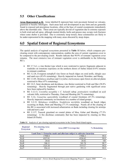
Table 11. Analysis of pre-clearing regional ecosystems in the Torres Strait Isl<strong>and</strong> region.<br />
<strong>Regional</strong><br />
Ecosystem<br />
Pre-clearing Area<br />
(ha)<br />
Area (2007 Coverage-ha) % Remaining<br />
L<strong>and</strong> Zone 1- Estuarine muds <strong>and</strong> alluvium subject to saltwater incursion<br />
3.1.1 17908.8 17886.3 99.8<br />
3.1.2 4327.01 4326.62 99.8<br />
3.1.4 20.02 20.02 100<br />
3.1.5 346.11 341.74 98.7<br />
3.1.6 3325.38 3319.27 99.8<br />
3.1.7 954.12 953.13 99.9<br />
3d Environmental – Torres Strait <strong>Regional</strong> Ecosystem Mapping Project – August 2008<br />
173