

Appendix 2 - Vegetation Communities and Regional Ecosystems
Appendix 2 - Vegetation Communities and Regional Ecosystems
Appendix 2 - Vegetation Communities and Regional Ecosystems

You also want an ePaper? Increase the reach of your titles
YUMPU automatically turns print PDFs into web optimized ePapers that Google loves.
This community presents some difficulty for classification in a l<strong>and</strong>form sense. The low s<strong>and</strong>y<br />
rises that it occupies are scattered across a broader erosional surface <strong>and</strong> their provenance is not<br />
clear. It is considered that these features may represent relict beach ridges, although their<br />
morphology has been degraded to a degree that confirmation of this is not possible. The low rises<br />
also support forest communities that are atypical of degraded dune systems examined in other<br />
locations, more typically occupied by stunted shrubl<strong>and</strong>s. That the vegetation community<br />
comprises species typically associated with swampl<strong>and</strong>s is also puzzling when it is considered<br />
that the ridges are elevated above the surrounding erosional plain <strong>and</strong> provide reasonable<br />
drainage. Given that the surrounding l<strong>and</strong>form is erosional presents the possibility that these<br />
features are the result of a topographic reversal <strong>and</strong> the forest communities represent former<br />
swampl<strong>and</strong>s on a previous depositional surface. The species composition of the forest gives<br />
some support to this possibility. Without the ability to positively identify these features, they<br />
have been classified with the broader erosional plain as LZ5 features. A new RE is proposed to<br />
accommodate this community under the preliminary classification of RE3.5.4x6.<br />
5.2.56 <strong>Regional</strong> Ecosystem 3.7.1x1b<br />
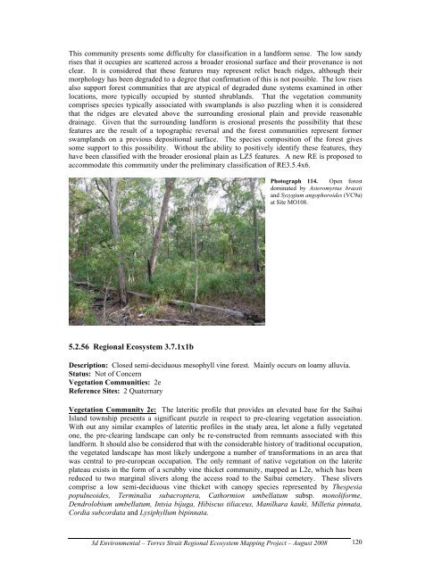
Photograph 114. Open forest<br />
dominated by Asteromyrtus brassii<br />
<strong>and</strong> Syzygium angophoroides (VC9a)<br />
at Site MO108.<br />
Description: Closed semi-deciduous mesophyll vine forest. Mainly occurs on loamy alluvia.<br />
Status: Not of Concern<br />
<strong>Vegetation</strong> <strong>Communities</strong>: 2e<br />
Reference Sites: 2 Quaternary<br />
<strong>Vegetation</strong> Community 2e: The lateritic profile that provides an elevated base for the Saibai<br />
Isl<strong>and</strong> township presents a significant puzzle in respect to pre-clearing vegetation association.<br />
With out any similar examples of lateritic profiles in the study area, let alone a fully vegetated<br />
one, the pre-clearing l<strong>and</strong>scape can only be re-constructed from remnants associated with this<br />
l<strong>and</strong>form. It should also be considered that with the considerable history of traditional occupation,<br />
the vegetated l<strong>and</strong>scape has most likely undergone a number of transformations in an area that<br />
was central to pre-european occupation. The only remnant of native vegetation on the laterite<br />
plateau exists in the form of a scrubby vine thicket community, mapped as L2e, which has been<br />
reduced to two marginal slivers along the access road to the Saibai cemetery. These slivers<br />
comprise a low semi-deciduous vine thicket with canopy species represented by Thespesia<br />
populneoides, Terminalia subacroptera, Cathormion umbellatum subsp. monoliforme,<br />
Dendrolobium umbellatum, Intsia bijuga, Hibiscus tiliaceus, Manilkara kauki, Milletia pinnata,<br />
Cordia subcordata <strong>and</strong> Lysiphyllum bipinnata.<br />
3d Environmental – Torres Strait <strong>Regional</strong> Ecosystem Mapping Project – August 2008<br />
120